Posted on — Leave a comment

The Race to Save North Carolina’s Peatlands

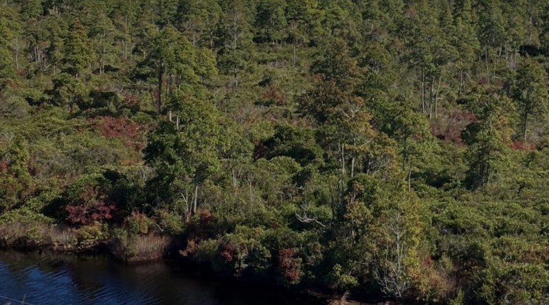
Dense forest along a calm waterway, with green and autumn-colored trees. (Aerial view)

When people think of peat bogs, their minds might head to Europe, to the bogs of the British Isles, famous for their “bog bodies“. Or perhaps they might think of the boreal peat bogs of the frozen north; but many probably do not think of the peatlands present along the Eastern Seaboard of the United States. In North Carolina, the race is on to preserve and protect the state’s remaining peat bogs before they dry up or worse, catch fire and burn out of control. Accounting for only about 3% of the Earth’s surface, peatlands are responsible for storing one-third of the carbon dioxide on our planet. When degraded, destroyed, or burned, huge amounts of greenhouse gases are released. The protection and restoration project in the Inner Banks of North Carolina is being undertaken with the ultimate goal of selling carbon credits to corporations that want to offset their own greenhouse gas emissions.

Adjacent to the Pocosin Lakes National Wildlife Refuge, where peatland restoration efforts have been underway for several years, the latest peat bog project is led by Pantheon Regeneration and guided by scientists with Duke University. Domed peatland is comprised of organic matter from coastal pine forests and evergreen shrubbery that has decayed over millennia and is known as Pocosin peat. Found only along the Eastern Seaboard, Pocosin peat ecosystems are under threat, primarily from habitat destruction at the hands of humans and sometimes even Mother Nature herself. In 2008, a lightning strike in the eastern portion of the Pocosin Lakes National Wildlife Refuge started a wildfire that burned for three months above ground. Belowground, the peat continued to burn for four more months, resulting in the ground lowering by a foot and a half in some places. In areas of the refuge that had already undergone some hydrology restoration, the fires burned with less intensity, as the peat was moister in those spots.

Pantheon Regeneration selected the current project site because they feel that the urgency now is to restore degraded peatlands before they are completely destroyed. The plan is to block off drainage ditches and canals that had originally been constructed to drain the peat and make it into suitable farmland. In blocking off those ditches, the water level can be restored, bringing water back to the peatland, staving off wildfire disaster, and creating habitat for wildlife that will, hopefully one day, become a biodiversity hotspot like the neighboring Pocosin Lakes National Wildlife Refuge.  

By selling carbon credits from this restored peatland, Pantheon Regeneration hopes to use those funds to purchase more degraded peatland for restoration as well as peatland that is still relatively well-preserved. While the concept of carbon credits, where corporations invest in projects such as peatland restoration and preservation to offset their own greenhouse gas emissions, is controversial, Pantheon is taking a more scientific approach, using decades of data collected by Duke University researchers Dr. Curtis Richardson and Dr. Neal Flanagan and the Duke University Wetland and Coasts Center to ensure that accurate levels of how much carbon is being captured and stored are used to determine the credits. Perhaps this project will inspire others to learn more about the unique peat bog habitat that calls North Carolina home, and to strive to restore and protect it. 

#NorthCarolina #Peatlands #WetlandRestoration #Conservation #Wetlands #PocosinNationalWildlifeRefuge #WetlandWednesday #TheSwampSchool

Posted on — Leave a comment

The New WOTUS Proposal Promises Less Paperwork. It Could Create a Corps Backlog.

The proposal promises less paperwork, but it could turn one wetland delineation into two boundary investigations—and the agencies have not published a method for drawing the second boundary.

By Marc Seelinger, SPWS

EPA and the Department of the Army published a new WOTUS proposal today that could remove most intermittent streams—and potentially large portions of many wetlands—from federal Clean Water Act jurisdiction.

It is being presented as deregulation. The agencies predict fewer federal permits, lower costs, and greater certainty. The Army has placed the effort under its “Building Infrastructure, Not Paperwork” initiative.

But there is a serious problem: the agencies have not provided a credible method for applying either of the new jurisdictional tests.

The proposal may reduce federal jurisdiction. It does not reduce the work needed to prove where jurisdiction ends. In practice, it could create more investigations, more disputes, and a new nationwide backlog of Corps jurisdictional-determination reviews.

That helps no one—not even developers.

The Supplemental Notice of Proposed Rulemaking was published September 9, 2026, at 91 FR 57284. Comments are due October 9 under Docket No. EPA-HQ-OW-2025-0322. Read the published proposal.

Two new alternatives

The proposal adds two alternatives to the WOTUS rule proposed in November 2025. Neither is current law.

The first would generally limit “relatively permanent waters” to perennial waters. A stream would need standing or continuously flowing water every day of an ordinary year. One ordinary interruption lasting up to 30 consecutive days could be allowed.

The word one creates an immediate problem. A stream that is dry once for 30 days could qualify. A stream that is dry twice for one day each could fail—even though the second stream contains water on 28 more days during the year.

That is a legal bright line, not a scientifically credible measure of stream permanence. The agencies acknowledge that there is no precise, scientifically grounded, nationally consistent basis for the 30-day limit.

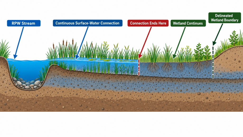
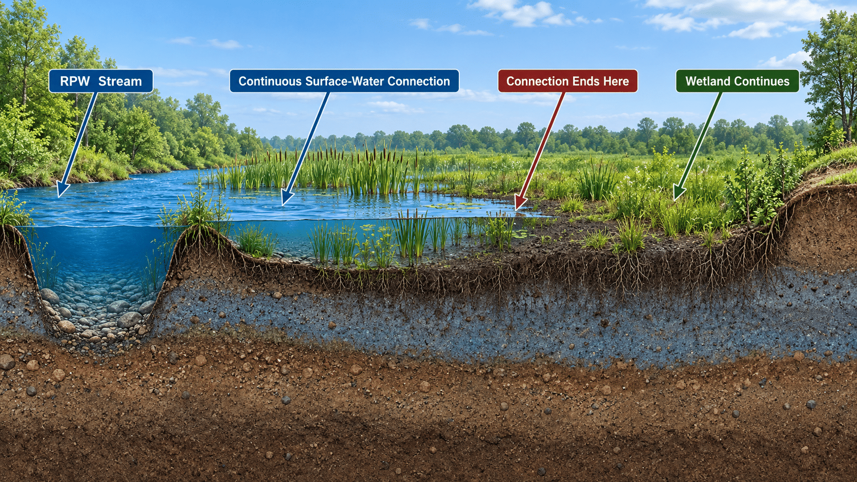
The second alternative concerns wetlands. It would require perennial surface water within a wetland to be continuously connected to surface water in a jurisdictional water. The connection must make it difficult to tell where the jurisdictional water ends and the wetland begins.

Only the connected portion of the wetland might be federally jurisdictional. This could create two separate boundaries on the same property: the scientifically delineated wetland boundary and a new federal boundary somewhere inside it.

The agencies anticipate that most intermittent streams would fail the first test. They also anticipate that a majority of wetlands currently regulated as adjacent wetlands would fail the second because most wetlands do not contain perennial surface water.

There is no published procedure for making these decisions

The Swamp School reviewed the proposal, existing Corps and ERDC procedures, and relevant scientific literature. We found useful methods for studying streamflow duration and wetland connectivity. We did not find a validated procedure capable of answering the exact legal questions the agencies propose.

A one-time site visit cannot establish whether water was present every day of an ordinary year. Finding a dry stream does not reveal when it dried, whether this was its first or second interruption, or whether the cause was ordinary or anomalous.

Streamflow Duration Assessment Methods can estimate whether a stream is typically ephemeral, intermittent, or perennial. They do not reconstruct a day-by-day record or distinguish one interruption from two. EPA scientists have explained that streamflow duration exists along a continuum and that classifications require regional calibration and treatment of uncertainty. Fritz et al. (2020)

Maps, models, and satellite imagery cannot fill the gap. Tree canopy, shadows, narrow channels, shallow water, cloud cover, mapping errors, and time between images prevent them from proving daily surface-water conditions at property scale.

For wetlands, the problem is harder. Existing delineation methods identify the boundary between wetland and non-wetland. They were not designed to locate a second boundary inside one continuous wetland based on the daily persistence of surface water.

Published connectivity studies have required water-level instruments, repeated site visits, precipitation records, channel inspections, and elevation data. That research is valuable, but it is not a national jurisdictional-boundary protocol. McDonough et al. (2015)

The proposal nevertheless suggests that a landowner could identify the connected portion of a wetland by observation or “the naked eye.” That claim is difficult to reconcile with a test requiring proof of perennial water, ordinary conditions, drought exceptions, and no more than one qualifying interruption.

Why developers should be concerned

The agencies assume narrower jurisdiction will mean fewer Section 404 permits and lower costs. That may be true after a property owner obtains a defensible non-jurisdictional decision. The unanswered question is what it will cost—and how long it will take—to get that decision.

A developer cannot finance and design a project based on a national estimate that “most” intermittent streams or wetlands will be excluded. The developer needs a reliable answer for the specific property. Lenders, purchasers, engineers, local governments, and investors may also demand Corps confirmation.

Under the new alternatives, consultants may need to document streamflow over time, distinguish ordinary conditions from drought, investigate separate interruptions, map perennial surface water inside wetlands, and defend an internal jurisdictional boundary.

That work occurs before anyone knows whether a permit has been avoided.

Delays at that stage can affect purchase contracts, financing, engineering plans, local approvals, construction schedules, and mitigation decisions. A theoretical reduction in jurisdiction has little value if the project waits months for an answer that no published method can reliably produce.

Why the Corps backlog could grow

Without a national procedure, each Corps district—and potentially each project manager—will have to decide what evidence is sufficient.

How many site visits are enough? How long must monitoring continue? What water depth counts? Where should sensors be placed? Which drought category controls? What happens when field observations conflict with maps or imagery? How is the internal wetland boundary surveyed?

Different applicants will submit different evidence. Corps reviewers will request additional information, resolve conflicting indicators, and prepare decisions capable of surviving administrative appeals and litigation.

The likely result is more case-by-case analysis and more requests for AJDs. The Corps may eventually process fewer permit applications, but it could first inherit a larger and substantially more complicated jurisdictional-review workload.

This is paperwork moved to the front of the project, where delay is often most expensive.

A rule that helps no one

Developers do not benefit from an uncertain and potentially slower approval process. The Corps does not benefit from being handed new tests without validated procedures or additional resources. Consultants do not benefit from inconsistent district expectations. States and Tribes may inherit responsibility for excluded waters without uniform programs or additional capacity. Environmental interests could lose federal protections without gaining a clear or scientifically defensible boundary.

The agencies should withdraw both alternatives in their current form.

Before adopting either one, EPA and the Army should disclose any technical review conducted by Corps districts or ERDC, complete a geographically representative multi-district pilot study, quantify the expected effect on AJD workloads and processing times, and demonstrate acceptable accuracy and inter-observer reproducibility.

Any resulting methodology should be published for public comment before the jurisdictional standard is finalized—not developed afterward through inconsistent case-by-case decisions.

This is not an argument for broader federal jurisdiction for its own sake. It is an argument for a rule that can actually be implemented.

If the administration wants less regulatory burden, it must evaluate the entire process. A rule that excludes more waters but requires longer, costlier, and less predictable investigations to identify them is not meaningful deregulation.

It is a regulatory backlog waiting to happen.

Comments must be received by October 9, 2026. Identify Docket No. EPA-HQ-OW-2025-0322 and submit comments through Regulations.gov.

Posted on — Leave a comment

Two New WOTUS Alternatives

Why We Are Objecting

EPA and the Army say the new alternatives could provide a clearer jurisdictional line. In the field, they may create more uncertainty, more documentation, and longer Corps reviews.

EPA and the Department of the Army have added two new alternatives to the ongoing rulemaking over the definition of “waters of the United States,” or WOTUS. If adopted, the first could remove most intermittent streams from federal jurisdiction. The second could divide a single scientifically delineated wetland into jurisdictional and non-jurisdictional portions.

That is a major change in how federal jurisdiction could be evaluated. It is also important to say what this announcement is not: these alternatives are proposals, not current law. They should not be used today as the standard for a jurisdictional determination.

The agencies describe the alternatives as possible bright lines that would implement the Supreme Court’s 2023 decision in Sackett v. EPA. The stated goals include predictability, reduced permitting burdens, and a more durable rule. Those are worthwhile goals. Our concern is that neither alternative is supported by a published method capable of producing consistent, defensible decisions in the field.

The problem is not simply that the proposed standards are narrow. The deeper problem is that they ask landowners, consultants, and Corps project managers to prove highly specific hydrologic facts without supplying the measurement rules needed to do so.

Alternative 1: A perennial-only test for relatively permanent waters

The first alternative concerns “relatively permanent waters,” often shortened to RPWs.

Under the agencies’ November 2025 proposal, a water could qualify as relatively permanent if it contained standing or continuously flowing water year-round or at least during the wet season. The new alternative would remove the wet-season option. A water would generally have to be perennial—containing standing or continuously flowing water every day during ordinary conditions.

The proposal provides two possible exceptions. An anomalous event, such as an unusually severe drought or dry spell, would not necessarily cause the water to lose perennial status. The alternative would also allow one regularly occurring interruption lasting no more than 30 consecutive days during the year.

The word “one” matters. A stream that is dry for one continuous 30-day period could still qualify. A stream that is dry for two separate one-day periods could fail, even though it contains water for more days of the year. The agencies also acknowledge that most intermittent streams would not meet the proposed test.

Why Alternative 1 is not scientifically credible

Streamflow duration is real, measurable, and important. But the published science generally treats perennial, intermittent, and ephemeral flow as regional and multi-year hydrologic patterns. Those patterns vary with climate, geology, watershed position, groundwater inputs, water withdrawals, and weather from one year to the next.

The literature does not establish one national, scientifically meaningful breakpoint at one interruption of 30 days. In fact, the supplemental notice acknowledges that there are no precise, scientifically grounded, nationally consistent time limits supporting that number. Calling 30 days approximately one month may make it easy to write into a regulation, but it does not explain why one 30-day dry period is hydrologically acceptable while two much shorter interruptions are not.

The alternative also creates a proof problem. A field visit shows conditions on the day of the visit. It cannot establish that water was present every other day of the year. Seeing a dry channel does not reveal when the dry period began, how long it lasted, whether another interruption occurred elsewhere in the reach, or whether the condition was ordinary or anomalous.

The tools identified by the agencies do not solve that problem:

  • Stream gages provide daily records, but only for a tiny fraction of potentially regulated waters.
  • The Corps’ Antecedent Precipitation Tool and the U.S. Drought Monitor provide climatic context; they do not reconstruct daily flow at a particular stream reach.
  • Streamflow duration assessment methods can help classify a stream from multiple indicators, but they were not designed to count dry days or distinguish one interruption from two.
  • Aerial imagery, national hydrography data, and remote-sensing products are useful screening tools, but their resolution, revisit frequency, canopy limitations, and missing observations prevent them from proving uninterrupted daily flow at parcel scale.
  • Sensors can collect better site-specific records, but the proposal does not say how many are needed, where they must be installed, what counts as detectable water, or how missing data should be handled.

Several essential terms are also unresolved. What is the relevant stream reach? Does water in an isolated pool count as standing water for the whole reach? Which 12-month period controls? When does a normal dry spell become anomalous? How should flow affected by a release, withdrawal, beaver dam, or storm pulse be treated?

Until those questions have objective answers, Alternative 1 is not a bright line. It is a collection of case-by-case judgments hidden behind a precise-looking number.

Alternative 2: Drawing a federal line inside a wetland

The second alternative would apply an equally strict version of the “continuous surface connection” test to wetlands.

Under this approach, a wetland may need perennial surface water that is continuously connected to a jurisdictional water. The connection would need to make it difficult to determine where the jurisdictional water ends and the wetland begins. The same anomalous-event and single 30-day interruption concepts would apply.

The most consequential part is the proposed treatment of the wetland itself. The agencies suggest that only the portion of a wetland containing the required perennial surface-water connection would be jurisdictional. Federal jurisdiction could end where the perennial surface water “runs out,” even though the scientifically delineated wetland continues farther landward.

That would create two different boundaries on the same site:

  1. The wetland boundary established under the Corps Wetlands Delineation Manual and the applicable regional supplement.
  2. A new internal federal jurisdictional boundary based on the extent and duration of surface water.

The land beyond the second line would still be wetland. It could remain regulated under state, Tribal, or local law. But under the proposed federal alternative, it might no longer be WOTUS.

Why Alternative 2 cannot be implemented reliably

No published EPA or Corps manual provides a validated procedure for drawing this internal line. The Corps’ established wetland-delineation methods distinguish wetland from non-wetland using vegetation, soils, and hydrology. They do not divide one continuous wetland into federal and nonfederal portions based on the day-by-day persistence of surface water.

Academic studies can measure when water moves between wetlands and streams. Researchers have used sensors, repeated site visits, detailed elevation surveys, aerial imagery, radar, and satellite data. Those studies are valuable, but they generally produce observations at instrument locations, estimates of inundation extent, or probabilities of connection. They do not produce a stable, survey-ready federal boundary that has been validated across different wetland types and regions.

Wetlands are especially difficult places to draw such a line. Surface water responds to small changes in elevation and may occupy channels, pools, swales, hollows, and depressions. It can disappear at one point while remaining connected by another pathway. The apparent edge can move substantially between seasons and years. Forest canopy may hide shallow water from optical imagery, while many satellite products are too coarse to resolve project-scale conditions.

A one-time “naked eye” observation therefore cannot establish that water was present every day under ordinary conditions. Nor can it determine where that condition ended throughout an irregular wetland. More monitoring might improve the evidence, but the proposal supplies no national requirements for monitoring duration, sensor spacing, water-depth thresholds, survey accuracy, climatic normalization, uncertainty, or conflicting data.

Our objection is not that wetland-stream connectivity cannot be studied. It can. Our objection is that existing research has not been converted into an accuracy-tested, reproducible regulatory procedure for the legal decision the agencies propose.

A rule intended to reduce burden could increase it

Both alternatives could greatly increase the work required to obtain an Approved Jurisdictional Determination.

Alternative 1 would require the Corps to decide whether a stream contained water every day, whether each gap was ordinary or anomalous, whether one or multiple interruptions occurred, and where the relevant perennial reach begins and ends.

Alternative 2 would require a second, case-specific investigation after the ordinary wetland delineation is complete. Each wetland on a property could need its own hydrologic record, internal boundary analysis, supporting imagery, climatic evaluation, and surveyed line. A property with several wetlands could therefore produce several separate mini-investigations.

Without a national method, Corps districts and individual project managers may reasonably reach different conclusions from similar evidence. Applicants are likely to submit larger documentation packages and request more Approved JDs because the legal consequences are substantial. The predictable results are more requests for information, repeat field visits, disputes, appeals, and longer processing times.

That outcome would run directly against the Army’s “Building Infrastructure, Not Paperwork” initiative and the agencies’ stated objective of reducing regulatory uncertainty. Excluding waters from jurisdiction may reduce some permitting obligations, but it does not eliminate the cost of determining whether federal jurisdiction exists in the first place.

What the law does, and does not, require

The Supreme Court held in Sackett that covered wetlands must have a continuous surface connection with a relatively permanent covered water, making it difficult to determine where the water ends and the wetland begins. But the Court did not require a perennial-only stream definition, select a one-period 30-day allowance, or instruct the agencies to draw a separate federal boundary through the interior of a wetland.

Those are policy and technical choices made by the agencies. They therefore need support in the administrative record. A durable rule should show a rational connection between the evidence and the standard, tell the regulated public how the standard will be measured, and give Corps personnel enough guidance to apply it consistently. A number in a regulation is not meaningful notice if no one can reliably determine the facts to which the number applies.

The Swamp School is preparing separate public comments asking EPA and the Army to withdraw both alternatives. At a minimum, the agencies should first disclose any technical review conducted by Corps district personnel or the Engineer Research and Development Center, complete a multi-district pilot study, measure inter-observer reproducibility, and quantify the effects on AJD workloads and processing times. Any resulting methodology should then be published for public comment before the substantive jurisdictional standard is finalized.

What happens next

As of September 8, 2026, the supplemental proposal is on public inspection and is scheduled for publication in the Federal Register on September 9. The 30-day comment period is expected to close on October 9, 2026. Before filing, commenters should confirm the final deadline on the published notice.

The official docket is EPA-HQ-OW-2025-0322. The EPA WOTUS page, Federal Register public-inspection page, and Regulations.gov docket provide the current documents and filing information.

The agencies are right to seek a WOTUS definition that is understandable, legally durable, and practical to administer. But these two alternatives do not yet meet that standard. They replace familiar jurisdictional questions with new ones that are more data-intensive, less reproducible, and unsupported by an established field method.

That is not regulatory certainty. It is uncertainty with a stopwatch and a new line on the map.

This article is for educational purposes and is not legal advice.

#WOTUS #WetlandDelineation #CleanWaterAct #PublicComment #Wetlands #EnvironmentalProfessionals #WetlandWednesday #TheSwampSchool

Posted on — Leave a comment

How Removing Invasive Trees Helped Restore Billions of Gallons of Water in Cape Town

The following blog post is a summary of the article “In Quest to Save Water, Cape Town Turns Up the Heat on Invasives” by The Nature Conservancy, published on their website on July 23, 2026. To read the original article, click here.

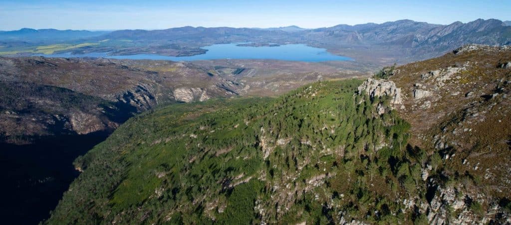
Viewpoint from a helicopter showing a mountain covered in invasive pine species in the Cape Town region of South Africa. The water supply reservoir can be seen in the distance. Photograph courtesy of Roshni Lodhia and The Nature Conservancy.

As communities around the globe deal with water scarcity, new ideas on conserving aquatic resources within watersheds become more important. In Cape Town, South Africa, The Nature Conservancy and its partners instigated a radical plan that, at first glance, appeared counterintuitive to many. Back in 2018, Cape Town was suffering the effects of a years-long drought and was dangerously close to approaching “Day Zero”, when the city’s water was expected to run out. This was a wake-up call for the four million residents, the city’s leaders, and conservation groups: water is not an infinite resource. There is only so much of it, and when it’s gone, it’s gone. So, the question became, can we restore the region’s watersheds (known locally as catchments), thereby protecting the aquatic resources and mitigate any future periods of water scarcity? The Greater Cape Town Water Fund was launched as a potential answer to that question. 

Some options for generating new sources of water included constructing desalination plants and initiating groundwater exploration to locate any new sources of untapped groundwater. However, both of those ideas were incredibly expensive, and, in the case of groundwater exploration, might not lead to any more water for the Greater Cape Town region. So scientists with The Nature Conservancy looked to the land, and the plant communities living on it, and realized that thousands of trees across an area over 101,270 acres in size were invasive species. These trees, primarily eucalyptus and non-native pines, were soaking up far more water than the native trees. Now, tree cover is usually a sign of a healthy watershed: trees capture, store, and filter rainwater. However, in Cape Town, the invasive trees were capturing far more water than usual, which meant far less water was reaching the rivers and making its way into the dams that provided the community with water. 

So, what to do about it? A team was assembled from individuals working with CapeNature, Cape Town’s Volunteer Wildfire Servies (locally known as “flamebusters”), the Greater Overberg Fire Protection Association, Fynbos Trust, the Overberg District Municipality, and The Nature Conservancy. Together, this collective decided to manually remove trees in areas they could reach, and use controlled burns to clear the more mountainous, hard-to-reach areas. Scientists estimated that clearing the water-hogging invasive trees would recover up to two months of the region’s yearly water supply, and only cost a tenth of what the alternatives would cost. Today, The Greater Cape Town Water Fund is pleased to announce that the project is working! Remember that 101,270 acres of invasive trees that was mentioned earlier? Well, that’s the size of the area that has been cleared of invasive trees via controlled burns and manual removals! Over 37 billion liters, or 9.5 billion gallons, have been restored per year into the streams and rivers that flow into the region’s dams. In order to keep this momentum going, the Cape Water Performance-Based Bond was launched in April 2026 to ensure millions in essential funding for the Greater Cape Town Water Fund for many years to come. The Nature Conservancy in South Africa will serve as the implementation agent for the bond, and they believe that both the Water Fund and bond can serve as blueprints for innovative ways to tackle water resource challenges in the future.

#WatershedHealth #InvasiveSpeciesManagement #CapeTown #TheNatureConservancy #WetlandWednesday #TheSwampSchool
Posted on — Leave a comment

North Carolina’s Weird and Wonderful: Carolina Redhorse

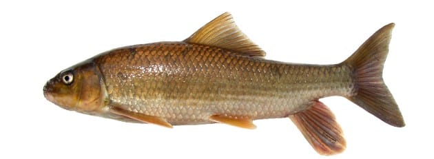
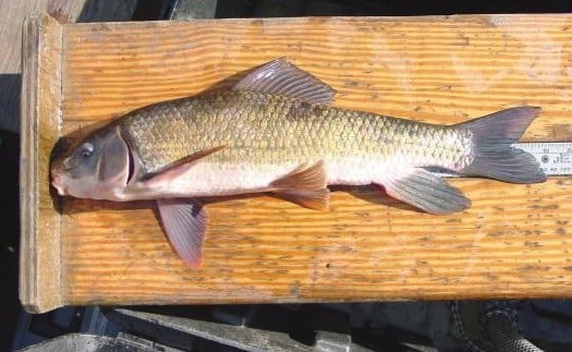
Holotype specimen of Moxostoma carolina, the Carolina Redhorse. Photograph by B.H. Tracy.

Another back-to-school season is upon us, and it’s the end of the month, which means it’s time for a North Carolina’s Weird and Wonderful article focusing on a species of fish! Why? Well, because fish swim in schools, so it all adds up. As I did some reading to find an interesting fish to talk about, it turns out North Carolina officially gained a new aquatic species this year: the Carolina Redhorse, Moxostoma carolina. I always learn so much about the wildlife that live in our state when I write these articles, and until fairly recently, I had no idea that North Carolina is a biodiversity hotspot for the fish genus Moxostoma. This is a fish genus that comprises many different kinds of sucker fish, of which the Carolina Redhorse is one.

Moxostoma species are ray-finned fish within the Catostomidae, or sucker fish, family. The genus name is Greek in origin, with stoma meaning mouth and moxo coming from the Greek word myxo, meaning mucus or slime. Sucker fish are bottom-feeders, using their sucker-like mouths to vacuum detritus, small molluscs, and aquatic insects from the beds of streams and rivers. Many species within this genus are large, strong fish, which is most likely where the “horse” portion of their moniker comes from.  Redhorse species often have brightly colored scales in shades of red and orange, hence the “red” portion of their common name. The species now officially known as the Carolina Redhorse is only found in North and South Carolina, thus far the singular member of the Moxostoma genus that only resides within those two states. Carolina redhorses are incredibly rare, and are present in run-of-river reservoirs and streams in the Piedmont region of both states.

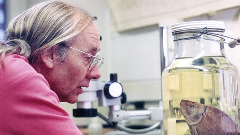
Dr. Robert E. Jenkins in his lab with a preserved fish specimen. Photograph courtesy of Roanoke College.

Specimens of this species were first collected in 1961 from Mill Creek in the Yadkin-Pee Dee River basin in North Carolina. It wasn’t until the 1990s that Dr. Robert E. Jenkins, an ichthyologist (a person who studies fish) who specialized in the Catostomidae family, recognized that the specimens represented a new, as-yet-undescribed species. He collected data on this new species for decades, but passed away in 2023 at the age of 83 before being able to publish his research and make it official. In a scientific article published this year in the journal Zootaxa, a group of ichthyologists have finally officially described the new species, posthumously attributing the majority of the research and credit to Dr. Jenkins. A beloved professor at Roanoke College in Salem, Virginia, Dr. Jenkins shared his love of fish with his students for over forty years, and inspired many young people to go into the ichthyology field.

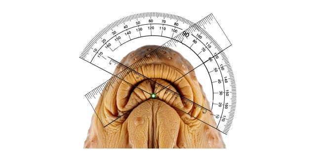
Example of how the lower lip angle is measured on Carolina Redhorse specimens. Photograph by J.L. Bissette and S.A. Smith.

Now, you might be thinking, a fish is a fish is a fish. How in the world can we know that some preserved specimens in jars in the Ichthyology Collection of the Research and Collections Division of the North Carolina Museum of Natural Sciences are in fact a new species of sucker fish? I’m glad you asked! It’s time to break out the calipers and measure the lower lip angle of some pickled fish! Isn’t science marvelous? Carolina redhorse fish have a lower lip angle of 117° falling within the 98-140° range. In addition, they can have 11-13 circumpeduncle scales, which are the scales that form a complete ring around the fish’s tail right before the tail fin. The holotype specimen, which is the specimen all Carolina Redhorse fish will be compared to, has 12 of these scales. Differences in the coloration and patterning of fleshy nodules on the face of the holotype and other specimens also helped distinguish it from other Moxostoma species. Driving the point home was genetic testing, which confirmed that the Carolina Redhorse was a genetically distinct species. 

So, researchers now know this species exists, that its lower lip angle is important, and that close attention should be paid to the scales at the base of the tail and the fleshy bits on the face. What else do we know about the Carolina Redhorse? Not a lot, as it turns out. Adults grow to be large fish, ranging anywhere in size from a single foot to almost two feet in length, and color wise range from brown to copper orange. Ichthyologists hypothesize, based on morphological (shape, size, and structural) characteristics, that adults spawn in the spring from late April to early May on gravelly shoals in larger streams, but thus far spawning behavior has not been observed in the wild. Juvenile forms are very rare in research collections, perhaps due to the young fish moving into smaller, more shallow streams, which can be more difficult for researchers to sample. Similarly, adults are thought to congregate in larger, deep pools in rivers and large streams, which can only be sampled via boat electrofishers. Thus, ichthyologists rarely encounter Carolina Redhorses when sampling streams and rivers within their limited range. 

Carolina Redhorse. Photograph courtesy of the North Carolina Chapter of the American Fisheries Society and the US Fish and Wildlife Service.

Scientists with both the North Carolina Wildlife Resources Commission and the North Carolina Museum of Natural Sciences are working together to survey streams and rivers for these fish; PIT tag them with small, coded microchips; and release them back into the water. The hope is tracking their movements will provide biologists with more data on their population size, location, and maybe even spawning behavior. One day, breeding programs may be established to rear these fish in captivity, give young ones a headstart, and then release them back into the wild to boost their numbers. If there’s one thing that can be taken away from the Carolina Redhorse’s story, it’s this: scientific research is a team effort, often spanning decades. And the work isn’t over: this story is still being written, so the Carolina Redhorse is going to need more passionate ichthyologists, stream ecologists, and conservationists to continue unlocking their mysteries.

#CarolinaRedhorse #MoxostomaGenus #Ichthyology #NCMNS #NCWRS #NCAFS #USFWS #RoanokeCollegeVA #DrRobertEJenkins #NorthCarolinasWeirdandWonderful #WetlandWednesday #TheSwampSchool
Posted on — Leave a comment

Where Growth Meets Conservation: Preserving the Neuse River Lowgrounds

The Neuse River in the Neuse River Lowgrounds. Photograph courtesy of the Triangle Land Conservancy and the Johnston County Report.

Johnston County, North Carolina, is one of the state’s fastest growing counties, which means in addition to attracting industries, small businesses, and new residents, the county has to balance protecting its natural resources and green spaces, too. To that end, Johnston County contributed a portion of the funds that allowed the Triangle Land Conservancy to purchase 602 acres along the Neuse River in July of 2026. This large tract of land includes more than two miles that is right alongside the river, more than 400 acres of wetlands, two oxbow lakes, and some mature stands of bald cypress trees. This adds to the more than 1100 acres of wetlands, mature forests, prime wildlife habitat, and historic farmland that Johnston County and Triangle Land Conservancy purchased earlier in 2026. All of these tracts of land are located near the I-95 corridor and had been under an increased development pressure. Johnston County Commissioners, though, recognized the importance of preserving the rural character of the county while also providing for new outdoor recreation activities, such as fishing, hiking, and camping, in areas the general public previously could not access.

The Gar Gut Mashes, as this newest piece of acreage is locally known, resides within the Neuse River Lowgrounds, which conservationists identified decades ago as one of the natural areas within the greater Triangle region that was a high priority for preservation. Some of the last remaining stands of old-growth bottomland forests in the area reside in the southeastern portion of Johnston County. About 500 acres of this new addition fall within a Natural Heritage Area, which are areas the state of North Carolina recognizes as being of special biodiversity significance. An important bird habitat, the Neuse River Lowgrounds are home to many avian species, among them great blue herons, Swainson’s warblers, and even the Mississippi kite, a rare species to spot in North Carolina. Black bears, wild turkeys, and white-tailed deer also reside in the Gar Gut Mashes, highlighting the region as important habitat for many wildlife species native to North Carolina.

Formerly, the Gar Gut Mashes was part of a large tract of land owned by the Massengill family. For generations, the Masengill family was the steward of this beautiful natural resource, spending days hiking, fishing, and hunting in its forests and along the Neuse River. Now, they are pleased to know that the wild space their parents and grandparents enjoyed will now be protected for future generations. It was due to their generosity and the combined donated funds from the North Carolina Land and Water Fund and Johnston County that the Triangle Land Conservancy was able to purchase and protect this tract of land. While not open to the public yet, the Gar Gut Mashes is already giving back to the community, as its extensive floodplain and wetlands naturally filter runoff and reduce flood impacts for towns further downstream by storing and slowly releasing water. The hope is that more valuable habitat within the Neuse River Lowgrounds is preserved and protected, rather than developed, for the benefit of all North Carolinians.

#NeuseRiver #TriangleLandConservancy #LandConservation #WildlifeHabitat #Wetlands #JohnstonCountyNC #WetlandWednesday #TheSwampSchool
Posted on — Leave a comment

Okefenokee National Wildlife Refuge Is Now a World Heritage Site

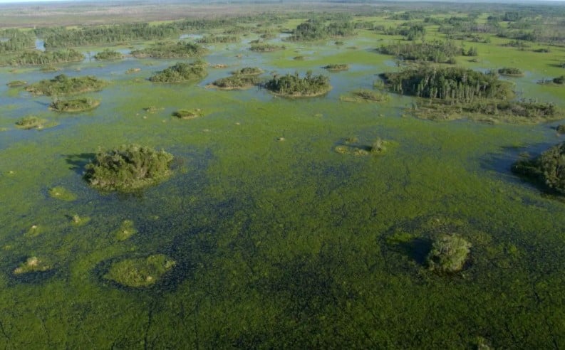
Aerial view of a flooded wetland with green algae and scattered, shrub-covered islands across the landscape.

On July 25, 2026, UNESCO formally added Okefenokee National Wildlife Refuge to its World Heritage List. This marks the first site managed by the U.S. Fish and Wildlife Service to be placed on this prestigious list, and reflects how important the Okefenokee Swamp and surrounding forests and pine savannas are. In their official remarks on why this refuge was awarded this distinction, the World Heritage Committee repeatedly emphasized the critical habitat areas of Longleaf Pine Savanna, and the fact that the refuge is a global biodiversity hotspot. In addition, the land is of great importance to indigenous groups, particularly members of the Muscogee (Creek) Nation, and Okefenokee Swamp was designated as a Wetland of International Importance under the Ramsar Convention in 1971. Having one of its wildlife refuges added to the World Heritage Site list is a huge honor for the United States and the generations of people who have helped preserve and care for the habitats within.

The history of the Okefenokee National Wildlife Refuge (ONWR) began in 1937, when an Executive Order signed by President Franklin D. Roosevelt established it as such. In 1974, 87% of it was designated a National Wilderness Area under the Eastern Wilderness Areas Act, which amended the original Wilderness Act of 1964 to include wilderness areas that had been influenced by man, and not just pristine, old-growth forests that had never been logged or managed in any way. Managed by the U.S. Fish and Wildlife Service, ONWR is currently protected via several pieces of legislation, among them the National Environmental Policy Act, the Archaeological Resources Protection Act, and the Endangered Species Act. Spanning over 400,000 acres, the refuge is of a large enough size that its key ecological processes, such as fire and hydrology changes, are able to function as normal, naturally managing the landscape as has been done for thousands of years. Approximately 27,676 acres of the property are home to the longleaf pine savanna habitat, which historically covered around 90 million acres of the southeastern United States, but now only about 3% of this habitat remains in existence. Longleaf pine savannas are unique ecosystems in and of themselves, hosting a diverse concentration of plant and animal species, including the red-cockaded woodpecker, gopher frog, and hairy rattleweed.

One of the more fascinating, but less well-known aspects of the Okefenokee National Wildlife Refuge, is that it is likely the world’s largest freshwater, subtropical peat bed. Peat is a natural carbon sink, thus peat beds around the world play an important role in storing carbon. When peat beds are destroyed, the carbon is released, which contributes to rising global temperatures. In turn, that increase in temperature results in climate changes across the globe, which often result in more severe weather events such as hurricanes and drought. As the Okefenokee peat bed is still intact, it is playing a huge role in carbon storage, water storage, and water filtration for the whole region. Its subtropical nature also makes it unique, as most peat habitats are found in cooler climates at higher latitudes.

In 2025, it was announced that The Conservation Fund had purchased a proposed mining site adjacent to the Okefenokee National Wildlife Refuge. This marked the end to a years-long battle to protect the Okefenokee, as it was unclear exactly what impact withdrawing 1.44 million gallons of water per day from the underlying aquifer for mining operations would have on the swamp. One can assume, though, that reducing the amount of water available to the swamp ecosystem would have left portions of the refuge drier than normal. In turn, the usual wildfires that occur on site would burn hotter and potentially spread over a large portion of the landscape. However, now that the mining threat has passed, and the UNESCO World Heritage List has recognized the Okefenokee National Wildlife Refuge, the hope is that more resources will be dedicated to managing and preserving this spectacular natural resource for future generations to enjoy. In their announcement of its addition to their list, the World Heritage Committee expressed the hope that a formal buffer zone along the entire perimeter would be established and enforced, and that the historical, cultural, and spiritual needs of the Muscogee (Creek) Nation would be addressed in any updated conservation plans for the property. So, the next time you find yourself in southeastern Georgia or northeastern Florida, consider taking a day trip to the Okefenokee. I guarantee you’ll understand why its natural and cultural significance are now recognized worldwide.

#OkefenokeeSwamp #OkefenokeeNationalWildlifeRefuge #WorldHeritageSite #RamsarWetlandofInternationalImportance #LongleafPineSavanna #Conservation #WetlandWednesday #TheSwampSchool
Posted on — Leave a comment

Prairie Pothole Duck Habitat Under Threat

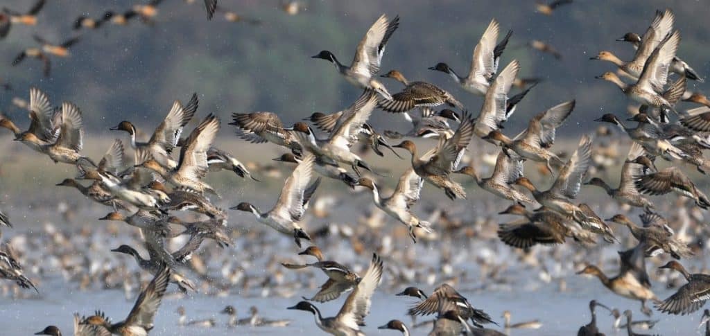
Pintail ducks taking flight in the Prairie Pothole region of the U.S. Photo courtesy of Field & Stream and Adobe.

In July of 2026, the U.S. Fish and Wildlife Service released an online notice stating that it “found it necessary to withdraw the [May 13, 2024] rule” which “established regulations pertaining to wetland easements.” The 2024 rule codified the process of requesting providing drain tile setbacks as part of the National Wildlife Refuge System’s wetland easements program. Subsurface agricultural drainage is a process by which poorly drained, often wetland, soils are drained in an effort to improve the soil’s aeration. This, in turn, can turn land that previously could not be farmed into usable farmland. When drainage happens next to a wetland, it reduces the hydroperiod, resulting in temporary or even permanent damage to the wetland habitat. Drain tile setbacks helped reduce this risk, by requiring drainage to happen a certain distance away from wetlands. In an effort to conserve wetland habitats, the Wetlands Loan Act of 1961 was passed. This act provides funding for the purchase of wetland easements, so that landowners are compensated for turning over wetland habitat to the National Wildlife Refuge System as a conservation easement.

In the Prairie Pothole Region of the United States, prairie pothole wetland habitats are critical breeding grounds for thousands of native ducks. The Wetlands Loan Act provided funding for the Small Wetlands Acquisition Program (SWAP) through the Duck Stamp program; for decades, money coming from the purchase of federal duck stamps was used to fund wetland conservation easements, many in the so-called “Duck Factory of North America”. The National Wildlife Refuge System not only manages the wetlands within the easements, but it also placed restrictions on how nearby land not included in the easements could be used. This was to make sure that changes to the surrounding landscape did not negatively impact the protected wetlands; requiring drain tiles be placed a certain distance away from wetlands was one of the restrictions.

The U.S. Fish and Wildlife Service rescinding the May 2024 drain tile setback rule means that many prairie potholes are at an increased risk of drying up, which in turn could lead to a 20-50% reduction in the duck breeding capacity of these critical habitats. This move has created an outcry amongst conservationists, especially duck hunters, as they have worked for decades to protect prairie potholes and other important breeding grounds for waterfowl and other migratory birds. Ducks Unlimited, an organization dedicated to conserving and restoring wetland habitats across the country, has decried this decision as well, stating that the May 2024 Rule “protects critical waterfowl habitat, provides certainty for landowners-through science-based setback plans, and preserves the integrity of conservation easements that have delivered enormous benefits for wildlife and hunters alike.” When combined with recent rollbacks of the Endangered Species Act’s ability to protect habitat, waterfowl and other migratory bird habitats are at a heightened risk of disappearing. The U.S. Fish and Wildlife Service opened a public comment period on this topic on June 24, 2026, with the commend period ending on August 7, 2026. If you would like to see prairie potholes and other wetland habitat receive continued protections, and would like the May 2024 Rule to remain in place, consider submitting a formal public comment. Public outcry may be the only thing that keeps this waterfowl-rich region protected for future generations of birders, duck hunters, and other conservationists.

#Wetlands #PrairiePotholes #DuckHabitat #Waterfowl #Conservation #USFWS #MigratoryBirds #EnvironmentalPolicy #WetlandConservation #WetlandWednesday #TheSwampSchool
Posted on — Leave a comment

North Carolina’s Weird and Wonderful: Sassafras

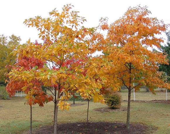
Sassafras albidum tree thicket in the fall. Photo courtesy of P.W. Hatcher and the North Carolina Extension Gardener Plant Toolbox.

Another month is over, which means it’s time for a new edition of North Carolina’s Weird and Wonderful! Over the past few years, July has become a very plant-heavy month for me, primarily due to the Cullowhee Native Plant Conference. Those who know me well can tell you that I’m not a botanist; in fact, I’m pretty sure I told my favorite biology professor in college that botany wasn’t for me. With age comes wisdom, as they say, so I’ve been trying to remedy this rather large gap in knowledge by learning from my colleagues, taking workshops and guided hikes, and, of course, purchasing and reading a lot of field guides (I know there are apps for that now. But the only way you will get me to give up my guidebooks is by prying them from my cold, dead hands). So, in honor of the Cullowhee Native Plant Conference turning over a new leaf and becoming the Southeastern Native Plant Conference, and to increase my botanical knowledge by one species, this month’s weird and wonderful focus is on the sassafras tree, Sassafras albidum. 

Full disclosure: I primarily picked this tree because it is fun to say. Sassafras. What a wonderful word! It is thought that the word “sassafras” comes from the Spanish word “sasafras”, which itself may have been a word that sounded similar to a now-lost-to-time indigenous term for the plant. The sassafras tree is common throughout the Eastern United States and prefers full sun to light shade. Saplings that find themselves shaded out by larger, faster-growing plants will probably die off, but young trees that are able to get a foothold in sunny patches will begin to thrive. A large taproot makes it difficult to transplant a sassafras sapling from one spot to another, and this species has the habit of spreading via suckers to form sassafras thickets.

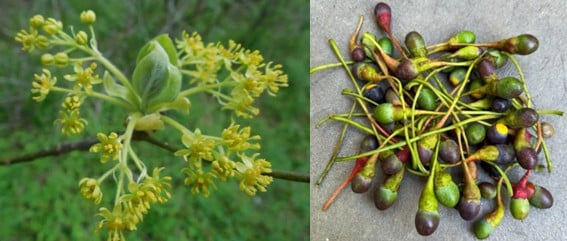
Sassafras tree flowers, left, and the ripe and unripe fruit, right. Photos courtesy of Flower of the Carolina.

In early spring, since this species is dioecious, male and female flowers appear on different trees. Fruits will only form on female trees if there were male trees (and pollinators) somewhere in the vicinity. The fragrant flowers do attract a wide variety of pollinators, including native bees, wasps, and flies, and the foliage is fodder for both the imperial moth caterpillar and the spicebush swallowtail caterpillar. Dead stems, when left standing, provide shelter in which native bees overwinter. The fruits are enjoyed by many birds and mammals, including Eastern bluebirds, wild turkeys, pileated woodpeckers, black bears, and squirrels; the bark and twigs are consumed by several mammals, with beavers, in particular, enjoying all the woody bits sassafras has to offer.

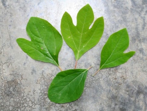
Sassafras tree leaves, demonstrating the left and right-handed mitten leaf shape, the three-fingered leaf shape, and the egg leaf shape. Photo courtesy of the Municipality of Princeton, NJ.

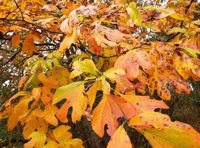
One of the weird and wonderful characteristics of this tree is its leaf shape. Sassafras leaves are often described as mittens, and one could say this tree is ambidextrous, as it produces both right and left-handed mittens. Other leaf shapes include a three-fingered version and a smooth egg shape. In the fall, sassafras leaves turn brilliant shades of red, orange, yellow, and even purple, often standing out amongst the rest of the fall foliage across the autumnal landscape. Mature bark is red-brown in color and was historically used to make a vibrant, orange dye for wool products.

This is where things get a bit weird. The bark, leaves, twigs, and roots of sassafras had been used for medicinal purposes for centuries. Indigenous tribes brewed teas to ease or cure numerous ailments, among them rheumatism, diarrhea, the common cold, fevers, and kidney problems. During the early years of European colonization, sassafras tea was exported out of North America in large quantities, due to the lore surrounding this tree’s extract as a cure-all wonder drug. More recently in time, safrole, the main component in sassafras oil extracted from the bark, was used as a flavoring agent for root beer, chewing gum, and as an additive in Cajun spices. Sounds pretty wonderful, right? Well, in the 1960s, researchers found that safrole, when given to mice and rats both orally and via subcutaneous injection, resulted in the development of liver tumors. As a result, safrole has been deemed a weak hepatocarcinogen for humans, and is banned by the U.S. FDA for use in food. Recent research, though, has shown that safrole has potential as an antimicrobial agent; as a potential herbal supplement for use as an antidiabetic; and as a cytotoxin used to treat cancer cells. The scientists who conducted the study, while optimistic, caution that more work is needed, especially considering the rodent study results from the middle of the 20th century.

Sassafras tree in all its autumnal glory. Photo courtesy of Flower of the Carolina.

So…is safrole good or bad? It’s entirely possible that, like many other plants people assumed had healing properties throughout our past, sassafras didn’t actually contribute anything positive. It’s also plausible that the extract was able to treat some ailments, but might have also caused further illness that was never linked back to sassafras usage at the time. Perhaps whether safrole leans on the side of healing or not has to do with how the sassafras oil is collected from the tree, and then how it is subsequently treated, before being utilized as a flavoring agent or medicinal additive. Whatever the case may be, I would argue that this uncertainty adds to the weird and wonderful mystique surrounding the sassafras tree. Besides, with adorable mittens and gorgeous fall colors that can be forever preserved as a vibrant wool dye, who wouldn’t want this lovely tree in their backyard? 

Posted on — Leave a comment

Southwest Florida Gains Powerful New Tool for Wetland Restoration and Water Management

The following blog post is a summary of the article “WET Expands to Southwest Florida” by Dr. Paul Gray and Audubon Florida, published on June 4, 2026. To read the original article, which originally appeared in Audubon’s State of the Everglades Spring 2026 Report, click here.

Image courtesy of Audubon Florida and Dr. Paul Gray.

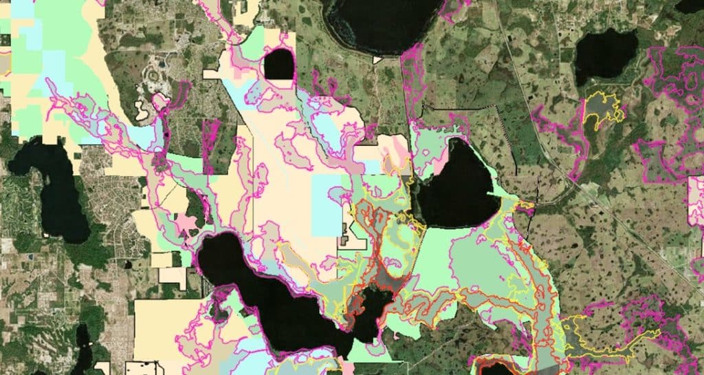
Audubon’s Wetland Evaluation Tool (WET) is an interactive, GIS-based mapping resource that helps identify locations where surface water can be stored naturally while also highlighting opportunities for wetland restoration and aquifer recharge. After demonstrating its value in the Central Florida Water Initiative and the Lake Okeechobee watershed, the tool is now being expanded into Southwest Florida. The expansion reflects a growing need for innovative approaches to water management in one of Florida’s fastest developing regions. As development continues to reshape the landscape, natural systems that once captured and stored water have been replaced by roads, pavement, and extensive drainage networks. The WET is intended to help restore some of the landscape’s natural ability to retain water and improve long-term watershed resilience.

Historically, Florida’s wetlands, floodplains, and soils provided a natural buffer against both floods and drought by storing water during wet periods and gradually releasing it over time. Modern drainage infrastructure is designed to move water off the landscape quickly, reducing this natural storage capacity and increasing the severity of drought conditions. Rapid stormwater releases can also create environmental problems by abruptly changing salinity levels, carrying excess nutrients into waterways, and contributing to harmful blue-green algae blooms. These challenges are becoming more significant as Southwest Florida experiences increased coastal flooding alongside more frequent and intense wildfires. The continuing loss of wetlands has made restoring natural water storage systems an increasingly important priority for the region.

The need for improved water management is underscored by the estimated loss of more than 30,000 acres of wetlands in Collier and Lee counties since 1996. By expanding the WET into Southwest Florida, Audubon aims to provide local governments, water management districts, and private landowners with a practical tool for identifying the most effective locations for restoration projects. The mapping system can help guide investments toward projects that offer the greatest benefits for water storage, aquifer recharge, and ecosystem health. It will also play an important role in shaping the Corkscrew Watershed Initiative restoration plan by helping prioritize projects throughout the watershed. These efforts are expected to strengthen the long-term health of the region’s wetlands while supporting important natural areas such as Audubon’s Corkscrew Swamp Sanctuary.

#AudubonFlorida #WetlandEvaluationTool #WetlandRestoration #StormwaterManagement #NatureBasedSolutions #WetlandWednesday #TheSwampSchool