The proposal promises less paperwork, but it could turn one wetland delineation into two boundary investigations—and the agencies have not published a method for drawing the second boundary.
By Marc Seelinger, SPWS
EPA and the Department of the Army published a new WOTUS proposal today that could remove most intermittent streams—and potentially large portions of many wetlands—from federal Clean Water Act jurisdiction.
It is being presented as deregulation. The agencies predict fewer federal permits, lower costs, and greater certainty. The Army has placed the effort under its “Building Infrastructure, Not Paperwork” initiative.
But there is a serious problem: the agencies have not provided a credible method for applying either of the new jurisdictional tests.
The proposal may reduce federal jurisdiction. It does not reduce the work needed to prove where jurisdiction ends. In practice, it could create more investigations, more disputes, and a new nationwide backlog of Corps jurisdictional-determination reviews.
That helps no one—not even developers.
The Supplemental Notice of Proposed Rulemaking was published September 9, 2026, at 91 FR 57284. Comments are due October 9 under Docket No. EPA-HQ-OW-2025-0322. Read the published proposal.
Two new alternatives
The proposal adds two alternatives to the WOTUS rule proposed in November 2025. Neither is current law.
The first would generally limit “relatively permanent waters” to perennial waters. A stream would need standing or continuously flowing water every day of an ordinary year. One ordinary interruption lasting up to 30 consecutive days could be allowed.
The word one creates an immediate problem. A stream that is dry once for 30 days could qualify. A stream that is dry twice for one day each could fail—even though the second stream contains water on 28 more days during the year.
That is a legal bright line, not a scientifically credible measure of stream permanence. The agencies acknowledge that there is no precise, scientifically grounded, nationally consistent basis for the 30-day limit.
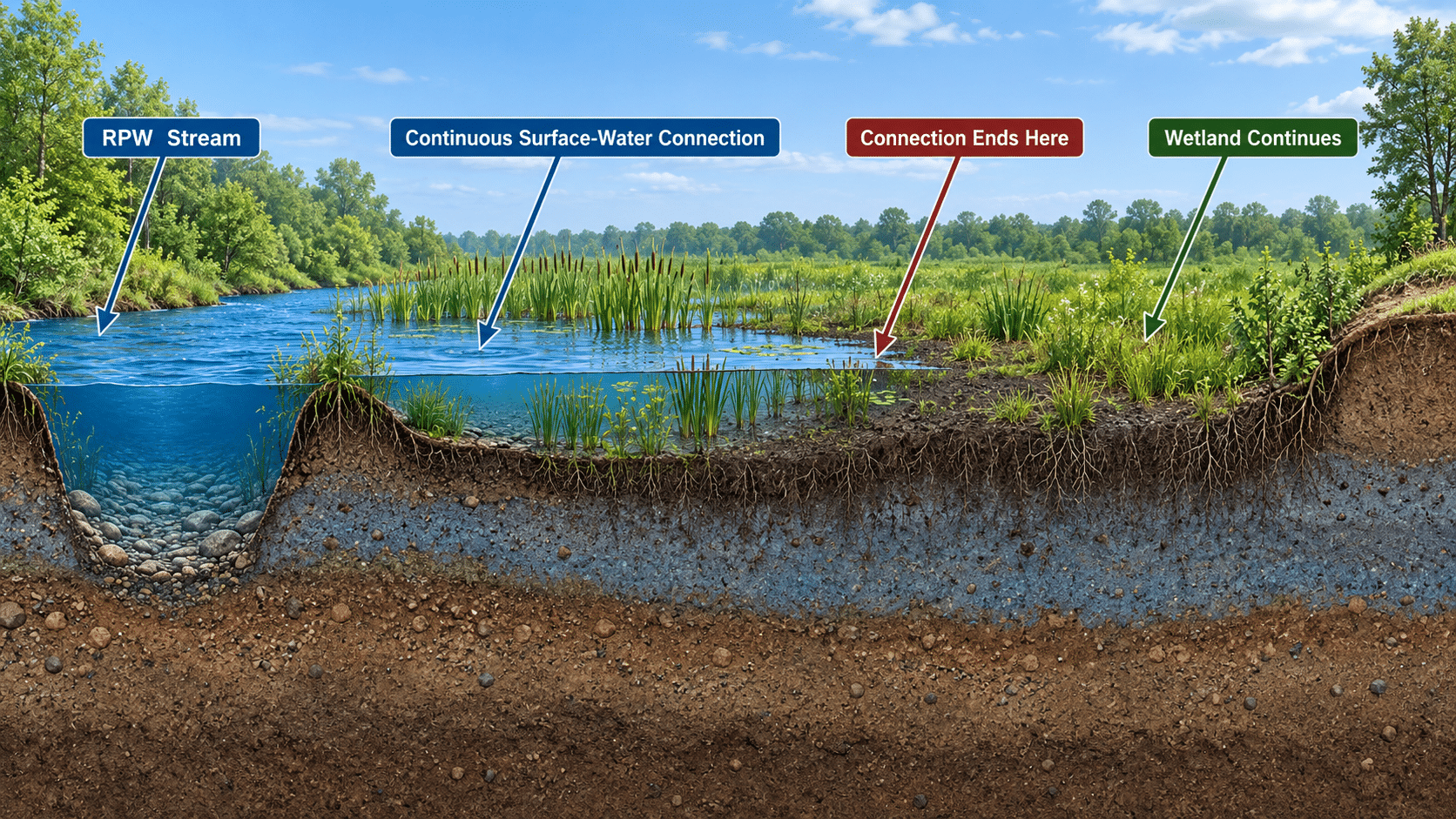
The second alternative concerns wetlands. It would require perennial surface water within a wetland to be continuously connected to surface water in a jurisdictional water. The connection must make it difficult to tell where the jurisdictional water ends and the wetland begins.
Only the connected portion of the wetland might be federally jurisdictional. This could create two separate boundaries on the same property: the scientifically delineated wetland boundary and a new federal boundary somewhere inside it.
The agencies anticipate that most intermittent streams would fail the first test. They also anticipate that a majority of wetlands currently regulated as adjacent wetlands would fail the second because most wetlands do not contain perennial surface water.
There is no published procedure for making these decisions
The Swamp School reviewed the proposal, existing Corps and ERDC procedures, and relevant scientific literature. We found useful methods for studying streamflow duration and wetland connectivity. We did not find a validated procedure capable of answering the exact legal questions the agencies propose.
A one-time site visit cannot establish whether water was present every day of an ordinary year. Finding a dry stream does not reveal when it dried, whether this was its first or second interruption, or whether the cause was ordinary or anomalous.
Streamflow Duration Assessment Methods can estimate whether a stream is typically ephemeral, intermittent, or perennial. They do not reconstruct a day-by-day record or distinguish one interruption from two. EPA scientists have explained that streamflow duration exists along a continuum and that classifications require regional calibration and treatment of uncertainty. Fritz et al. (2020)
Maps, models, and satellite imagery cannot fill the gap. Tree canopy, shadows, narrow channels, shallow water, cloud cover, mapping errors, and time between images prevent them from proving daily surface-water conditions at property scale.
For wetlands, the problem is harder. Existing delineation methods identify the boundary between wetland and non-wetland. They were not designed to locate a second boundary inside one continuous wetland based on the daily persistence of surface water.
Published connectivity studies have required water-level instruments, repeated site visits, precipitation records, channel inspections, and elevation data. That research is valuable, but it is not a national jurisdictional-boundary protocol. McDonough et al. (2015)
The proposal nevertheless suggests that a landowner could identify the connected portion of a wetland by observation or “the naked eye.” That claim is difficult to reconcile with a test requiring proof of perennial water, ordinary conditions, drought exceptions, and no more than one qualifying interruption.
Why developers should be concerned
The agencies assume narrower jurisdiction will mean fewer Section 404 permits and lower costs. That may be true after a property owner obtains a defensible non-jurisdictional decision. The unanswered question is what it will cost—and how long it will take—to get that decision.
A developer cannot finance and design a project based on a national estimate that “most” intermittent streams or wetlands will be excluded. The developer needs a reliable answer for the specific property. Lenders, purchasers, engineers, local governments, and investors may also demand Corps confirmation.
Under the new alternatives, consultants may need to document streamflow over time, distinguish ordinary conditions from drought, investigate separate interruptions, map perennial surface water inside wetlands, and defend an internal jurisdictional boundary.
That work occurs before anyone knows whether a permit has been avoided.
Delays at that stage can affect purchase contracts, financing, engineering plans, local approvals, construction schedules, and mitigation decisions. A theoretical reduction in jurisdiction has little value if the project waits months for an answer that no published method can reliably produce.
Why the Corps backlog could grow
Without a national procedure, each Corps district—and potentially each project manager—will have to decide what evidence is sufficient.
How many site visits are enough? How long must monitoring continue? What water depth counts? Where should sensors be placed? Which drought category controls? What happens when field observations conflict with maps or imagery? How is the internal wetland boundary surveyed?
Different applicants will submit different evidence. Corps reviewers will request additional information, resolve conflicting indicators, and prepare decisions capable of surviving administrative appeals and litigation.
The likely result is more case-by-case analysis and more requests for AJDs. The Corps may eventually process fewer permit applications, but it could first inherit a larger and substantially more complicated jurisdictional-review workload.
This is paperwork moved to the front of the project, where delay is often most expensive.
A rule that helps no one
Developers do not benefit from an uncertain and potentially slower approval process. The Corps does not benefit from being handed new tests without validated procedures or additional resources. Consultants do not benefit from inconsistent district expectations. States and Tribes may inherit responsibility for excluded waters without uniform programs or additional capacity. Environmental interests could lose federal protections without gaining a clear or scientifically defensible boundary.
The agencies should withdraw both alternatives in their current form.
Before adopting either one, EPA and the Army should disclose any technical review conducted by Corps districts or ERDC, complete a geographically representative multi-district pilot study, quantify the expected effect on AJD workloads and processing times, and demonstrate acceptable accuracy and inter-observer reproducibility.
Any resulting methodology should be published for public comment before the jurisdictional standard is finalized—not developed afterward through inconsistent case-by-case decisions.
This is not an argument for broader federal jurisdiction for its own sake. It is an argument for a rule that can actually be implemented.
If the administration wants less regulatory burden, it must evaluate the entire process. A rule that excludes more waters but requires longer, costlier, and less predictable investigations to identify them is not meaningful deregulation.
It is a regulatory backlog waiting to happen.
Comments must be received by October 9, 2026. Identify Docket No. EPA-HQ-OW-2025-0322 and submit comments through Regulations.gov.