Why We Are Objecting
EPA and the Army say the new alternatives could provide a clearer jurisdictional line. In the field, they may create more uncertainty, more documentation, and longer Corps reviews.
EPA and the Department of the Army have added two new alternatives to the ongoing rulemaking over the definition of “waters of the United States,” or WOTUS. If adopted, the first could remove most intermittent streams from federal jurisdiction. The second could divide a single scientifically delineated wetland into jurisdictional and non-jurisdictional portions.
That is a major change in how federal jurisdiction could be evaluated. It is also important to say what this announcement is not: these alternatives are proposals, not current law. They should not be used today as the standard for a jurisdictional determination.
The agencies describe the alternatives as possible bright lines that would implement the Supreme Court’s 2023 decision in Sackett v. EPA. The stated goals include predictability, reduced permitting burdens, and a more durable rule. Those are worthwhile goals. Our concern is that neither alternative is supported by a published method capable of producing consistent, defensible decisions in the field.
The problem is not simply that the proposed standards are narrow. The deeper problem is that they ask landowners, consultants, and Corps project managers to prove highly specific hydrologic facts without supplying the measurement rules needed to do so.
Alternative 1: A perennial-only test for relatively permanent waters
The first alternative concerns “relatively permanent waters,” often shortened to RPWs.
Under the agencies’ November 2025 proposal, a water could qualify as relatively permanent if it contained standing or continuously flowing water year-round or at least during the wet season. The new alternative would remove the wet-season option. A water would generally have to be perennial—containing standing or continuously flowing water every day during ordinary conditions.
The proposal provides two possible exceptions. An anomalous event, such as an unusually severe drought or dry spell, would not necessarily cause the water to lose perennial status. The alternative would also allow one regularly occurring interruption lasting no more than 30 consecutive days during the year.
The word “one” matters. A stream that is dry for one continuous 30-day period could still qualify. A stream that is dry for two separate one-day periods could fail, even though it contains water for more days of the year. The agencies also acknowledge that most intermittent streams would not meet the proposed test.
Why Alternative 1 is not scientifically credible
Streamflow duration is real, measurable, and important. But the published science generally treats perennial, intermittent, and ephemeral flow as regional and multi-year hydrologic patterns. Those patterns vary with climate, geology, watershed position, groundwater inputs, water withdrawals, and weather from one year to the next.
The literature does not establish one national, scientifically meaningful breakpoint at one interruption of 30 days. In fact, the supplemental notice acknowledges that there are no precise, scientifically grounded, nationally consistent time limits supporting that number. Calling 30 days approximately one month may make it easy to write into a regulation, but it does not explain why one 30-day dry period is hydrologically acceptable while two much shorter interruptions are not.
The alternative also creates a proof problem. A field visit shows conditions on the day of the visit. It cannot establish that water was present every other day of the year. Seeing a dry channel does not reveal when the dry period began, how long it lasted, whether another interruption occurred elsewhere in the reach, or whether the condition was ordinary or anomalous.
The tools identified by the agencies do not solve that problem:
- Stream gages provide daily records, but only for a tiny fraction of potentially regulated waters.
- The Corps’ Antecedent Precipitation Tool and the U.S. Drought Monitor provide climatic context; they do not reconstruct daily flow at a particular stream reach.
- Streamflow duration assessment methods can help classify a stream from multiple indicators, but they were not designed to count dry days or distinguish one interruption from two.
- Aerial imagery, national hydrography data, and remote-sensing products are useful screening tools, but their resolution, revisit frequency, canopy limitations, and missing observations prevent them from proving uninterrupted daily flow at parcel scale.
- Sensors can collect better site-specific records, but the proposal does not say how many are needed, where they must be installed, what counts as detectable water, or how missing data should be handled.
Several essential terms are also unresolved. What is the relevant stream reach? Does water in an isolated pool count as standing water for the whole reach? Which 12-month period controls? When does a normal dry spell become anomalous? How should flow affected by a release, withdrawal, beaver dam, or storm pulse be treated?
Until those questions have objective answers, Alternative 1 is not a bright line. It is a collection of case-by-case judgments hidden behind a precise-looking number.
Alternative 2: Drawing a federal line inside a wetland
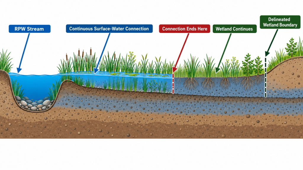
The second alternative would apply an equally strict version of the “continuous surface connection” test to wetlands.
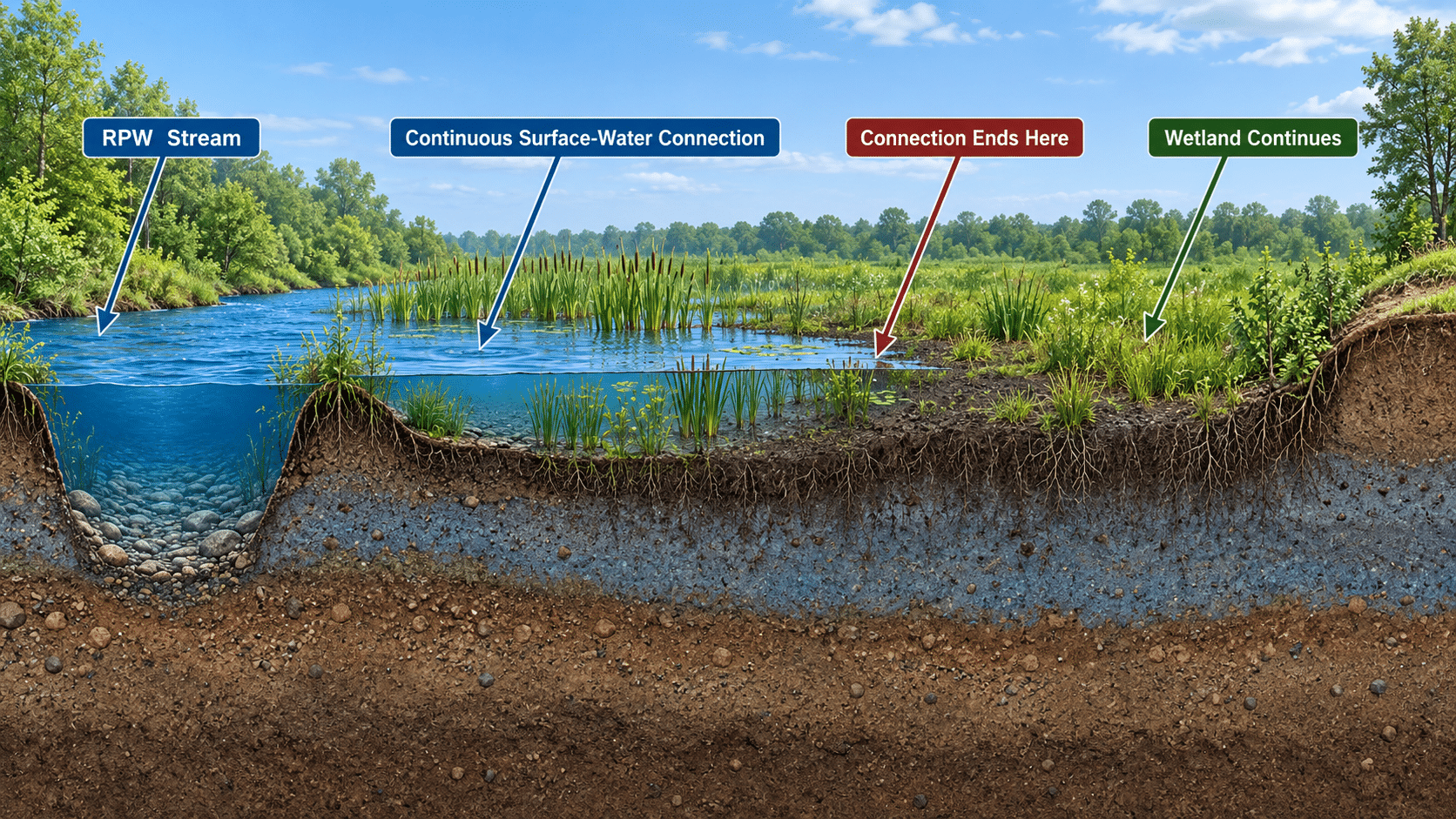
Under this approach, a wetland may need perennial surface water that is continuously connected to a jurisdictional water. The connection would need to make it difficult to determine where the jurisdictional water ends and the wetland begins. The same anomalous-event and single 30-day interruption concepts would apply.
The most consequential part is the proposed treatment of the wetland itself. The agencies suggest that only the portion of a wetland containing the required perennial surface-water connection would be jurisdictional. Federal jurisdiction could end where the perennial surface water “runs out,” even though the scientifically delineated wetland continues farther landward.
That would create two different boundaries on the same site:
- The wetland boundary established under the Corps Wetlands Delineation Manual and the applicable regional supplement.
- A new internal federal jurisdictional boundary based on the extent and duration of surface water.
The land beyond the second line would still be wetland. It could remain regulated under state, Tribal, or local law. But under the proposed federal alternative, it might no longer be WOTUS.
Why Alternative 2 cannot be implemented reliably
No published EPA or Corps manual provides a validated procedure for drawing this internal line. The Corps’ established wetland-delineation methods distinguish wetland from non-wetland using vegetation, soils, and hydrology. They do not divide one continuous wetland into federal and nonfederal portions based on the day-by-day persistence of surface water.
Academic studies can measure when water moves between wetlands and streams. Researchers have used sensors, repeated site visits, detailed elevation surveys, aerial imagery, radar, and satellite data. Those studies are valuable, but they generally produce observations at instrument locations, estimates of inundation extent, or probabilities of connection. They do not produce a stable, survey-ready federal boundary that has been validated across different wetland types and regions.
Wetlands are especially difficult places to draw such a line. Surface water responds to small changes in elevation and may occupy channels, pools, swales, hollows, and depressions. It can disappear at one point while remaining connected by another pathway. The apparent edge can move substantially between seasons and years. Forest canopy may hide shallow water from optical imagery, while many satellite products are too coarse to resolve project-scale conditions.
A one-time “naked eye” observation therefore cannot establish that water was present every day under ordinary conditions. Nor can it determine where that condition ended throughout an irregular wetland. More monitoring might improve the evidence, but the proposal supplies no national requirements for monitoring duration, sensor spacing, water-depth thresholds, survey accuracy, climatic normalization, uncertainty, or conflicting data.
Our objection is not that wetland-stream connectivity cannot be studied. It can. Our objection is that existing research has not been converted into an accuracy-tested, reproducible regulatory procedure for the legal decision the agencies propose.
A rule intended to reduce burden could increase it
Both alternatives could greatly increase the work required to obtain an Approved Jurisdictional Determination.
Alternative 1 would require the Corps to decide whether a stream contained water every day, whether each gap was ordinary or anomalous, whether one or multiple interruptions occurred, and where the relevant perennial reach begins and ends.
Alternative 2 would require a second, case-specific investigation after the ordinary wetland delineation is complete. Each wetland on a property could need its own hydrologic record, internal boundary analysis, supporting imagery, climatic evaluation, and surveyed line. A property with several wetlands could therefore produce several separate mini-investigations.
Without a national method, Corps districts and individual project managers may reasonably reach different conclusions from similar evidence. Applicants are likely to submit larger documentation packages and request more Approved JDs because the legal consequences are substantial. The predictable results are more requests for information, repeat field visits, disputes, appeals, and longer processing times.
That outcome would run directly against the Army’s “Building Infrastructure, Not Paperwork” initiative and the agencies’ stated objective of reducing regulatory uncertainty. Excluding waters from jurisdiction may reduce some permitting obligations, but it does not eliminate the cost of determining whether federal jurisdiction exists in the first place.
What the law does, and does not, require
The Supreme Court held in Sackett that covered wetlands must have a continuous surface connection with a relatively permanent covered water, making it difficult to determine where the water ends and the wetland begins. But the Court did not require a perennial-only stream definition, select a one-period 30-day allowance, or instruct the agencies to draw a separate federal boundary through the interior of a wetland.
Those are policy and technical choices made by the agencies. They therefore need support in the administrative record. A durable rule should show a rational connection between the evidence and the standard, tell the regulated public how the standard will be measured, and give Corps personnel enough guidance to apply it consistently. A number in a regulation is not meaningful notice if no one can reliably determine the facts to which the number applies.
The Swamp School is preparing separate public comments asking EPA and the Army to withdraw both alternatives. At a minimum, the agencies should first disclose any technical review conducted by Corps district personnel or the Engineer Research and Development Center, complete a multi-district pilot study, measure inter-observer reproducibility, and quantify the effects on AJD workloads and processing times. Any resulting methodology should then be published for public comment before the substantive jurisdictional standard is finalized.
What happens next
As of September 8, 2026, the supplemental proposal is on public inspection and is scheduled for publication in the Federal Register on September 9. The 30-day comment period is expected to close on October 9, 2026. Before filing, commenters should confirm the final deadline on the published notice.
The official docket is EPA-HQ-OW-2025-0322. The EPA WOTUS page, Federal Register public-inspection page, and Regulations.gov docket provide the current documents and filing information.
The agencies are right to seek a WOTUS definition that is understandable, legally durable, and practical to administer. But these two alternatives do not yet meet that standard. They replace familiar jurisdictional questions with new ones that are more data-intensive, less reproducible, and unsupported by an established field method.
That is not regulatory certainty. It is uncertainty with a stopwatch and a new line on the map.
This article is for educational purposes and is not legal advice.
#WOTUS #WetlandDelineation #CleanWaterAct #PublicComment #Wetlands #EnvironmentalProfessionals #WetlandWednesday #TheSwampSchool