Posted on — Leave a comment

North Carolina’s Weird and Wonderful: Spiny Softshell Turtle

Illustration of a spiny softshell turtle on a riverbank.

Well, Turtle Month 2025 came to a close last week with World Turtle Day on May 23rd. We learned how to safely help a turtle cross the road: always place them in the direction they are going and never turn them around. We shared our first experiences with turtles, ranging from individuals’ childhood backyards to zoos, nature centers, aquariums, and museums across the globe. The whole world celebrated turtles and tortoises in all their glory! To properly wrap this month up, this edition of North Carolina’s Weird and Wonderful will be on, of course, a turtle: the Spiny Softshell, Apalone spinifera. 

The spiny softshell turtle cannot be confused with any of the other turtle species in North Carolina. Instead of having a hard carapace composed of bone covered with scutes comprised of keratin, this species has a bony carapace covered in tough, leathery skin. The skin often has a texture described as sandpiper-like, and the carapace has well-defined black spots for juveniles and males, while females have indistinct blotches. Overall, these turtles range in color from yellow brown to olive gray, with very long necks and a long, thin nose. Spiny softshell turtles will use this nose as a snorkel to breathe underwater, often burying themselves in the sand and extending it upward towards the water’s surface. The “spiny” part of their name comes from the fact that they have spines, or tubercles, along the front edge of their carapace. This, and the fact that they have patterned feet, help distinguish them from a similar North American species, the Florida softshell turtle. 
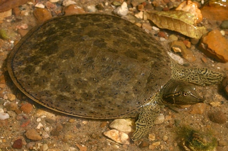
Apalone spinifera, Spiny Softshell Turtle. Photo courtesy of Todd Pierson and Herps of NC.

There are two subspecies of these weird and wonderful-looking turtles in North Carolina. The Eastern Spiny Softshell, Apalone spinifera spinifera, has been found primarily in the French Broad River system in Western North Carolina. The Gulf Coast Spiny Softshell, Apalone spinifera aspera, has been found in all the Atlantic drainage systems south and west of the Cape Fear River. All spiny softshell turtles occur in large streams and rivers that have sandy bottoms or mud bars, in which they can bury themselves. These creatures also enjoy basking on logs and are very strong swimmers; spending most of their time in the water, the few times they are on land, they can move very quickly. Females lay clutches of 12-18 round eggs during the early summer months in nests that are often very close to the water. Usually, the nests are on sand bars or sandy banks, but they have been found in people’s yards on occasion. After approximately 80 days, the hatchlings emerge, measuring 1-1.5 inches across. Carnivorous, these turtles consume aquatic invertebrates, crayfish, fish, and other aquatic critters.

Apalone spinifera, Spiny Softshell Turtle. Photo courtesy of Pierson Hill and North Carolina Wildlife Resources Commission.

While incredibly unique, not much is known about the state of the spiny softshell turtles in North Carolina. Due to this lack of knowledge and their limited range, they are listed as a species of Special Concern in the state. The North Carolina Wildlife Resources Commission, in April of this year, released a statement asking for the public’s help. Anyone who has seen these turtles in the wild is encouraged to submit a sighting report. With the data they collect, the NCWRC is hoping to learn more about their distribution, identify potential areas for future monitoring, and perhaps even identify new populations. So, the next time you are walking along the Cape Fear River or the French Broad River, keep your eyes peeled in areas with sandy banks and sandbars. There could be some spiny softshell turtles buried beneath the water’s surface, using their weird and wonderful nose to snorkel undetected. 

#NorthCarolinasWeirdandWonderful #SpinySoftshellTurtle #TurtleMonth2025 #WorldTurtleDay2025 #TurtleConservation #TurtleSurvivalAlliance #AmericanTortoiseRescue #SwampSchool

Posted on — Leave a comment

Lake Phelps and Pettigrew State Park: History & Nature Intertwined

Illustration of Lake Phelps with three ancient dugout canoes in the foreground and Somerset Plantation in the background in Pettigrew State Park.

Did you know the month of May is Preservation Month in the United States? No, I am not talking about homemade jams and jellies, I am referring to historical preservation. National Historic Sites encompass buildings, battlefields, city blocks, and even whole towns within the U.S. There is even a National Historic Site located outside of our country’s borders all the way in Morocco! As I discussed last year in my blog posts about The Great Dismal Swamp and Jordan Lake, there are many natural spaces within North Carolina that are also home to a rich cultural history. Another such interesting place is Pettigrew State Park.  

Located in Tyrrell and Washington Counties, North Carolina, this state park is primarily composed of Lake Phelps, one of the state’s famous pocosins, also known as Carolina Bays. This pocosin was undiscovered by European settlers until 1755, when two local hunters and adventurers journeyed into the dense forest to find game and scope out promising farmland. One of the men climbed a tree and saw the lake; another, a man by the name of Josiah Phelps, ran into the water, declaring it was to be named after him.  However, the indigenous groups in the region had known about the lake’s existence for centuries prior to this “discovery”. Archaeological research performed in and around Lake Phelps has revealed at least thirty log canoes sunken in the lake, with one being the longest known indigenous dugout canoe in the southeastern United State, measuring 36 feet in length. Another of the canoes is the second oldest in the nation, with radiocarbon dating placing it around 2400 B.C.E. It is hypothesized that the Algonquian tribe would sink their canoes in the shallow water to store and protect them until they came back to the pocosin during the following year. Thousands of other relics have been recovered from in and around the lake, emphasizing the point that the pocosin, and the surrounding forests, have been used for centuries. 

So, what exactly is a pocosin? A pocosin is a unique wetland that has formed due to the accumulation of organic matter in broad, low-lying shallow basins. The build-up of organic material, which happens over thousands of years, causes the soil to be highly acidic and nutrient deficient. Pocosins are typically found along the Atlantic coastal plain and were a prominent ecosystem in the southeastern U.S. in the past, though development has destroyed most of them. While many believe these wetlands are not useful and would better serve humanity in the form of farmland or real estate developments, in actuality, pocosins protect communities by lessening the severity of wildfires; providing flood control in low-elevation areas; improving the local water quality; and sequestering carbon, nitrogen, and mercury. For all of you bird enthusiasts out there, pocosins are very important for overwintering bird populations, as the shrub-dominated environment provides them with much needed space in which to nest.  

Lake Phelps is no exception. The body of water itself is fairly shallow, with the deepest portions measuring 9 feet deep. The pocosin depends on rainfall for its water supply and is home to many species of plants and animals, including the aforementioned birds but also bladderworts, sundews, and the occasional red wolf. The unique biology of the pocosin and its surrounding habitats would be, in my mind, reason enough to put state protections into place. However, it was the plantation located near Lake Phelps that eventually led to the North Carolina General Assembly acquiring and designating the land as the state’s sixth state park. In 1787 Josiah Collins, an immigrant from England, developed the land surrounding the lake into farm fields. He used his enslaved population to dig a six-mile canal that connected the lake to the Scuppernong River, which resulted in the draining of swampland located between the two bodies of water. The Civil War put an end to the plantation’s productivity and, with assistance from the federal government, North Carolina gained control of the plantation towards the end of the 1930s. The legislature decided to name the chunk of land containing the lake and the plantation Pettigrew State Park (after a Confederate general who had lived down the road) and began restoring the plantation home and surrounding property. 

It was not until 1947 that the state gained permanent ownership of the land and officially established the state park. Originally, the Works Progress Administration’s (WPA) plan for the property was to turn it into one of their homestead communities. These New Deal Farm Colonies, as they were known, were created with the goal of providing poor farming families with better land and more autonomy during the Great Depression. These were created across the United States, and some continued to thrive long after their New Deal creation. Others, like Scuppernong Farms on Lake Phelps, turned into other things. In this case, while the WPA and Civilian Conservation Corps were constructing the homesteads, they were also turning portions of the property into a park. Overtime, the homestead buildings were taken over for park use, and the Scuppernong Farms homestead community faded away before it ever really got started.  

More land was acquired and added to the park property during the 1960s, 1980s, and 1990s, in an effort to preserve some of the last remaining acres of unharvested pocosin forest and the wildlife that inhabit it. By that time, North Carolina had started to realize the importance and uniqueness of pocosins. The fact that Lake Phelps directly abutted a state historic site made the argument to acquire more land and enlarge the park an easier sell. Today, park visitors can enjoy the camping amenities, go on hikes along one of the five trails, and enjoy taking in the views of the local flora and fauna. The preservation of a historic site allowed for this gem of an ecosystem to be preserved, too. It is important to remember that humans and the environment in which we live have been interacting with each other for thousands of years; protecting natural resources often means protecting sites important to our shared past, and vice versa. So, the next time you are trying to decide the next place in our state to explore, consider heading over to Lake Phelps. You will see one of the last remaining pocosin forests in the state, and two of the canoes that archaeological excavations uncovered in the lake, making Pettigrew State Park one of the wonderful blends of natural and cultural resources in North Carolina. 

#PocosinWetlands #LakePhelps #PettigrewStatePark #NorthCarolinaNaturalandCulturalResources #PreservationMonth #SwampSchool

Sources:

Pettigrew State Park. NCpedia and North Carolina Division of Parks and Recreation. 2023.

Phelps Lake Canoes. Dr. Mark Wilde-Ramsing. Underwater Unit, North Carolina Office of State Archaeology. 1992.

The Legacy of New Deal Farm Colonies in North Carolina. ArcGIS Story Map. 2023.

Posted on — Leave a comment

Ancient Survivors: The Fight to Protect the Suwannee Alligator Snapping Turtle

This blog post is a summary of the article “Securing the future of the Suwannee’s ‘mythical’ turtle” by Rose Schnabel, published by WUFT Studios on April 25, 2025. To read the original article, click here.

Travis Thomas’ journey with alligator snapping turtles began in his youth on the Santa Fe River, where his fascination with reptiles was sparked. At just 23 years old, he was introduced to fieldwork by Jerry Johnston, a professor at Santa Fe College with a deep interest in turtles. Their initial adventure led Thomas to lift a 65-pound alligator snapping turtle from the water, igniting a lifelong passion. Two decades later, Thomas became a research assistant professor at the University of Florida’s Nature Coast Biological Station and an authority on these prehistoric reptiles. His major contribution was leading the team that identified the Suwannee alligator snapping turtle as a separate species in 2014 and helping secure its federal protection in 2023.

Thomas and Johnston’s early fieldwork was humble but determined. They cobbled together basic supplies, including a failing canoe nicknamed the “red rocket,” and set out to find the elusive turtles. Their excitement peaked when they finally captured a specimen and observed its ancient, formidable features. Over time, the team expanded and collected evidence that the Suwannee River turtles were distinct from their western counterparts. Thomas’s academic work at the University of Florida and Florida Fish and Wildlife Conservation Commission helped confirm their uniqueness. In 2014, the species Macrochelys suwanniensis was officially recognized, its divergence traced back millions of years to Florida’s prehistoric past.

Despite this success, challenges for the Suwannee alligator snapping turtle remain. Though spared from the widespread commercial harvesting of the 20th century, habitat degradation now threatens their survival. Water extraction has severely reduced river flows, destroying the habitats juvenile turtles rely on and disrupting the food web. While the turtles are generalist feeders, the environmental changes threaten their prey and breeding areas. Conservationists, including Elise Bennett of the Center for Biological Diversity, stress that these changes reflect broader concerns about water quality and the fragility of Florida’s ecosystems—even in areas considered pristine.

Although the species gained threatened status under the Endangered Species Act, the lack of a critical habitat designation has stirred controversy. The U.S. Fish and Wildlife Service cited poaching risks as a reason to avoid identifying specific locations, a rationale Thomas and others criticized. Advocates like Bennett argue that critical habitat protections are essential, especially with looming regulatory changes that could weaken legal definitions of habitat “harm.” This could open the door to more development in sensitive areas. Nonetheless, the resilience of both turtles and researchers endures—highlighted by a poignant moment when Thomas and Johnston recently recaptured the very first turtle they had tagged 20 years earlier, thriving and heavier than ever.

#ESA #SuwanneeRiver #TurtleMonth #WorldTurtleDay #SwampSchool

Posted on — Leave a comment

North Carolina’s Weird and Wonderful: Eastern Hercules Beetle

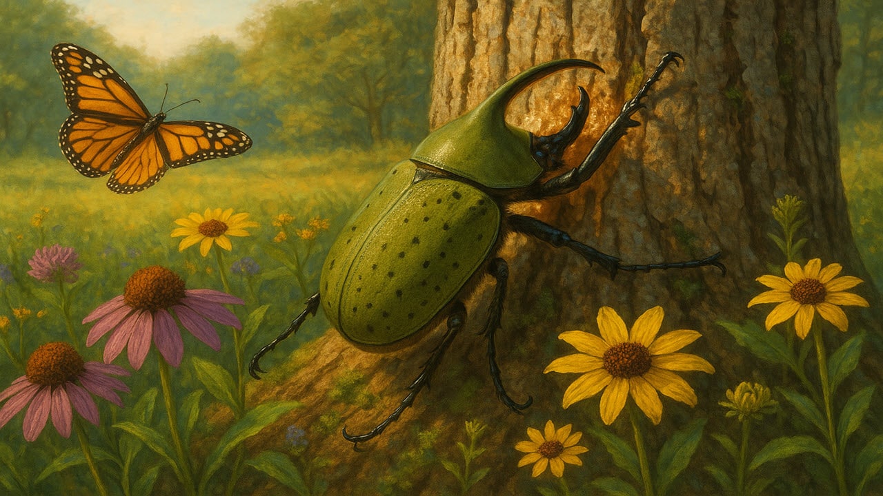
Spring has sprung in North Carolina. We have had our annual month-long experience of pollen coating everything, and now wildflowers are blooming, birds are singing, and the insects are waking up. I’ve already seen a few butterflies flitting about. Now, I know some of you are probably Lepidopteran fans, but me, I’m a Coleoptera person. For anyone unfamiliar with this lingo, Lepidoptera is the insect order containing butterflies and moths, while Coleoptera is the order containing beetles. I will probably discuss some of the more strange and unusual moths and butterflies in the future, but today, the time has come to talk about one of my favorite insect species, Dynastes tityus, otherwise known as the Eastern Hercules Beetle. 

Male Dynastes tityus, the Eastern Hercules Beetle. Photo by Arthur B. Evans

The Eastern Hercules Beetle has the honor of being the largest beetle in the Eastern United States, coming in at 1 ½ -2 ½ inches in length. The color varies and depends on the moisture content in the environment. In dry conditions, these beetles are yellow-green to olive green in color; in wetter conditions, they are varying degrees of brown, depending on how much water they have absorbed. When humidity is very high, water will replace air in the voids within their body, leading to an increase in water absorption. If that wasn’t weird and wonderful enough, the pattern of spots and blotches on their elytra, the hard, outer wing covers, are thought to be unique to each individual. Thus, different individual adult beetles can be differentiated from one another. For anyone familiar with North American box turtle species, this is similar to how their unique shell patterns are used to tell each turtle apart, which is helpful for population studies in their native habitats.  

Male Dynastes tityus peeling back the bark on an ash tree branch. Photo by John Bunch originally published in Banisteria.

Male Eastern Hercules Beetles have a large horn on their head that extends past their face, with three smaller horns on their pronotum, the dorsal body part sandwiched between the head and the elytra. Female Eastern Hercules Beetles lack horns and lay their eggs during the month of August, utilizing cavities at or near the base of several hardwood tree species, with large oaks tending to be the tree of choice. Once the larvae hatch, they feed on crumbling heartwood and rotten wood debris found in the cavity, and it can take as long as 2-3 years for them to pupate and turn into adult beetles. Adults feed on overripe and rotting fruit and tree sap, with ash tree species being a favorite. Indeed, a species observations note published in Entomological News way back in 1915 detailed 387 live specimens collected from a single ash tree! What an awesome sight that must have been to behold! The adult beetles grip a branch, peel the bark back, and feed on the resulting juices. Other insects may also get in on the fun and drink from the same scratch mark alongside an Eastern Hercules Beetle. Sadly, due to the invasive Emerald Ash Borer, a fellow beetle species, ash tree species all over the United States are dying. It is feared that the population of Eastern Hercules Beetle will dwindle, as there does not seem to be another group of tree species they favor as much for food as the ash group. There are treatments out there that have proven effective at treating and protecting ash trees from an Emerald Ash Borer infestation, so hopefully the ash tree population will begin to grow, and this big, beautiful bug, the Eastern Hercules Beetle, will be able to live its life in peace. The next time you stumble upon an ash tree in the summer, take a closer look. You might see some of these weird and wonderful beetles enjoying a cool drink on a hot day. 

Posted on — Leave a comment

Vanishing Reserves: How Global Warming Is Draining Earth’s Stored Water and Shifting Its Balance

The following blog post is a summary of the article, “Earth’s storage of water in soil, lakes and rivers is dwindling. And it’s especially bad for farming” by Melina Walling, published in the Associated Press on March 27, 2025. To read the original article, click here.

Hydrology professor Dongryeol Ryu of the University of Melbourne and his collaborator Ki-Weon Seo discovered a troubling trend while reviewing data during a train ride: Earth has lost a staggering amount of water stored on land. Initially dismissing the result as a model error, they spent a year validating their findings, which were ultimately published in Science. Their research reveals that global warming has drastically reduced the water stored in soil, lakes, rivers, and snow, with Earth losing over 2,000 gigatons of soil moisture in just two decades—more than double Greenland’s ice loss in a comparable period. This depletion has serious consequences, including increased frequency of extreme droughts, rising sea levels, and even a measurable shift in the Earth’s pole. The data, confirmed using three different sources, suggests that the land may have lost its ability to recover its former water storage capacity, despite dramatic rainfall events following droughts.

Whether this loss of elasticity can be reversed depends largely on human actions regarding climate change and water consumption. Rising temperatures increase plants’ water demands, while irrigation and other agricultural practices continue to deplete resources unsustainably. The continued emission of greenhouse gases without meaningful mitigation efforts further exacerbates the problem. According to scientists like Katharine Jacobs, long-term climatic shifts might eventually reverse the trend, but likely not within our lifetimes. The study also sheds light on a subtle wobble in Earth’s rotation, now linked to changes in land moisture. Hydrologist Luis Samaniego, who commented on the research, likened this wobble to an Earth-scale arrhythmia—an urgent signal we risk ignoring at our peril.

Posted on — Leave a comment

Building a Bridge Back to Nature: The Wallis Annenberg Wildlife Crossing Nears a Key Milestone

The following blog post is a summary of the article “World’s Largest Wildlife Crossing Reaches Critical Milestone. Now What?” by Jeanette Marantos, published in the Los Angeles Times on April 1, 2025. To read the original article, click here.

On Monday, the Wallis Annenberg Wildlife Crossing reached a significant milestone, symbolized by the arrival of soil atop the structure, though it still appeared unfinished to drivers on the 101 Freeway. This moment marked the near completion of Stage 1 of the project, which began nearly three years ago. Over the coming days, workers will spread 6,000 cubic yards of a specially formulated soil blend designed to replicate native conditions. This soil includes sand, silt, clay, compost, and mycorrhizal fungi sourced from the surrounding area to foster a thriving ecosystem. According to landscape architect Robert Rock, once seeding and planting are completed by this summer, attention will shift to Stage 2, which involves connecting the crossing to the hills on both sides and reconfiguring parts of Agoura Road to ensure seamless wildlife movement.

The project’s aim is to restore a natural corridor for animals like mountain lions that have long been endangered by habitat fragmentation due to roadways and urban development. Officials, scientists, and advocates, including Agoura Hills’ mayor pro tem Jeremy Wolf, gathered to celebrate the moment, emphasizing the importance of using human ingenuity to undo environmental damage. Before construction even began, experts collected native seeds and fungi from the local area, nurturing plants in a dedicated nursery and preparing the soil to support their growth. The care taken in soil composition, drainage, and design ensures a natural-looking and functional passageway for wildlife. Officials are hoping the crossing, once complete, will effectively camouflage itself into the hills, making it appear as though no freeway exists.

Efforts to mimic the natural landscape have included testing native seed interactions with fungi, selecting a cover crop to stimulate soil life, and using special materials like expanded clay shale for drainage. Thick sound-dampening walls were constructed to minimize traffic noise, while a rubber waterproof layer was laid beneath the soil. The soil itself was mixed and matured at a dedicated facility and adjusted to balance pH and chemical content. On Monday, soil was delivered to the top of the structure using a conveyor system and distributed with compact track loaders to avoid compaction. The final design includes variations in soil depth and the inclusion of sandstone and volcanic rocks to mirror the area’s natural topography.

In the coming weeks, cover crops such as golden yarrow and California poppy will be sown to stimulate fungal growth and prepare the ground for native plant installation. Later, a wide array of native shrubs and perennials — including various sages, milkweeds, buckwheats, and more — will be planted, all grown from locally sourced seeds. However, the project faces challenges from invasive species like black mustard, which are already appearing near the site and threaten to outcompete the native flora. Vigilant weeding will be necessary until the native plants take hold. Despite these challenges, the project’s detailed planning and innovative ecological design represent a major step forward in reconnecting fragmented habitats and preserving biodiversity.

Posted on — Leave a comment

North Carolina’s Weird and Wonderful: The Short-tailed Shrews

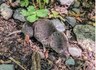
Blarina brevicauda, the Northern Short-tailed Shrew. Photograph courtesy of Jim Petranka and Mammals of North Carolina.

North Carolina is home to many weird and wonderful mammalian species, two of which have already been discussed in past issues of this blog. This month’s focus is on two small, unobtrusive species: the short-tailed shrews. North Carolina is home to both the Northern and the Southern species, and while there are physical traits that can distinguish them from each other, many individuals can only be identified by experts in shrew morphology. Both of these shrews are members of the Blarina genus, and both are relatively large, with tiny eyes, and reduced ears that are hidden by their thick, velvety fur. Their namesake comes from the fact that they have short tails that are around one-third the length of the head and body. Northern short-tailed shrews, Blarina brevicauda, tend to be larger on average than their Southern cousins, Blarina carolinensis; they also tend to be lighter in color. These two species overlap in the tidewater regions of our state, but elsewhere, the Northern type resides in the western mountains, while the Southern type lives in the piedmont and coastal plain. 

Short-tailed shrew skull.

These shrews prefer to tunnel under leaf litter in most terrestrial environments, including forests, salt marshes, and fields. They also utilize runways, or paths, on the surface, which are also frequented by mice, voles, and other shrew species. As a result, they are seldom seen unless a housecat catches and presents one to their humans. Short-tailed shrews communicate with each other through clicks, squeaks, and even echolocation! That’s a pretty weird and wonderful skill all on its own, but these two shrew species also communicate using a strong odor that they produce in glands near each hip. This odor becomes more potent during breeding season, when it is used to signal reproductive status, but throughout the year the odor communicates each individual shrew’s territorial boundaries. Short-tailed shrews are prolific breeders, with females giving birth to three to four litters every year from February through November. The nests are constructed of dried grasses and shredded leaves and are usually placed under tree stumps and fallen logs. Baby shrews are born pink and hairless, but they are weaned at about three weeks of age.  

Blarina brevicauda, Northern Short-tailed Shrew

Alright, now onto the really weird and wonderful trait about these little critters! Short-tailed shrews, and all shrew species, are insectivores, meaning they feed on insects and other small invertebrates. While they do not directly impact humans, and for the most part we do not directly impact them, shrews are beneficial because they provide insect control. Spiders, beetles, worms, grubs, snails, and even the occasional small vertebrate make up their diet. Short-tailed shrews, due to their high metabolism, must consume the equivalent of their body weight every day. That’s a lot of arthropods to catch and eat, but that process is made easier through the use of their venom. Yes, that’s right. Short-tailed shrews are venomous mammals! Unlike venomous snakes, which have hollow, hypodermic-like fangs to inject venom into their prey, short-tailed shrews’ have a groove on each of their bottom incisors. The venom flows down the groove and enters the prey through the bite wound; the shrews must bite and chew to really get the venom flowing into their prey. It has been hypothesized that a single shrew has enough venom in its tiny body to kill 200 mice at any given time. Usually, though, the short-tailed shrews either kill their prey, or paralyze it and stash it away for later. The next time you see something rustling under the leaf litter, remember that it could very well be one of these furry, tiny, venomous, weird and wonderful predators on the hunt for their next meal. 

Posted on — Leave a comment

2024 National Wetland Plant List Update: Evaluating Wetland Vegetation for Conservation and Policy

Illustration of a botanist studying plants in a wetland habitat.

The National Wetland Plant List (NWPL) is an essential tool for determining hydrophytic vegetation in wetlands under federal regulations, including the Clean Water Act and the Rivers and Harbors Act. Managed by the U.S. Army Corps of Engineers (USACE) in collaboration with the EPA, FWS, and NRCS, the NWPL is periodically updated to reflect new species records, taxonomic changes, and range extensions. For 2024, proposed changes to the wetland indicator status ratings of ten plant species across five regions are open for public comment until March 31, 2025. These ratings help classify plants into five categories—Obligate Wetland (OBL), Facultative Wetland (FACW), Facultative (FAC), Facultative Upland (FACU), and Upland (UPL)—based on their likelihood of occurring in wetlands. The NWPL serves as a critical resource for wetland restoration, conservation, and regulatory compliance.

The 2024 NWPL update process involved reviews by both Regional Panels (RPs) and the National Panel (NP) to assess proposed changes. One public request to change the status of Cicendia quadrangularis in the Arid West region was found to be unnecessary as the requested designation was already in place. However, changes were considered for two other species, Alnus incana and Amaranthus tuberculatus. Additionally, the Alaska RP requested evaluations for eight species with varying wetland indicator status ratings across subregions. Using advanced analytical methods such as multiple correspondence analysis and machine learning, the U.S. Army Engineer Research and Development Center collaborated with the Alaska RP to refine these ratings. The research findings informed proposed changes for several species while others remained unchanged due to insufficient data.

For specific species, revisions included downgrading Andromeda polifolia from OBL to FACW in certain subregions and adjusting Arctous rubra to match the state’s FAC designation. Salix arctica and Salix pulchra underwent reclassifications in specific subregions, while Viola palustris was proposed for a shift from FAC to FACW in select Major Land Resource Areas. The USACE encourages public participation in the NWPL update process by submitting data, observations, and supporting literature. Expert insights from regional botanists, field studies, and historical records help ensure accurate and scientifically supported classifications. Public input will be compiled and reviewed by the NP before finalizing the 2024 NWPL updates.

Posted on — Leave a comment

North Carolina’s Weird and Wonderful: Yellow-bellied Sapsucker

Illustration of a yellow-bellied sapsucker on a tree trunk in the NC Mountains

The Great Backyard Bird Count of 2025 has come to an end. Every year, over a period of a few days in February, people from all around the world bird-watch in their favorite spot and keep track of every species of bird and how many of each species they observe. Yes, I chose to use bird-watch instead of bird. Why? Because birdwatching is a broader term used to describe people who enjoy watching birds in any capacity, for any reason, and the terms birder and birding are usually used to refer to a person who is more serious in their study of birds and their natural histories. The Great Backyard Bird Count is meant to bring all bird lovers together, because the data you submit helps researchers around the globe better understand bird populations. In that spirit, this month’s edition of North Carolina’s Weird and Wonderful will focus on one of our more unusual birds: the yellow-bellied sapsucker. 

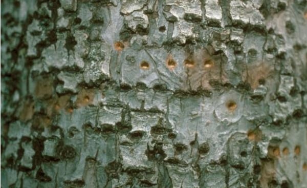
Photograph of the holes left behind by a yellow-bellied sapsucker courtesy of Tim Tigner, Virginia Department of Forestry, and Bugwood.org

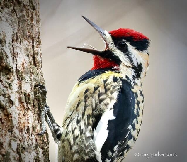
Let’s start with that name. Yellow-bellied sapsucker sounds like an insult tossed around during the Old West days of yore. I wasn’t around back then, so perhaps cattle rustlers and lawmen did call each other a yellow-bellied sapsucker while engaged in shoot-outs, but in this bird group the “sapsucker” refers to the fact that they drill holes in trees and drink the sap that leaks out. You can tell a tree has been visited by a member of the sapsucker genus if you see horizontal rows of ¼ inch holes. Sapsuckers use their brush-like tongue to lap or suck up the sap, though if a bug crosses their path while enjoying their drink, a yellow-bellied sapsucker will partake of the meatier morsel. In terms of the yellow-bellied portion of their name, this species does have a yellow belly, though it can appear white from a distance, and may be a brighter yellow in some individuals. They also have a bright yellow stripe that forms a V shape, with the ends of the V starting at the base of their neck and the point centered on their chest. 

Photograph of a yellow-bellied sapsucker, Sphyrapicus varius, courtesy of Mary Parker Sonis and the Carolina Bird Club.

Yellow-bellied sapsuckers are also unusual in that they tend to be the quietest of all the sapsuckers and woodpeckers, particularly in winter, which is when North Carolinians have the best chance of seeing them. Their breeding grounds are in the northeastern U.S., but they spend the late fall and winter season in the South, and some even migrate all the way to Central America. They have been found year-round in the high elevations of our state’s mountains, nesting in deciduous trees. Yellow-bellied sapsuckers favor trees that are afflicted with the tinder fungus. This fungal disease softens the heartwood of a tree but leaves the outer bark firm. Both the female and the male excavate the nest cavity, and the 5-7 eggs hatch about two weeks after being laid.  The young sapsuckers leave the nest after a month’s time, but their parents teach them how to drill holes and harvest sap for 10 days before their offspring begin their lives on their own. This species, with its brush-like tongue, distinctive coloring, and colorful name, is a shy bird by nature. While not fortunate enough, myself, to have seen one in person, I have observed the neat rows of holes they leave behind, and thinking about yellow-bellied sapsuckers always makes me smile. This weird and wonderful bird undoubtedly brings smiles to the faces of all who are fortunate enough to catch a glimpse.  

Posted on — Leave a comment

Toxic Waters: The 1,4-Dioxane Crisis in North Carolina

Illustrated image of a landfill full of plastic and waste materials next to a wastewater treatment plant, with wastewater and leachate dumped into the river.

North Carolina, like many other states, has had its fair share of environmental disasters. It is one thing when a disaster happens by accident; it is another thing entirely when it is allowed to happen on purpose. On January 22, 2025, the North Carolina Chamber of Commerce sent Senator Thom Tillis a letter urging him to use his role as a representative of North Carolinians to prevent the Environmental Protection Agency from intervening in the state’s current 1,4-dioxane dispute. The dispute involves the City of Asheboro, which discharges their wastewater into Hasketts Creek, a tributary of the Deep River in the Cape Fear River Basin. Now, discharging wastewater into river systems is nothing new: it has to go somewhere, and rivers are an easy way to get the water out of sight and out of mind. Over the past few decades, though, more and more chemical compounds found in wastewater have been discovered to be toxic to people. One might assume that, since the chemicals are in water that has already been used, it is not a problem if these chemicals are present, right? Well, that is not the case. You see, many of these chemicals, including 1,4-dioxane, remain in the water, soil, and air for years. 1,4-dioxane, once in water, never breaks down into less toxic compounds. 1,4-dioxane, and other toxic chemicals, that get discharged into the Cape Fear River Basin flow downstream…and right into the drinking water supply for thousands of North Carolinians. 

Of course, it is important to mention that wastewater treatment plants, including the City of Asheboro’s, are just that: they treat wastewater, and are typically not the source of any toxins present in the water. In fact, the only thing most wastewater treatment plants treat in the water before discharging it is coliform bacteria. So, where could the 1,4-dioxane come from? This compound is utilized in the manufacturing process for plastics, and there is only one company in the Asheboro area, Starpet, that makes plastic bottles. 1,4-dioxane is a common by-product of plastic manufacturing, but it is also utilized during the process. However, it is also suspected that some of the 1,4-dioxane is coming from landfill leachate. Landfill leachate is formed when rainwater filters through the waste in the landfill. As it flows through the waste, it draws out, or leaches, chemicals and constituents present in the waste materials. Now, solid waste landfills are supposed to have a liner that protects the groundwater and underlying soil from the leachate, in addition to leachate collection and removal systems, which collect the leachate for treatment and disposal. However, those systems do not always work, and leachate contains all sorts of toxins that are hazardous to people’s health.

Since rivers are a major — and sometimes only — source of drinking water for huge swaths of the population, as more toxins are identified and studied, more regulations are put in place so that the maximum amount found in discharged water is an acceptable level. That means the compound is at levels low enough that, according to the current research, it does not pose a direct health threat.  As more research is performed, acceptable levels are often adjusted. Currently, it is known that 1,4-dioxane has been linked to cancer in mice and rats exposed to it throughout their lives. In humans, short-term exposure causes eye and nose irritation; long-term exposure, while still being studied, is believed to be linked to liver and kidney cancer. Both the U.S. Department of Health and Human Services and the International Agency for Research on Cancer list 1,4-dioxane has having an increased potential in being a human carcinogen. According to the CDC’s Agency for Toxic Substances and Disease Registry, the level of 1,4-dioxane in water linked to a 1 in 10,000 chance of getting cancer is only 300 parts per billion in drinking water. The levels of this toxin found in the treated wastewater from Asheboro in January of 2025 varied from 2,200 parts per billion to 3,520 parts per billion, with the sample collected by the City of Asheboro Wastewater Treatment Facility receiving that higher score of 100 times over the CDC recommended limit. In comparison, the City of Greensboro, which also had a 1,4-dioxane problem in the recent past, ramped up their water sampling and started cracking down on industries that utilized the compound. In the first three four months of 2023, their highest concentration was hovering around 5 parts per billion.

If the North Carolina Chamber of Commerce gets its way, North Carolina will not have any regulations for 1,4-dioxane levels in wastewater discharge. This means private and public entities can release as much as they want without penalty, and in turn, everyone downstream from the discharge points will be exposed. This chemical harms everyone from all walks of life, business owners included. The Chamber, according to their website, works to “proactively drive positive change, ensuring that North Carolina is one of the best places in the world to do business.” Trying to run a business in an area where the drinking water contains unlimited quantities of 1,4-dioxane does not sound like one of the best places in the world to do business. Asking our senator to push for the de-regulation of a toxic chemical in wastewater discharge does all our business owners a disservice. Reach out to your elected officials and Senator Thom Tillis and let them know that you do not support the prevention of 1,4-dioxane regulations in North Carolina. 

Sources:

CDC Agency for Toxic Substances and Disease Registry. Public Health Statement for 1,4 Dioxane. https://wwwn.cdc.gov/TSP/PHS/PHS.aspx?phsid=953&toxid=199 

CDC Agency for Toxic Substances and Disease Registry. Toxicological Profile for 1,4-Dioxane. https://wwwn.cdc.gov/TSP/ToxProfiles/ToxProfiles.aspx?id=955&tid=199 

Castagno, Peter. “North Carolina Chamber asks Sen. Tillis to help prevent 1,4-dioxane regulation.” Port City Daily. 17 February 2025. https://portcitydaily.com/latest-news/2025/02/17/north-carolina-chamber-asks-sen-tillis-to-help-prevent-14-dioxane-regulation/ 

Jones, Sonny. “NCDEQ identifies elevated 1,4-Dioxane levels in Asheboro WWTP’s Wastewater.” Bladen Online. 8 February 2025. https://bladenonline.com/ncdeq-identifies-elevated-14-dioxane-levels-in-asheboro-wwtps-wastewater/ 

North Carolina Chamber of Commerce. “About Us.” North Carolina Chamber of Commerce. https://ncchamber.com/about/ 

Sorg, Lisa. “Investigations into spikes of 1,4-Dioxane in Asheboro, High Point still inconclusive.” NC Newsline. 21 July 2023. https://ncnewsline.com/2023/07/21/investigations-into-spikes-of-in-14-dioxane-in-asheboro-high-point-still-inconclusive/