Field Applications of Continuous Surface Connection: Practical Documentation for Wetland Jurisdiction
A practical 90-minute paid webinar for wetland scientists, consultants, project managers, and permitting professionals who need to apply Continuous Surface Connection guidance to real field conditions.
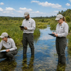
Continuous Surface Connection decisions are not made in the office alone. They depend on what is observed, photographed, mapped, and documented in the field. This webinar focuses on how to apply CSC concepts to real project sites where wetlands, streams, ditches, swales, berms, culverts, roads, and upland breaks can affect jurisdictional conclusions.
Rather than simply reviewing the guidance, this session focuses on field application. Participants will learn how to recognize direct abutment, document separation features, evaluate common problem areas, and organize observations into a clear recommended CSC finding.
This webinar is ideal for professionals who need to support Clean Water Act documentation, project records, ARDR packages, permit planning, client due diligence, or internal jurisdictional risk reviews.
Webinar Details
Date
Thursday, August 13, 2026
Time
1:00 PM EDT
Length
90 Minutes
Format
Live Online Webinar
Audience
Environmental Professionals
Bonus Field Materials Included
Downloadable tools to help document CSC conditions in the field
This webinar includes a downloadable Continuous Surface Connection Field Data Form designed to help organize field observations, document direct abutment, identify separation features, evaluate culverts, and support a recommended CSC finding.
Also included: a special CSC Data Collection Presentation that walks through each section of the field form and explains how to complete it during field review.
These materials are built for wetland scientists, consultants, field staff, and project managers preparing documentation for project records, permit planning, due diligence, or ARDR packages.
Bonus materials include: the CSC field form, a section-by-section form overview, and practical guidance for translating field observations into report-ready CSC language.
Why This Webinar Matters
Field teams are often asked to make fast decisions about wetland boundaries, surface water connections, and potential jurisdictional risk. Under the current CSC framework, those decisions need to be supported by clear field notes, photographs, maps, and observations.
A wetland may be close to a jurisdictional water, but closeness alone is not enough. The field record needs to show what the wetland physically touches, whether that feature is a jurisdictional water in its own right, and whether any upland, berm, road, swale, non-RPW, pipe, or discrete feature separates the wetland from the covered water.
This webinar focuses on how to document those observations in a way that supports better project decisions, clearer client communication, and stronger regulatory records.
What You Will Learn
- Field Application of CSC
Move beyond the guidance and learn how CSC concepts are applied on actual project sites.
- Direct Abutment
Evaluate whether the wetland directly abuts a jurisdictional water, rather than simply being nearby or draining toward it.
- Separation Features
Document uplands, berms, roads, fill, dikes, levees, swales, non-RPWs, pipes, and other features that may interrupt CSC.
- Culvert Evaluation
Understand when a culvert may be part of an RPW and when it may be only a discrete drainage feature.
- Field Notes and Photos
Improve how you document contact points, separation features, OHWM continuity, culverts, and uncertainty.
- Report-Ready Findings
Learn how to translate field observations into a clear recommended CSC finding for reports, project files, or ARDR support.
Who Should Attend
This webinar is designed for professionals who work with wetland delineation, waters evaluations, Clean Water Act permitting, environmental planning, due diligence, compliance, or jurisdictional risk.
Wetland Scientists
Environmental Consultants
Project Managers
Permitting Specialists
Field Staff
Agency Staff
Engineers and Planners
Due Diligence Teams
Group Enrollment Available
Training a team? Group enrollment options are available for firms, agencies, utilities, and project teams that want multiple staff members to attend the webinar together.
Group registration is a good option for organizations that want project managers, field staff, permitting specialists, and environmental team members to apply CSC documentation consistently across active projects.
Team Access
Enroll multiple staff members
Shared Field Practices
Build consistent CSC documentation
Easy Setup
We will collect your roster
After purchase, Swamp School will contact you to collect participant names and email addresses so your team can be registered for the webinar.
Need to Register More Than 10 People?
Custom group rates are available for larger teams, agencies, firms, and organizations that need to enroll more than 10 participants.
Contact Swamp School for a custom group registration option, and we will help coordinate enrollment for your full team.
Turn CSC Guidance into Better Field Documentation
Register now and learn how to document direct abutment, separation features, culverts, and field observations that support a recommended Continuous Surface Connection finding.