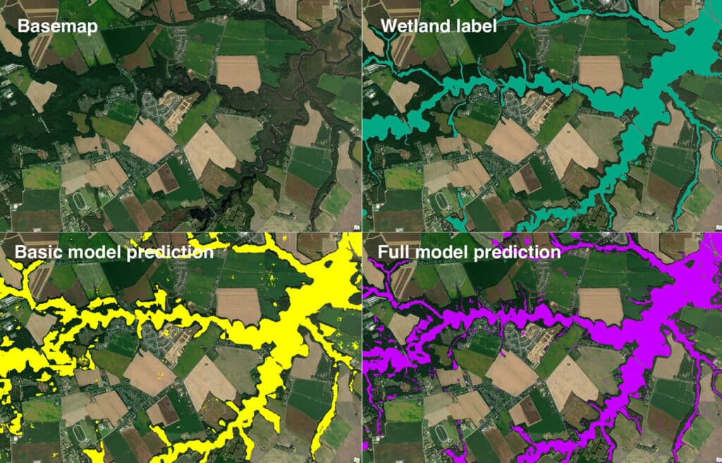
The use of remote sensing and geographic information systems (GIS) has become a crucial tool for land-use planning and conservation efforts. Wetlands prove to be one of the more difficult landscapes to map due to the limited availability of aerial imagery and their unique features. Wetlands do not share the same vegetative cover, hydroperiod, and topography across the board. These wetland features can interfere with the resolution of a remote sensor. This forces spatial analysts to develop workarounds for wetland mapping techniques.
New Mapping Tool
Researchers at the Chesapeake Conservancy have developed a new mapping tool that uses an artificial intelligence and machine learning algorithm to map wetlands. They tested the preliminary mapping tool at three different sites in Delaware, Minnesota, and New York. After comparing the sites, they determined that the tool effectively mapped the wetlands in the surrounding area with ~94% accuracy at 1m2 resolution.
Deep Learning Technology
Deep learning technology has become widely popular, especially with the advancement of smart devices. Tools and features that utilize deep learning algorithms include facial recognition, virtual assistants, and autonomous vehicles. This type of technology is also known for its enhancement of imagery, which is where the technology comes into play with remote sensing applications.
The research group at Chesapeake Conservancy trained a deep learning model known as a convolutional neural network (CNN). CNNs are commonly used to segment multispectral imagery. The neural network was programmed to obtain imagery from freely available sources like the Sentinel-2 satellite and the National Agricultural Imagery Program (NAIP).
As discussed earlier, wetland vegetation can hinder a remote sensor’s ability to accurately map wetlands. Forested wetlands are one of the hardest wetland ecosystems to map as the tree canopy obscures any visible water from airborne sensors. To combat this, the researchers at Chesapeake Conservancy incorporated the use of light detection and ranging (LiDAR) data in the mapping model to fill in any data gaps from aerial images. LiDAR is a remote sensing method that uses laser beams to create a three dimensional display of the Earth’s surface and features. Once LiDAR data was incorporated into the model, the tool improved it’s mapping accuracy by 2%.
The research team used the NWI as reference data for their mapping tool, but quickly found discrepancies with what had been mapped on the NWI versus the current conditions in the field. With these discrepancies in mind, the research team presumes that their mapping tool could be more accurate than 94%.
Intended Use and Application
The hope for this tool is that it will develop new approaches to enhance the U.S. Fish and Wildlife’s National Wetland Inventory (NWI), and promote accurate wetland location predictions. The Chesapeake Conservancy is expanding the mapping model to other states to train the model on different geographies. It will be interesting to see how this model improves overtime and whether its usage will be released to the public for wetland identification.
Sources
Chesapeake Conservancy. (2023). Artificial intelligence deep learning model for mapping wetlands yields 94% accuracy. Retrieved from https://phys.org/news/2023-01-artificial-intelligence-deep-wetlands-yields.html.
Gallant, A.L. (2015). The challenges of remote monitoring of wetlands. Remote Sensing, 7(8), 10938-10950. Retrieved from https://doi.org/10.3390/rs70810938.
Mainali, K., Evans, M., Saavedra, D., Mills, E., Madsen, B., & Minnemeyer, S. (2023). Convolutional neural network for high-resolution wetland mapping with open data: Variable selection and the challenges of a generalizable model.
Science of The Total Environment, 861. Retrieved from https://doi.org/10.1016/j.scitotenv.2022.160622.
U.S. Fish and Wildlife Service. (n.d.). Wetlands data limitations, exclusions and precautions. Retrieved from https://www.fws.gov/node/264582
