Where have all the wetlands gone?

Peter, Paul, and Mary could very easily have been talking about our country’s wetlands instead of flowers in their 1962 hit, “Where Have All the Flowers Gone.”  When wetlands were first forming, thousands of years ago as the ice age ended, the United States was 90% covered with wetlands. Today, coastal and inland wetlands cover only about 5.5% of the United States. 

The Ramsar Convention estimates that nearly 90 percent of all the world’s wetlands have disappeared since the 1700s, and those that remain are at risk of disappearing three times faster than forests. In 1989, Congress directed the Department of the Interior to compare the estimated total number of wetland acres in the 1780s and in the 1980s in the areas that now comprise each state. The report, released by the U.S. Fish and Wildlife Service (FWS), was designed as a one-time effort to document historical wetland losses from colonial times through the 1980s. This report is updated every 10 years providing new information based on a statistical analysis of wetlands changes from the 1970s through the 1980s.

As with historical estimates, data on present wetland acreage must be interpreted with caution. For some states, wetlands have been mapped for the entire state by the FWS National Wetlands Inventory. However, for those states where wetlands are not completely mapped or where acreage summaries are not yet compiled, an accurate accounting of wetland acreage is not always available, so the best national or regional data available to determine statewide totals was used. Additionally, the status of wetlands in the United States is constantly changing. It is estimated that, on average , over 60 acres of wetlands have been lost every hour in the lower 48 states during this 200-year time span.

Considerable changes in wetland distribution and abundance have taken place since the 1780s. In the conterminous United States, only an estimated 104 million acres of wetlands remained through the 1980s, representing a 53-percent loss from the original acreage total. If Alaska and Hawaii are counted, an estimated 274 million wetland acres remain.

By all estimates, the national decline in wetlands from the 1780s to the 1980s is dramatic. Losses in particular regions of the country such as the mid-western farm belt states of Illinois, Indiana, Iowa, Michigan, Minnesota, Ohio, and Wisconsin are even more startling. Alaska stands alone as the only state in which wetland resources have not been substantially reduced. 

Incomplete baseline data on the wetlands in the United States prevents an accurate appraisal of the “health” of these remaining resources. However, population growth and distribution and agricultural development greatly affect land-use patterns that impact wetlands . Despite increased efforts to conserve wetlands through state and federal legislation, hundreds of thousands of acres have been drained annually. Wetland acreage has diminished to the point where environmental and even socio-economic benefits are now seriously threatened.

The years from the mid-1950s to the mid-1970s were a time of major wetland loss, but since then the rate of loss has decreased. How will climate change and global warming affect wetlands as our country and the rest of the world continue to experience unprecedented heat waves. The fact that the definition of a wetland changes often makes these numbers even harder to predict. The total amount of wetlands can change in an instant depending on the wording of a government document. 

Various factors have contributed to the decline in the loss rate of wetlands including implementation and enforcement of wetland protection measures and elimination of some incentives for wetland drainage. Public education and outreach about the value and functions of wetlands, private land initiatives, coastal monitoring and protection programs, and wetland restoration and creation actions have also helped reduce overall wetland losses.  Hopefully, this will be enough.

References:

https://share.america.gov/us-protects-wetlands/
https://www.archives.gov/

https://georgewbush-whitehouse.archives.gov › 2004/04

The Wetlands Initiative; Founded, 1994,  http://www.wetlands-initiative.org/


How the U.S. Protects the Environment, From Nixon to Trump By Robinson Meyer

Dahl, T.E. and C.E. Johnson . 1991. Status and Trends of Wetlands in the

Conterminous United States, Mid-1780’s to Mid-1980’s. U.S. Department of

the Interior, Fish and Wildlife Service, Washington, D.C.

August 2023 Definition of Waters of the United States

On August 29, 2023 the US EPA and the US Army Corps of Engineers released a pre-publication version of the conforming amendment to the 2023 definition a Waters of the US. I cannot recall ever having seen a “conforming amendment” in all my years working with this issue. In fact, I am not sure it has ever been done before in any circumstance. I expect the next round of challenges to this rule will focus on this.

The final version of this rule is the weakest version of the Waters of the US we have ever had. The amount of wetlands no longer covered by Clean Water Act protections is the lowest it has ever been including the Navigable Waters Protection Rule era. It is also important to note that the Supreme Court Decision that prompted this new rule was a unanimous (9-0) one. All nine justices were in agreement despite popular media decrying it was the right side of the bench that dominated the Decision.

This is a final rule and becomes effective on the date it is published in the Federal Register. There is no public comment period. I am still unclear as to why the agencies are in such a hurry to not regulate wetlands.

Much of the new rule discusses why it is proper to issue a conforming amendment without a public comment period. The rule itself is fairly brief, in that it provides the edits to the existing Biden rule. The rule itself does not merge the two rules together into a single document. They leave that up to you. However, we have done this for you and the total new conforming rule follows. We will also be hosting a webinar on this new rule on September 28, 2023. Hope to see you there!

Title 33 —Navigation and Navigable Waters

Chapter II —Corps of Engineers, Department of the Army, Department of Defense

Part 328 —Definition of Waters of the United States

Authority: 33 U.S.C. 1251 et seq.

Source: 51 FR 41250, Nov. 13, 1986, unless otherwise noted.

§ 328.3 Definitions.

For the purpose of this regulation these terms are defined as follows:

(a) Waters of the United States means:

(1) Waters which are:

(i)  Currently used, or were used in the past, or may be susceptible to use in interstate or foreign commerce, including all waters which are subject to the ebb and flow of the tide;

(ii) The territorial seas; or

(iii) Interstate waters,

(2)  Impoundments of waters otherwise defined as waters of the United States under this definition, other than impoundments of waters identified under paragraph (a)(5) of this section;

(3) Tributaries of waters identified in paragraph (a)(1) or (2) of this section that are relatively permanent, standing or continuously flowing bodies of water;

(4) Wetlands adjacent to the following waters:

(i) Waters identified in paragraph (a)(1) of this section; or

(ii) Relatively permanent, standing or continuously flowing bodies of water identified in paragraph (a)(2) or (a)(3) of this section and with a continuous surface connection to those waters.

(5) Intrastate lakes and ponds not identified in paragraphs (a)(1) through (4) of this section that are relatively permanent, standing or continuously flowing bodies of water with a continuous surface connection to the waters identified in paragraph (a)(1) or (a)(3) of this section.

(b)  The following are not “waters of the United States” even where they otherwise meet the terms of paragraphs (a)(2) through (5) of this section:

(1)  Waste treatment systems, including treatment ponds or lagoons, designed to meet the requirements of the Clean Water Act;

(2)  Prior converted cropland designated by the Secretary of Agriculture. The exclusion would cease upon a change of use, which means that the area is no longer available for the production of agricultural commodities. Notwithstanding the determination of an area’s status as prior converted cropland by any other Federal agency, for the purposes of the Clean Water Act, the final authority regarding Clean Water Act jurisdiction remains with EPA;

(3)  Ditches (including roadside ditches) excavated wholly in and draining only dry land and that do not carry a relatively permanent flow of water;

(4) Artificially irrigated areas that would revert to dry land if the irrigation ceased;

(5)  Artificial lakes or ponds created by excavating or diking dry land to collect and retain water and which are used exclusively for such purposes as stock watering, irrigation, settling basins, or rice growing;

(6)  Artificial reflecting or swimming pools or other small ornamental bodies of water created by excavating or diking dry land to retain water for primarily aesthetic reasons;

(7)  Waterfilled depressions created in dry land incidental to construction activity and pits excavated in dry land for the purpose of obtaining fill, sand, or gravel unless and until the construction or excavation operation is abandoned and the resulting body of water meets the definition of waters of the United States; and

(8)  Swales and erosional features (e.g., gullies, small washes) characterized by low volume, infrequent, or short duration flow.

(c) In this section, the following definitions apply:

(1)  Wetlands means those areas that are inundated or saturated by surface or ground water at a frequency and duration sufficient to support, and that under normal circumstances do support, a prevalence of vegetation typically adapted for life in saturated soil conditions. Wetlands generally include swamps, marshes, bogs, and similar areas.

(2)  Adjacent means having a continuous surface connection.

(3)  High tide line means the line of intersection of the land with the water’s surface at the maximum height reached by a rising tide. The high tide line may be determined, in the absence of actual data, by a line of oil or scum along shore objects, a more or less continuous deposit of fine shell or debris on the foreshore or berm, other physical markings or characteristics, vegetation lines, tidal gages, or other suitable means that delineate the general height reached by a rising tide. The line encompasses spring high tides and other high tides that occur with periodic frequency but does not include storm surges in which there is a departure from the normal or predicted reach of the tide due to the piling up of water against a coast by strong winds such as those accompanying a hurricane or other intense storm.

(4)  Ordinary high water mark means that line on the shore established by the fluctuations of water and indicated by physical characteristics such as clear, natural line impressed on the bank, shelving, changes in the character of soil, destruction of terrestrial vegetation, the presence of litter and debris, or other appropriate means that consider the characteristics of the surrounding areas.

(5)  Tidal waters means those waters that rise and fall in a predictable and measurable rhythm or cycle due to the gravitational pulls of the moon and sun. Tidal waters end where the rise and fall of the water surface can no longer be practically measured in a predictable rhythm due to masking by hydrologic, wind, or other effects.

NC Court rules that trawling doesn’t violate Clean Water Act

Reprinted from Coastal Review

Commercial shrimpers can continue to harvest by trawler in the Pamlico Sound without a Clean Water Act permit, and the state will continue to manage its fisheries.

The U.S. Court of Appeals upheld a district court’s Sept. 17, 2021, decision that trawling in the North Carolina estuary does not violate the Clean Water Act, as alleged in a lawsuit that the North Carolina Coastal Fisheries Reform Group filed in August 2020 against a half-dozen commercial shrimping businesses. 

The reform group argued that bycatch being thrown back into the water is a pollutant and disturbing sediment with trawl nets is dredging, either of which, the group contended, would require commercial shrimpers to obtain a Clean Water Act permit. The three-judge panel rejected the argument.

The district court dismissed the suit in 2021 because the Clean Water Act does not regulate bycatch — the state does — and that disturbing sediment with trawl nets does not violate the act.

The Clean Water Act establishes “the basic structure for regulating discharges of pollutants into the waters of the United States and regulating quality standards for surface waters,” the EPA explains.

The Court’s Decision

“We affirm the district court’s decision that Fisheries Reform Group fails to plausibly allege that shrimp trawlers are violating the Clean Water Act by either (1) throwing their bycatch back into Pamlico Sound, or (2) disturbing sediment on the Sound’s floor with their trawl nets, thereby causing it to resettle,” Judge Julius Richardson wrote in the panel’s unanimous opinion decided Aug. 7

Congress leaves fisheries management, including bycatch, to the state or the National Marine Fisheries Service for waters 3 miles offshore, not the Environmental Protection Agency, which enforces the Clean Water Act, he notes.

The fisheries reform group, a Wilmington-based nonprofit established in 2020, “to change how the State of North Carolina manages our public trust marine resources,” filed the lawsuit against Capt. Gaston LLC, Esther Joy Inc., Hobo Seafood Inc., Lady Samaira Inc., Trawler Capt. Alfred Inc., Trawler Christina Ann Inc., and Trawlers Garland and Jeff Inc. 

The reform group’s legal counsel, Jim Conner, told Coastal Review in an email that “the massive corporate-owned shrimp dredges are tearing up Pamlico Sound” and destroying fisheries across the entire region. 

“Their dredges tear up the bottom and their nets capture and kill four pounds of finfish and other life for every one pound of shrimp, killing billions of fish every year that are simply dumped back into the water as pollutants,” he said. “The Court missed an opportunity to apply the clear and unambiguous wording of the Clean Water Act to protect North Carolina estuaries and fisheries.”

“A Win for All Fishermen”

North Carolina Fisheries Association Executive Director Glenn Skinner said in a press release last week that while the organization was not in the lawsuit, members paid attention because the decision would have had “tremendous repercussions” for shrimpers, the industry, and commercial and recreational fishermen nationwide.

“This is a huge win for all fishermen, commercial and recreational. If the courts had decided with Mr. Joseph Albea and the Coastal Fisheries Reform Group, the results would have been devastating for both sectors,” Skinner said in a statement.

Judge Richardson explains in his published opinion that the major-questions doctrine was the deciding factor in this case. The major-questions doctrine is a legal background rule for when the question at hand has “significant political and economic consequences.” In this case, “whether returning bycatch qualifies as a ‘discharge’ of a ‘pollutant’ under the Act is a major question.”

Richardson explains that this is different from other major-questions cases because with those, it’s usually an agency asserting more power than is authorized by Congress. Here, it’s a citizen suit between private parties, and the authority that the Fisheries Reform Group seeks for the EPA would have significant political and economic consequences.

“Interpreting the Act to require the EPA to regulate bycatch would give it power over ‘a significant portion of the American economy,’” he writes. 

“If we sided with Fisheries, the immediate consequence would be to simply ban the shrimpers from throwing their bycatch into Pamlico Sound. That might sound like a small effect; yet the consequences would be vast,” Richardson writes. “For, if we adopted Fisheries’ reading of the statute and held that bycatch falls within the Act’s definition of pollutant, then that same reading would force the EPA to regulate not just all bycatch, but virtually all fishing, through the Act’s permitting scheme. The economic and separation-of-powers stakes of our ruling thus mirror those at play in other major-questions cases.”

The North Carolina Fisheries Reform Group first petitioned the North Carolina General Assembly in January 2020 by letter, expressing its concerns with how the state manages fisheries. Shortly after, group members retained Conner as counsel. 

On May 13, 2020, the group sent to the Division of Marine Fisheries, North Carolina Department of Environmental Quality, and the commercial fishing businesses a 60-day notice of intent to file a citizen suit under the Clean Water Act’s “prohibition against discharging pollutants into navigable waters and provisions regarding dredging activities.” 

The reform group filed Aug. 4, 2020, the lawsuit in the U.S. District Court for the Eastern District of North Carolina against the commercial shrimpers, NCDEQ and Division of Marine Fisheries. The group voluntarily dismissed its claim against the state, but pursued the lawsuit against the businesses. 

In an interview last week, Skinner with the North Carolina Fisheries Association, a nonprofit commercial fishing trade group, said he had spoken to a few of the defendants, and they were relieved. 

“The big problem is, and I don’t think most people look at it this way, Mr. Albea and his group didn’t sue the EPA. They didn’t sue a state or federal agency. They sued individuals who were operating legally. You’re allowed to shrimp in Pamlico Sound,” Skinner said. This lawsuit “cost those people hundreds of thousands of dollars for nothing.”

Skinner said that through the Shrimp Fisheries Management Plan, “And most people aren’t aware of this, we have to work to conserve habitat.” 

Shrimp Trawling in NC

North Carolina has a little over 2 million acres of estuarine waters and a million of that is permanently closed to shrimp trawling, either because it’s a nursery area for juvenile wildlife or to protect seagrass or habitat. “We’ve closed half of our estuary already permanently,” he said.

The North Carolina Marine Fisheries Commission, the rulemaking body for estuarine and marine fisheries management, has had its Shrimp Fishery Management Plan in place since 2006. The Division of Marine Fisheries implements and enforces the measures approved by the commission. 

Depending on the type of trawl used in the Pamlico Sound, average vessel length ranged from 22 to 53 feet in 2010-2011, according to the plan’s Amendment 1. The Pamlico Sound has accounted for about 56% of total commercial shrimp landings in North Carolina since 1994, the Amendment 2 published in 2022 states.

Division Biologist Supervisor Chris Stewart, in an email response to questions about how the Shrimp Fishery Management Plan works, explained that the 2006 plan implemented several area closures and a 90-foot head rope limit in the waters that surround the Pamlico Sound. 

The head rope is the top line of the net, or trawl webbing, that is measured from the outermost mesh knot at one end of the trawl following along the line to the outermost mesh knot at the opposite end, according to the division. 

Amendment 1 established a maximum combined head rope length of 220 feet in the Pamlico Sound and convened an industry workgroup to test gear combinations that achieved at least a 40% reduction in finfish bycatch, Stewart explained.  

Under the May 2018 revision to Amendment 1 and continued through Amendment 2, fishers are required to use one of four gear combinations that achieved at least 40% finfish bycatch in all shrimp trawls, except skimmer trawls, in the Pamlico Sound and portions of the Pamlico, Bay, and Neuse rivers. 

“It is important to note that these reductions in bycatch are in addition to the 30% reduction in finfish bycatch mandated by the federal bycatch reduction device (BRD) certification process and achieve nearly twice the federal requirements for reducing bycatch,” he said. “With the adoption of Amendment 2, shrimp trawling was prohibited in crab spawning sanctuaries designated at Oregon, Hatteras, Ocracoke, and Drum inlets.”

Stewart said that that the division doesn’t have bycatch numbers. 

“While the portion of bycatch that is sold (incidental catch) is recorded on trip tickets, the portion of bycatch discarded at sea is highly variable and characterization studies completed by the division are spatially and temporally limited. Thus, more data is needed to quantify the total magnitude of bycatch in the shrimp trawl fishery,” Stewart said. “Currently, the Division is investigating the feasibility of developing a long-term shrimp trawl observer program to better monitor and quantify annual shrimp bycatch.”

Source

Allen, J. (2023). Court upholds that trawling doesn’t violate Clean Water Act. Coastal Review. Retrieved from https://coastalreview.org/2023/08/court-upholds-that-trawling-doesnt-violate-clean-water-act/

2023 Waterfowl Status Report

Reprinted from Ducks Unlimited

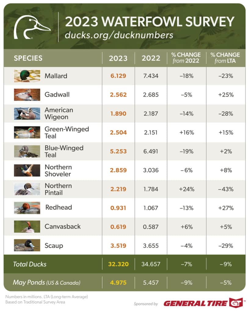
On August 18th, The U.S. Fish and Wildlife Service released its report on 2023 Waterfowl Population Status based on surveys conducted in May and early June by FWS, Canadian Wildlife Service and other partners.

Total populations were estimated at 32.3 million breeding ducks in the traditional survey area, a 7% drop from 2022’s estimate of 34.7 million and 9% below the long-term average (since 1955).

Also included in the report are breeding population estimates for 6 common duck species groups from the Eastern Survey Area, covering eastern Canada and the northeastern states from Virginia to Maine, as well as status updates on populations of geese and swans.

DU Chief Scientist Dr. Steve Adair said the overall numbers reflect a complex relationship between waterfowl, weather, and habitat availability.

“These results are somewhat disappointing, as we had hoped for better production from the prairies following improved moisture conditions in spring of 2022.. Last year’s nesting season was delayed with April snowstorms and May rains, which likely impacted overall production. In the past, we have seen population growth lag moisture conditions as small, shallow wetlands recover from the lingering impacts of severe drought.”

Key Takeaways

  • Populations of most species remain healthy and near the long-term averages, which should produce a respectable flight for waterfowl hunters and waterfowl enthusiasts to enjoy this fall and winter.
  • Total pond numbers in the U.S. and Canada were estimated at 5 million, which was 9% lower than the 2022 estimate of 5.5 million and slightly below the long-term average of 5.2 million.
  • Mallard and American wigeon populations declined. Estimates for mallards were down 18% from 2022 and 23% from their long-term average. American wigeon were down 14% from 2022 and 28% from their long-term average. These declines are a concern for DU scientists and amplify the need for sustained investments in conservation, monitoring, and targeted science.
  • Pintails provided a noteworthy bright spot. Population estimates increased 24% over the record low from last year. Although the survey showed that overall duck populations remain healthy, it also told a story of continuing drought in the western Canadian prairie provinces, which will limit production for ducks that traditionally settle in those landscapes.
  • Subsequent surveys will paint a more complete picture of how well duck populations are recovering from the severe drought of 2020–2021.
  • Highly pathogenic avian influenza – Based on reports from waterfowl managers and wildlife disease experts of partner agencies, DU scientists don’t expect a significant impact on duck populations from the HPAI outbreak of 2022.

“Lower than expected numbers in this year’s survey reinforce the need for wetlands conservation as habitat continues to be lost across the continent,” said Ducks Unlimited CEO Adam Putnam. “For over 86 years, DU has focused on North American wetlands and grasslands that sustain healthy waterfowl populations, and support clean water for people, too. As much as we have accomplished, these data confirm we have more work to do.”

What’s Next

“We remain concerned about the continuing loss and degradation of habitat in the prairies and long-term impacts on carrying capacity and productivity,” Adair said.

Regardless of pond counts and precipitation, waterfowl need productive habitat across their lifecycle to breed, migrate, and winter successfully. Ducks Unlimited, in partnership with the U.S. Fish and Wildlife Service and numerous other governmental, nonprofit and corporate partners, recently surpassed 16 million acres of protected or restored waterfowl habitat.

Ducks Unlimited continues to establish innovative research projects to better understand the needs of waterfowl and better guide conservation efforts. And landowners are a crucial component of healthy landscapes. Farmers and private landowners – with help from voluntary incentive-based programs in the U.S. Farm Bill – can help conservation organizations produce healthier wetlands and grasslands.

The united effort to protect wetlands has paid off over many decades: a recent State of the Birds report shows waterfowl and other wetland-dependent birds are the only species to increase in numbers since the 1970s, primarily because of conservation efforts.

To invest in tomorrow’s wetlands and waterfowl populations, Ducks Unlimited, Ducks Unlimited Canada, Ducks Unlimited de Mexico, and Wetlands America Trust have joined forces to launch Conservation For a Continent, a historic $3 billion capital campaign. Conservation For a Continent is one of the largest North American fundraising efforts to support habitat protection and restoration. Learn more about this effort.

View the full 2023 Waterfowl Population Status report from the U.S. Fish and Wildlife Service.

Source

Ducks Unlimited. (2023). 2023 Duck Population Numbers. Ducks Unlimited. Retrieved from https://www.ducks.org/conservation/waterfowl-surveys/2023-duck-numbers

The New USACOE Civil Monetary Penalty Inflation Adjustment Rule

On 3 August 2023, the U.S. Army Corps of Engineers (Corps) issued a final rule to adjust its civil monetary penalties (CMP) under the Rivers and Harbors Appropriation Act of 1922 (RHA), the Clean Water Act (CWA), and the National Fishing Enhancement Act (NFEA) to account for inflation.  With this new rule, the new statutory maximum penalty levels listed in on Table 1 below and will apply to all statutory civil penalties assessed on or after the effective date of this rule. This represents a 7.745% increase over the 2022 rate.

In addition, violations are considered Class I administrative penalty orders under Section 309(g) of the Clean Water Act, judicially-imposed civil penalties under Section 404(s) of the Clean Water Act, and Section 205 of the National Fishing Enhancement Act. Under Section 309(g)(2)(A) of the Clean Water Act.  Class I civil penalties may not exceed $25,848 per violation, except that the maximum amount of any Class I civil penalty shall not exceed $64,619. Under Section 404(s)(4) of the Clean Water Act, judicially-imposed civil penalties may not exceed $64,619 per day for each violation. Under Section 205(e) of the National Fishing Enhancement Act, penalties for violations of permits issued in accordance with that Act shall not exceed $28,304 for each violation.

The statutory civil monetary penalty amounts are for violations that occurred after November 2, 2015, and are assessed on or after August 3, 2023.

Table 1

CitationCivil Monetary Penalty (CMP) amount established by law2022 CMP amount in effect prior to this rulemaking2022
Inflation
adjustment
multiplier
CMP Amount as of August 3, 2023
Rivers and Harbors Act of 1922 (33 U.S.C. 555)$2,500 per violation$6,270 per violation1.07745$6,756 per violation.
CWA, 33 U.S.C. 1319(g)(2)(A)$10,000 per violation, with a maximum of $25,000$23,990 per violation, with a maximum of $59,9741.07745$25,848 per violation, with a maximum of $64,619.
CWA, 33 U.S.C. 1344(s)(4)Maximum of $25,000 per day for each violationMaximum of $59,974 per day for each violation1.07745Maximum of $64,619 per day for each violation.
National Fishing Enhancement Act, 33 U.S.C. 2104(e)Maximum of $10,000 per violationMaximum of $26,269 per violation1.07745Maximum of $28,304 per violation.

Wayne County wetland continues to suffer

Reprinted from NC Health News by Will Atwater

A year after a collapsed digester caused nearly a million gallons of hog waste to escape, investigators found high levels of fecal bacteria in a nearby waterway.

Last August, during a routine surveillance flyover, Samantha Krop spotted something odd at White Oak Farm, a Wayne County biogas and industrial hog farm operation.

“I noticed that the lagoon, which is a covered lagoon, meant to be producing biogas through the anaerobic digestion process, was flattened, and it just looked different,” said Krop, the Sound Rivers Neuse Riverkeeper. 

Curious about what she’d seen during the flight, Krop decided to dig through the N.C. Department of Environmental Quality’s records for possible answers.

“We found sort of a treasure trove of documents outlining a major spill that had happened there over Memorial Day weekend,” Krop said.

In May 2022, the owners of White Oak Farm reported to the NCDEQ that nearly a million gallons of hog feces, decomposing hog carcasses and food waste seeped from a failed hog waste “digester” and spread out over surrounding fields. Of the total waste amount, 10,745 gallons also entered the Nahunta Swamp, a “water of the state,” according to an NCDEQ release issued in December of last year.

Accounts differ regarding how much waste flowed from the site into nearby wetlands. In a Sept. 6, 2022 article, the News and Observer reported that a minimum of “37,000 gallons” of hog waste, roughly three times the amount reported by NCDEQ, had reached nearby wetlands.

By the close of 2022, NCDEQ’s Division of Water Resources issued a $34,520 fine to the operators of White Oak Farm “related to a May 2022 waste discharge at an animal operations facility in Wayne County,” according to the agency.

A notice of more infractions

Earlier this month, roughly a year after Krop’s surveillance flyover, NCDEQ sent a letter to B&B Partnership, the owners of White Oak Farm, informing them that the Nahunta wetland is still being affected by runoff from the farm.

Specifically, water sampling tests performed in March and April revealed “high levels of fecal coliform and nutrients in an unnamed tributary to Nahunta Swamp west of the digester at your facility,” according to the letter.

Also spelled out in the letter is that the amount of fecal coliform — the type of bacteria present in feces that can cause illness in humans and animals — far exceeds the allowed standards during testing that extended over at least a month’s time.

The second violation identified in the letter concerns the ongoing point-source discharge into nearby Nahunta Swamp. White Oak Farm is required to “eliminate the discharge of animal waste to surface waters and groundwater through direct discharge, seepage, or runoff,” according to the letter. To achieve this goal, “all earthen structures must include a synthetic liner often made of reinforced polypropylene to prevent seepage.”

Responding to a query from NC Health News about a liner requirement for lagoons, a spokesperson for the NCDEQ Division of Waste Resources offered the following response:

Under White Oak Farms’ individual permit, the lagoon is clay-lined and does not have a synthetic liner. However, additional groundwater monitoring, with data submitted to the state, was required by the permit to demonstrate conformity with groundwater provisions. Under state law the farm was allowed to expand animal headcount by installing an ‘innovative animal waste system’ intended to prevent groundwater contamination. The recent [notice of violations] sent to the farm, based on surface water monitoring data collected by the Division, noted that the installed system was not functioning as intended or allowed under its permit.

More digesters, more problems?

As word of the bio-digester collapse that led to environmental contamination became public, Krop and other environmentalists expressed disappointment with how NCDEQ handled the situation.

“This facility has a clear history of illegally discharging waste, and DEQ knew it,” Krop said in a release. “They failed to take meaningful action to prevent a major pollution event from happening and failed to adequately notify the public.”

A year later, Krop is glad that NCDEQ has continued its investigation of White Oak Farm.

“It is very encouraging to see that they opened up a pretty thorough investigation and are following up on this with a notice of violation,” she said. “I would say that’s what we would expect as a baseline response, given the severity of this ongoing pollution and the long history of violations at this facility.”

On a scale of one to 10, contract hog farmer and environmental activist Tom Butler said he’d give NCDEQ a two for handling the White Oak Farm situation. He said external pressures limit the agency’s ability to do its job. Butler uses a digester to convert hog waste into energy to power his farm. 

However, Butler is sensitive to his operation’s impacts on neighbors and the environment. He frequently speaks about how, he says, the industry and state government value profits above all else.

Cape Fear Riverkeeper Kemp Burdette is concerned that more industrial hog operations, and other entities installing or planning to install digesters to capture and convert methane to natural gas to sell on the market, will lead to more problems down the road.

“When you cover up a digester and prevent it from off-gassing ammonia, for instance, you’re concentrating the nitrogen that’s in the ammonia molecule in the digester,” he said. “So you’re likely to create more problems as water quality impacts go.”

Sources

Atwater, W. (2023). Wayne County wetland continues to suffer: Farm with massive hog waste spill nets new violations amid bacteria concerns. NC Health News. Retrieved from: https://www.northcarolinahealthnews.org/2023/07/28/wayne-county/

North Carolina Health News is an independent, non-partisan, not-for-profit, statewide news organization dedicated to covering all things health care in North Carolina. Visit NCHN at northcarolinahealthnews.org.

The Fiery Origin of Carolina Bays

Reprinted from Coastal Review

They are neither confined to the Carolinas, nor are they bays. That their name is misleading is in many ways very appropriate for the enigmatic formations known as Carolina bays.

But it isn’t what they are that holds the mystery; rather it is how did they get here?

Found in the coastal plains along the Atlantic shoreline, Carolina bays are shallow wetland depressions that are fed by rain or groundwater. They range in size from less than an acre to thousands of acres.  Most of the 500,000 or so Carolina Bays are in the Carolinas and Georgia, with the highest concentration found in Bladen County in North Carolina’s southeast coastal plain.

The term “bay” is a nod to the various species of bay trees and shrubs commonly found growing alongside most Carolina bays, but they are also unique reservoirs of many species of carnivorous plants, salamanders, frogs, turtles, birds and mammals.

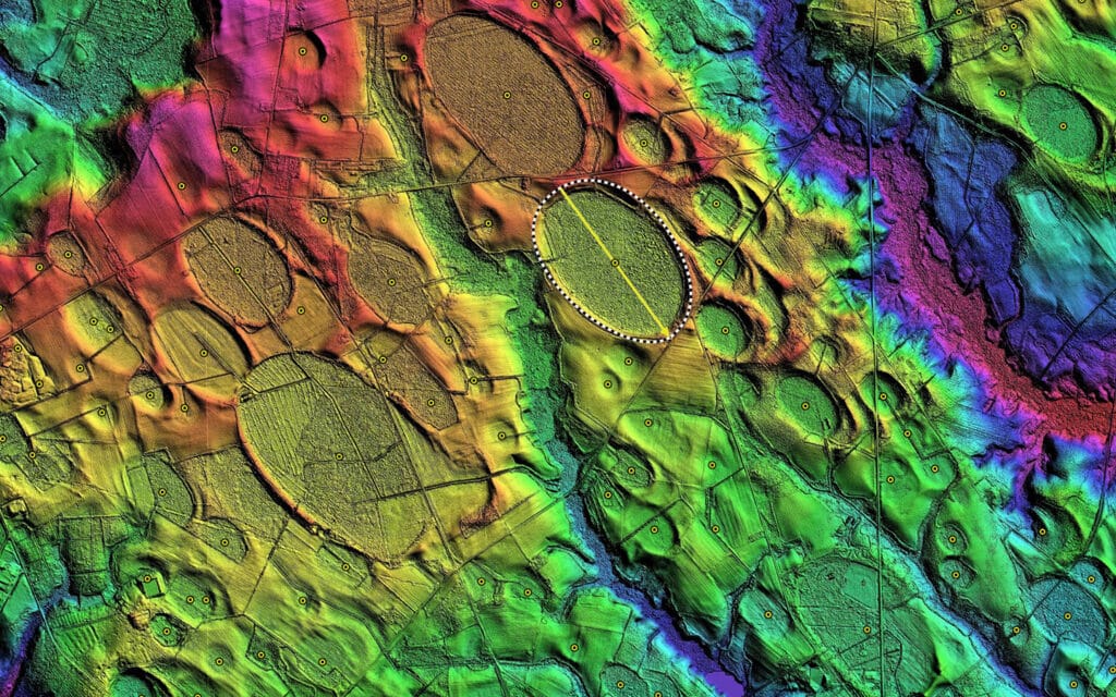
Viewed from the ground they could easily be overlooked. But when viewed from above, Carolina bays create a dramatic imprint on the landscape. They all have a distinct elliptical shape, with a northwest to southeast orientation. They could be described as the crop circles of the wetlands. And oddly, this wouldn’t be their only connection to extraterrestrial theories.

When aerial photography was used to survey farmland in the 1930s surveyors were surprised to see thousands of elliptical depressions across the Eastern Seaboard. Interest in their origin quickly grew, with hypotheses ranging from ocean currents, wind patterns and sinkholes, to meteor showers and prehistoric gigantic beavers.

The mystery of the Carolina bays reached a fever pitch in the 1950s, when a respected University of North Carolina geologist named William Prouty steadfastly contended that the bays were a result of a meteor or comet colliding with the Earth over 12,000 years ago. This idea made quite an impact, so to speak, and debate continued for years about the cosmic nature of Carolina bays. One popular theory links the extinction event known as the Younger Dryas extinction (the same one responsible for wiping out the mammoth) to the formation of Carolina bays, suggesting that the wind and debris created from a comet colliding with the Earth near the Great Lakes region caused the depressions that became the bays.

Exploding comets and mass extinctions make for quite a dramatic birth story. And while everyone enjoys a bit of drama in their tales, doubt about the cosmic creation of Carolina bays led scientists to investigate individual bays more closely. What they found turned out to be a much more earthly creation process.

For instance, if Carolina Bays were the result of a single impact event then they should all be the same age.

“Data negates they [Carolina Bays] were formed at the same time,” said Anthony Rodriguez, associate professor of coastal geology at UNC’s Institute of Marine Sciences in Morehead City.

Rodriguez, along with then-graduate student Matt Waters and UNC associate professor, Michael Piehler, set out to study the origin and evolution of Lake Mattamuskeet, a conglomeration of multiple Carolina Bays in Hyde County on the Albemarle-Pamlico peninsula. Not only did they find no evidence linking these Carolina bays to a cosmic event such as the Younger Dryas extinction, but they also discovered that Lake Mattamuskeet is much younger, by at least 6,000 years, than Carolina bays were assumed to be.

Instead of an icy comet raining onto the Earth, Rodriguez and his colleagues discovered that Lake Mattamuskeet had a fiery beginning. Their analysis of the lake showed that cycles of burning peat associated with dry periods in the climate caused a basin to form where water later accumulated. Winds transported sand and silt, shaping the rim into the characteristic elliptical pattern. And, ta-da, after 1,000 years or so you have a Carolina bay.

When asked about the celestial hypothesis about the origin of Carolina bays, Rodriguez says carefully, “I think in the scientific community it certainly is not believed to be the case. But there is still a subset of believers in a cosmic beginning.”

He has reason to be careful in his response. A web search on Carolina bays brings up multiple sites that provide personal theories touting their cosmic beginnings, interspersed with a limited number of sites detailing the current scientific understanding. It appears that by many, the belief in a cosmic origin is still as passionately supported as it was in the 1950s.

This is not lost of Rodriguez. Parents to similarly aged children, Rodriguez and Piehler were surprised to open their children’s science textbook at a school open house to find that Carolina bays are still being linked to cosmic events.

“On one hand, at least they were in there,” said Rodriguez. “But this just isn’t the case. We couldn’t believe that this is still being told about Carolina bays.”

Still, Rodriguez and his colleagues are cautious to apply the results of their study on Lake Mattamuskeet to explain the origin of other Carolina bays.

“Although we think Lake Mattamuskeet formed by a peat fire, and other bays also might have, they probably aren’t all formed this way,” said Rodriguez.

But he does believe that wind is the driving force in shaping most, if not all, Carolina bays into their characteristic elliptical shape.

“These are soft substrates that shift with wind direction over time. The old timers, from the ‘30s to ‘50s, if you draw a line along the long axis (of the Carolina bays they surveyed) that line shifts a little bit as you move farther south. This goes along with wind direction,” explained Rodriguez.

Despite the growing understanding of the origin of some Carolina bays, the vast majority of them have yet to be closely studied. Rodriguez notes that he has had difficulty receiving funding for additional studies on Carolina bays, causing him to table future research on other sites.

And while some are protected as state or national parks, many of the Carolina Bays are already gone. Over the years, thousands of Carolina Bays have been drained and turned into farmland, recreational spaces, or converted to roadways — erasing these unique geological and ecological formations — and taking the mystery of their origin with them.

Source

Loomis, C. (2013). The Fiery Origins of Carolina Bays. Coastal Review. Retrieved from https://coastalreview.org/2013/08/the-fiery-origins-of-carolina-bays/

New Rule to Protect State and Tribal Waters

Press Release:

The U.S. Environmental Protection Agency (EPA) announced a proposed rule that would streamline and clarify the requirements and steps necessary for states and Tribes to administer programs protecting waterways from discharges of dredged or fill material without a permit. The Clean Water Act envisions collaborative implementation between EPA and state and Tribal co-regulators to protect our nation’s waters that support public health, thriving ecosystems, business development, recreation, agriculture, and more. EPA’s proposal would address key barriers identified by states and Tribes to administering Clean Water Act section 404 while expanding opportunities for Tribes to meaningfully engage in permitting actions.

“Many state and Tribal partners share EPA’s goal of protecting our nations waterways as envisioned by Congress and embodied in the Clean Water Act. That’s why EPA is proposing this to strengthen our partnership with states and Tribes, ensuring clean water protections. Today’s proposal will support co-regulator efforts to administer their own programs to manage discharges of dredged or fill material into our nation’s waters.”

Radhika Fox, EPA Assistant Administrator for Water

Currently, three states administer their own Clean Water Act section 404 programs, which prohibit the discharge of dredged or fill material into a water of the United States without a permit. The last major update to these regulations occurred in 1988. This proposal responds to state and Tribal requests that EPA clarify the process to assume and administer the section 404 program, including which water bodies would be covered under the program and mitigation and enforcement responsibilities.

“The National Association of Wetland Managers (NAWM) supports efforts by EPA to clarify and expand opportunities for assumption of the Section 404 program. For many states and tribes, assumption can offer a way to improve protection of their wetlands and other aquatic resources. Program assumption can reduce duplicative state, Tribal and federal permitting requirements and increase integration with related water management programs.” 

Marla Stelk, National Association of Wetland Managers Executive Director

Proposed Rule Highlights:

Program Description

  • The proposal clarifies what should be included in the program description when a state or Tribe requests to assume the section 404 program.
  • The proposal provides direction on how a state or Tribe can demonstrate their program is consistent with and no less stringent than federal requirements, and how they can ensure and demonstrate that permits they issue are consistent with the substantive environmental permit review criteria as laid out by EPA for section 404 permits.

Retained Waters/ Adjacent Wetlands

  • The proposal responds to longstanding requests from states and Tribes seeking clarity about which waters they can assume, and which waters are retained by the Corps.
  • Consistent with current practice, when a state or Tribe assumes a section 404 program, project applicants should request permits from the Corps for discharges into retained waters and from the state or Tribe for discharges into assumed waters of the United States.

Program Approval and Withdrawal Procedures

  • The proposal responds to concerns from states that it can be challenging to immediately administer the program upon program approval.
  • The proposal provides for a default 30-day effective date between when EPA approves a state/Tribal section 404 program, and when the state or Tribe begins administering the program.
  • The proposal provides flexibility by allowing for the effective date to be extended to 120 days upon mutual agreement between EPA and the state or Tribe.
  • The proposal revises the current program withdrawal process to increase clarity and harmonize the withdrawal procedures with the approval procedures.

Compensatory Mitigation

  • The proposal clarifies state and Tribal responsibilities and requirements for compensatory mitigation and requires an opportunity for federal review of certain mitigation instruments established by the state or Tribe.

Long-term Permitting

  • The CWA limits state and Tribal permits to five years in length, but some projects extend well beyond five years.
  • The proposal provides a clear approach for state and Tribal permitting of long-term projects, while also providing for the consideration of the full scope of environmental impacts.

Compliance and Enforcement

  • The proposal clarifies that states and Tribes may prosecute violations under any criminal negligence standard, for purposes of state and Tribal CWA section 402 and 404 programs.

Resources:

Proposed Rule- Clean Water Act Section 404 Tribal and State Program Regulation

Proposed Rule Fact Sheet

EPA Press Release

Virginia DEQ: Wetland Permit Guidance

Republished from Virginia Mercury

Virginia’s Department of Environmental Quality released a memo last month detailing how it will approach reviews of applications for permits involving wetlands following a recent U.S. Supreme Court ruling that sharply limits the number of wetlands subject to federal protection.

Last month, the U.S. Supreme Court ruled that wetlands must have a surface connection to a larger navigable body of water, rather than only an underground connection, in order to be federally protected.

Virginia officials and environmental groups say the state already has strong laws on the books that provide broad protection of both tidal and non-tidal, or inland, wetlands. But the Supreme Court ruling in Sackett v. U.S. Environmental Protection Agency reduced federal involvement in reviewing protections and shifted more responsibility to states.

Jurisdictional Determinations

The biggest change Virginia will face is in handling jurisdictional determinations, or identifications of water body boundaries through a process known as delineation that is used to determine whether the government has oversight of a particular water. 

Previously, DEQ relied on the U.S. Army Corps of Engineers to make those determinations. That relationship was already in flux: In May, the Corps requested that all new applications for permits come with completed determinations, citing workload issues, and it paused determinations as the EPA sought a change to a rule defining what federal waters are. The Sackett ruling has exacerbated that situation, with the Corps unlikely to resume determinations until the new rule is finalized in light of the decision.

Amid uncertainty among developers on who will conduct the determinations and in anticipation of an increased workload to process applications with the loss of their federal partners, DEQ released the June 29 memo detailing its review process under the new interpretation of the law.

“At this time, the Department of Environmental Quality (DEQ) does not know how the U.S. Army Corps of Engineers (Corps) and U.S. Environmental Protection Agency (EPA) will implement the Sackett decision in permitting and delineation boundary decisions,” the memo states. “We anticipate that there may be new federal guidance, checklists, field procedures, regulations and other information made public in the future.”

Jeff Steers, Virginia Department of Environmental Quality

Permit Guidance

The memo says the agency will “strive” to review permit applications for projects that already have delineations within 30 days. Under DEQ’s new process, all delineations must be conducted by professional wetland delineators certified by the Department of Professional and Occupational Regulation. 

A footnote to the memo notes there are an estimated 118 professional wetlands delineators in Virginia, with over 100 in the private sector. 

DEQ will still accept applications with delineations identified by non-certified professional delinations, but the agency says it “cannot provide a time frame on how long that review will take.”

DEQ’s request for all delineations to be performed by certified professionals is a way for “projects to move forward in a timely manner,” a news release from the agency states.

“Balanced economic development and environmental protection are integrally linked,” said DEQ Director Michael Rolband in a statement. “We are doing everything possible to ensure that the Sackett decision does not harm Virginia’s growing economy or environment.”

Andrew Clark, vice president of government affairs for the Home Builders Association of Virginia, said that the Corps’ freeze on issuing approved jurisdictional determinations could extend into next year and have a “chilling effect” on development. 

“Jurisdictional determinations provide clarity on the legal and regulatory requirements applicable to a project and allow developers to identify site constraints that may impact community design, site planning, infrastructure placement, unit types, and density,” Clark said in an email. DEQ’s approach, he said, “will minimize permitting delays and regulatory uncertainty.”

Wetland Delineations

One avenue of uncertainty for wetlands protections is how the delineations will be made going forward.

Virginia state code requires delineations to follow guidance laid out in a 1987 manual from the U.S. Army Corps of Engineers. But even though Sackett has reduced the scope of the Corps’ oversight of wetlands, Jonathan Gendzier, a staff attorney at the Southern Environmental Law Center, said he hasn’t “heard of any” changes planned to the manual. 

The new review process outlined by DEQ is “applaudable,” said Chris French, a member of the Protect Hanover group that has been fighting for wetlands protections during the development of a Wegmans distribution facility outside Richmond, but the 30-day window may be a tight opportunity for a thorough review. Delineation decisions can be complicated and frequently require field verification, explained French.

The process is “pretty comprehensive,” French said. “For a large site like Wegmans, one company spent weeks on it. [DEQ] is trying to meet a need with the resources they have. You don’t want to have delays. You don’t want to have impacts to wetlands either. You have to ensure they’re complementary.” 

Maintaining Protection Efforts

Environmental groups like nonprofit Wetlands Watch say staffing levels at DEQ will also need to remain high to keep Virginia’s wetland protections intact. 

“Virginia doesn’t want to go back,” said Wetlands Watch Executive Director Mary-Carson Stiff. 

Peggy Sanner, Virginia executive director for the Chesapeake Bay Foundation, said DEQ has developed a “thoughtful process to help address the need for wetlands protection and permitting efficiency,” but added, “It is imperative that Virginia continues to safeguard wetlands that are no longer federally protected.”  

Martha Moore, vice president of government relations for the Virginia Farm Bureau, said Virginia’s guidance “is consistent with the [Sackett] ruling as it referred to the states to regulate, which Virginia already did.”

“DEQ, like a number of state agencies, has a lot of vacancies so I would assume this would [be] like any other regulatory program they administer that they have to utilize the resources they have,” Moore said. “I think the issue is finding people as opposed to not filling positions. They would need qualified people to help implement the regulatory requirements of all of their programs.”

Source

Paullin, C. (2023). Virginia offers wetland permit guidance following Supreme Court’s Sackett ruling. Virginia Mercury. Retrieved from https://www.virginiamercury.com/2023/07/14/virginia-offers-wetland-permit-guidance-following-supreme-courts-sackett-ruling/

Stressors Affecting Wetland Ecosystems

Wetlands are ecosystems with a wide array of soil types, vegetation, and water qualities, primarily determined by geographic location and climatic conditions. Some of the most common types of wetlands are floodplains, mangroves, salt marshes, peatlands, forests, and freshwater marshes. The wetlands are distributed widely across the landscape and are a fundamental constituent of US aquatic resources. Namely, wetlands are significant because these ecosystems filter pollutants from air and soil, store carbon, provide wildlife habitat, and prevent flooding. Additionally, wetlands are used locally as recreation areas. 

Stress Factors

Human Activities

Human activities significantly threaten the existence of wetlands and maintain these services. Humans take various steps that make life easier and better, such as agriculture and urban development, but at the same time, these actions endanger the wetlands. Also, several natural processes are stressors for the wetlands, such as erosion and flooding, jeopardizing wetlands in the US and the entire planet.

Wetlands usually occur as small isolated patches in mountain meadows and can be found as strips along rivers and streams and as large groups along the southern and eastern coasts of the US. The primary function of wetlands is absorbing runoff and filtering surface water, and in this process, wetlands collect excess sediment, nutrients, and other pollutants. These natural sponges support ecological processes, including hydrology, soil, and vegetation development. The surrounding area around the wetland should be minimally disturbed to provide the best results. Consequently, the “buffer” area will directly impact the overall ecological condition.   

Human activities substantially affect climate change and, at the same time, intensify the stressors. As a result of long-term shifts in temperatures and weather patterns, the frequency of occurrence of extreme precipitation and droughts has increased, and the sea levels are progressively rising. For example, an inland wetland, the Prairie Pothole Region in the north-central part of the US, provides a breeding environment for more than 50% of North American waterfowl species. In the past, this area has experienced temporary droughts, and if the trend of dry periods continues, scientists predict a dramatic drop in waterfowl breeding grounds.

Rising Sea Level

Increased sea levels immensely stress the coastal wetlands due to the saltwater invasion (increased salinity), reduced barriers to storm surges, and increased erosion. When the physical conditions in the wetlands change, plants and animals respond to those changes. Some local species could become extinct, and others expand their range, thus distressing the balance. By monitoring the plant changes, scientists can notice early warning signs of environmental changes and respond appropriately. When joined with the predicted erosion rates due to sea-level rise, current levels of wetlands will exponentially decrease. They will no longer serve as natural barriers to flooding during natural disasters.

Wetland Loss

Despite all efforts, statistical data shows that annually the United States loses about 60,000 acres of wetlands. If you find it difficult to imagine the size of that area – that’s almost equal to 35,000 football fields!

What can you do to protect the wetlands? You can start locally with these five simple and essential steps.