A day in the life of a wetland scientist

In the field, the wetland scientist engages in a variety of specialized tasks, including soil sampling to identify hydric soils, conducting thorough vegetation surveys, and assessing wetland hydrology through both direct and indirect means. These activities require a keen eye for detail, extensive knowledge of wetland ecosystems, and the ability to work effectively in challenging outdoor conditions. Additionally, the role involves meaningful interactions with local communities, landowners, and regulatory bodies, emphasizing the importance of wetlands in ecological balance and sustainable land use.

The day of a wetland scientist is not just about fieldwork; it also involves critical analysis and documentation back at the office or lab. Here, the scientist delves into data interpretation, report writing, and consultation with environmental experts, ensuring that their findings contribute to broader conservation efforts and comply with environmental regulations. The narrative also emphasizes the importance of continuous learning and professional development in the field of wetland science. This commitment to staying abreast of the latest research, technological advancements, and regulatory changes is vital for effective wetland management and protection.

  • Early Morning Research and Preparation: The scientist’s day begins with reviewing satellite images, wetland delineation protocols, and local environmental regulations. They ensure that all their equipment, including soil coring tools and water quality kits, is ready for the day.
  • Travel to the Wetland Site: The journey to the wetland site might be an adventure, often traversing through less-traveled paths. The scientist plans their route, considering the day’s objectives and the logistics of reaching the site.
  • Initial Site Assessment: Upon arrival at the wetland, the scientist conducts an initial survey, looking for visible indicators of wetland boundaries and making preliminary notes.
  • Detailed Wetland Delineation Work: The morning is spent in intense fieldwork, including soil sampling, vegetation identification, and hydrology assessment, to accurately delineate the wetland boundaries.
  • Fun and Exploratory Lunch Break: By midday, it’s time for a well-deserved break. The scientist often takes this opportunity to explore local eateries, enjoying the chance to discover unique and interesting restaurants in the area. This lunch break becomes a mini-adventure, offering a delightful pause from the fieldwork and a chance to savor the local cuisine.
  • Post-Lunch Delineation and Data Collection: After lunch, the scientist returns to the field, possibly revisiting certain areas for additional verification or moving to new sections for further delineation.
  • Community Interaction and Educational Outreach: The afternoon may also include interactions with local communities, landowners, or educational groups, discussing the day’s findings and the importance of wetland conservation.
  • Return to Base for Analysis and Reporting: Back at their office or lab, the scientist analyzes the collected data, begins processing samples, and starts drafting reports based on the day’s delineation work.
  • Consultations and Collaborations: The scientist might consult with environmental agencies or collaborate with colleagues, ensuring that the delineation aligns with regulatory standards and contributes to broader environmental research.
  • Evening Review, Planning, and Networking: The day concludes with a review of the work done, updating project files, and perhaps participating in professional networking activities, staying connected with the wider scientific community.
  • Continued Learning and Research: The scientist spends time in the evening catching up on the latest research in wetland ecology and planning for future professional development opportunities.
  • Relaxation and Personal Time: Finally, the scientist unwinds, reflecting on the day’s work and the culinary adventure they enjoyed at lunch, recharging for the next day’s challenges.

Streamflow Duration Assessment Methods (SDAMs)

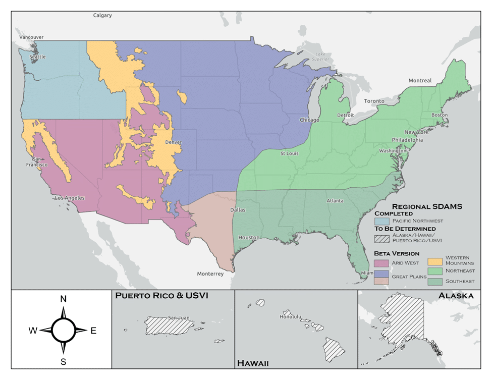
The U.S. Army Corps of Engineers (USACE) has developed the Streamflow Duration Assessment Methods (SDAMs), currently in their interim phase, to enhance the management and protection of water resources. This interim phase, reflecting a period of testing and refinement, is crucial for ensuring the accuracy and effectiveness of these methods.

Understanding the Interim Phase of SDAMs

The interim phase of the SDAMs, is a dynamic period where the methods are being field-tested, evaluated, and improved. This phase allows for the incorporation of feedback from various stakeholders, including environmental scientists, water resource managers, and policy makers.

The Role and Importance of SDAMs

Streamflow Duration Assessment Methods are essential for classifying streams based on the duration and frequency of their flow. This classification is vital for:

  1. Environmental Conservation: Assessing the impact of streamflow on aquatic ecosystems.
  2. Water Resource Management: Informing decisions related to water rights, usage, and allocation.
  3. Land Development: Guiding development projects to minimize adverse effects on water resources.
  4. Regulatory Compliance: Aiding in adherence to environmental regulations, such as the Clean Water Act in the U.S.

Implementation Strategies During the Interim Phase

During this interim phase, USACE employs various strategies:

  • Pilot Studies: Conducting field tests in diverse geographical locations to understand the method’s applicability.
  • Stakeholder Feedback: Actively seeking input from users to refine the methods.
  • Data Collection and Analysis: Gathering and analyzing extensive data to validate and improve the methods.
  • Technological Integration: Incorporating advanced technologies such as remote sensing and hydrological modeling.

Challenges and Future Outlook

The interim phase faces challenges like dealing with the impacts of climate change and the need for robust data. Looking ahead, the focus will likely be on:

  • Refining Models: Enhancing the precision and reliability of the methods.
  • Climate Adaptation: Incorporating climate change projections more comprehensively.
  • Expanding Collaboration: Increasing engagement with a broader range of stakeholders.

The U.S. Army Corps of Engineers’ (USACE) Streamflow Duration Assessment Methods (SDAMs) play a significant role in determinations related to the Waters of the United States (WOTUS). WOTUS is a term used in U.S. federal environmental regulations that defines the bodies of water that fall under the jurisdiction of the Clean Water Act (CWA). Understanding this relationship is crucial for environmental protection, water resource management, and compliance with federal laws.

The Role of SDAMs in WOTUS Determinations

  1. Defining Jurisdictional Waters: SDAMs are instrumental in determining whether a particular stream or water body falls under the category of WOTUS. By assessing the duration and frequency of streamflow, these methods help to classify streams as perennial, intermittent, or ephemeral, which is a key factor in WOTUS determinations.
  2. Environmental Regulation Compliance: The classification of water bodies as WOTUS has significant implications for environmental regulation, particularly in terms of permitting, pollution control, and habitat protection under the CWA.
  3. Impact on Land Use and Development: SDAMs influence decisions on land use and development. Projects near water bodies classified as WOTUS might require additional permits and environmental assessments to ensure compliance with the CWA.
  4. Protection of Aquatic Ecosystems: By aiding in the identification of WOTUS, SDAMs contribute to the protection of aquatic ecosystems, especially those dependent on certain streamflow conditions.

Challenges and Complexities in WOTUS Determinations

  1. Changing Definitions and Regulations: The definition of WOTUS has been subject to changes and legal challenges over the years, affecting how SDAMs are applied in regulatory contexts.
  2. Interagency Collaboration: WOTUS determinations often require collaboration between the USACE, the Environmental Protection Agency (EPA), and other federal and state agencies, necessitating a harmonized approach to streamflow assessment.
  3. Site-Specific Assessments: SDAMs need to be adaptable to various geographical and climatic conditions, as streamflow characteristics can vary significantly across different regions.
  4. Incorporating Climate Change Impacts: With changing climate patterns, the assessment of streamflow duration may become more complex, affecting WOTUS determinations over time.

Conclusion

The USACE’s Streamflow Duration Assessment Methods, in their critical interim phase, represent a significant step forward in sustainable water resource management. As these methods evolve, they will play an increasingly important role in protecting and managing water resources effectively for future generations. The ongoing development and refinement during this interim phase, while challenging, are essential for the creation of reliable and universally applicable streamflow assessment tools.

The Streamflow Duration Assessment Methods are deeply intertwined with the determinations of Waters of the United States. They provide a scientific and systematic approach to classifying water bodies, which is fundamental for regulatory compliance, environmental protection, and informed decision-making in land development. As environmental policies and climate conditions continue to evolve, the role of SDAMs in WOTUS determinations remains a key aspect of sustainable water resource management.

EPA and the Department of the Army issue Amended Final Rule Defining WOTUS

By Rick Savage – Carolina Wetlands Association

On August 29, 2023, the U.S. Environmental Protection Agency (EPA) and the Department of the Army announced a final rule that amends the January 2023 definition of “waters of the United States” (WOTUS). The amendments conform the January 2023 definition to the U.S. Supreme Court’s decision in Sackett and will take effect immediately upon publishing in the Federal Register (likely to happen within two weeks)To read the pre-publication version of the revised final rule, go to Pre-publication Version of the Final Rule – Amendments to the Revised Definition of Waters of the United States (epa.gov)

While exact details are yet to be digested, the gist of the ruling is becoming clear.  First, the significant nexus rule has been eliminated; so isolated wetlands are not jurisdictional wetlands, meaning they are not protected under the Clean Water Act.  Second, the new rule requires visual evidence of a continuous surface flow between a wetland and navigable water.  This part of the rule can get complicated as to what constitutes visual evidence of continuous surface flow.  I am sure that this will cause a lot of confusion and some developers will say there is no continuous surface flow and impact the wetland with a permit. 

Suffice it to say, this puts wetlands in North and South Carolina in jeopardy. The NC Department of Environmental Quality has estimated about 2.5 million acres of wetland have lost protection in North Carolina and I am sure a similar number in South Carolina.  The NC legislature could have continued to protect these wetlands; however, the recently passed Farm Bill eliminated state protection of isolated wetlands.   

We all need to brace ourselves for a lot of wetland loss and they are the very resource we need to protect our communities from flooding.  I think it is reasonable to expect more communities to get flooded, to have less clean water, and to have reduced climate resilience as well as miss the many other benefits that our wetlands provide. 

So go out an explore a wetland (before it gets developed?).

August 2023 Definition of Waters of the United States

On August 29, 2023 the US EPA and the US Army Corps of Engineers released a pre-publication version of the conforming amendment to the 2023 definition a Waters of the US. I cannot recall ever having seen a “conforming amendment” in all my years working with this issue. In fact, I am not sure it has ever been done before in any circumstance. I expect the next round of challenges to this rule will focus on this.

The final version of this rule is the weakest version of the Waters of the US we have ever had. The amount of wetlands no longer covered by Clean Water Act protections is the lowest it has ever been including the Navigable Waters Protection Rule era. It is also important to note that the Supreme Court Decision that prompted this new rule was a unanimous (9-0) one. All nine justices were in agreement despite popular media decrying it was the right side of the bench that dominated the Decision.

This is a final rule and becomes effective on the date it is published in the Federal Register. There is no public comment period. I am still unclear as to why the agencies are in such a hurry to not regulate wetlands.

Much of the new rule discusses why it is proper to issue a conforming amendment without a public comment period. The rule itself is fairly brief, in that it provides the edits to the existing Biden rule. The rule itself does not merge the two rules together into a single document. They leave that up to you. However, we have done this for you and the total new conforming rule follows. We will also be hosting a webinar on this new rule on September 28, 2023. Hope to see you there!

Title 33 —Navigation and Navigable Waters

Chapter II —Corps of Engineers, Department of the Army, Department of Defense

Part 328 —Definition of Waters of the United States

Authority: 33 U.S.C. 1251 et seq.

Source: 51 FR 41250, Nov. 13, 1986, unless otherwise noted.

§ 328.3 Definitions.

For the purpose of this regulation these terms are defined as follows:

(a) Waters of the United States means:

(1) Waters which are:

(i)  Currently used, or were used in the past, or may be susceptible to use in interstate or foreign commerce, including all waters which are subject to the ebb and flow of the tide;

(ii) The territorial seas; or

(iii) Interstate waters,

(2)  Impoundments of waters otherwise defined as waters of the United States under this definition, other than impoundments of waters identified under paragraph (a)(5) of this section;

(3) Tributaries of waters identified in paragraph (a)(1) or (2) of this section that are relatively permanent, standing or continuously flowing bodies of water;

(4) Wetlands adjacent to the following waters:

(i) Waters identified in paragraph (a)(1) of this section; or

(ii) Relatively permanent, standing or continuously flowing bodies of water identified in paragraph (a)(2) or (a)(3) of this section and with a continuous surface connection to those waters.

(5) Intrastate lakes and ponds not identified in paragraphs (a)(1) through (4) of this section that are relatively permanent, standing or continuously flowing bodies of water with a continuous surface connection to the waters identified in paragraph (a)(1) or (a)(3) of this section.

(b)  The following are not “waters of the United States” even where they otherwise meet the terms of paragraphs (a)(2) through (5) of this section:

(1)  Waste treatment systems, including treatment ponds or lagoons, designed to meet the requirements of the Clean Water Act;

(2)  Prior converted cropland designated by the Secretary of Agriculture. The exclusion would cease upon a change of use, which means that the area is no longer available for the production of agricultural commodities. Notwithstanding the determination of an area’s status as prior converted cropland by any other Federal agency, for the purposes of the Clean Water Act, the final authority regarding Clean Water Act jurisdiction remains with EPA;

(3)  Ditches (including roadside ditches) excavated wholly in and draining only dry land and that do not carry a relatively permanent flow of water;

(4) Artificially irrigated areas that would revert to dry land if the irrigation ceased;

(5)  Artificial lakes or ponds created by excavating or diking dry land to collect and retain water and which are used exclusively for such purposes as stock watering, irrigation, settling basins, or rice growing;

(6)  Artificial reflecting or swimming pools or other small ornamental bodies of water created by excavating or diking dry land to retain water for primarily aesthetic reasons;

(7)  Waterfilled depressions created in dry land incidental to construction activity and pits excavated in dry land for the purpose of obtaining fill, sand, or gravel unless and until the construction or excavation operation is abandoned and the resulting body of water meets the definition of waters of the United States; and

(8)  Swales and erosional features (e.g., gullies, small washes) characterized by low volume, infrequent, or short duration flow.

(c) In this section, the following definitions apply:

(1)  Wetlands means those areas that are inundated or saturated by surface or ground water at a frequency and duration sufficient to support, and that under normal circumstances do support, a prevalence of vegetation typically adapted for life in saturated soil conditions. Wetlands generally include swamps, marshes, bogs, and similar areas.

(2)  Adjacent means having a continuous surface connection.

(3)  High tide line means the line of intersection of the land with the water’s surface at the maximum height reached by a rising tide. The high tide line may be determined, in the absence of actual data, by a line of oil or scum along shore objects, a more or less continuous deposit of fine shell or debris on the foreshore or berm, other physical markings or characteristics, vegetation lines, tidal gages, or other suitable means that delineate the general height reached by a rising tide. The line encompasses spring high tides and other high tides that occur with periodic frequency but does not include storm surges in which there is a departure from the normal or predicted reach of the tide due to the piling up of water against a coast by strong winds such as those accompanying a hurricane or other intense storm.

(4)  Ordinary high water mark means that line on the shore established by the fluctuations of water and indicated by physical characteristics such as clear, natural line impressed on the bank, shelving, changes in the character of soil, destruction of terrestrial vegetation, the presence of litter and debris, or other appropriate means that consider the characteristics of the surrounding areas.

(5)  Tidal waters means those waters that rise and fall in a predictable and measurable rhythm or cycle due to the gravitational pulls of the moon and sun. Tidal waters end where the rise and fall of the water surface can no longer be practically measured in a predictable rhythm due to masking by hydrologic, wind, or other effects.

Half Of The U.S. No Longer Subject To The New WOTUS Rule

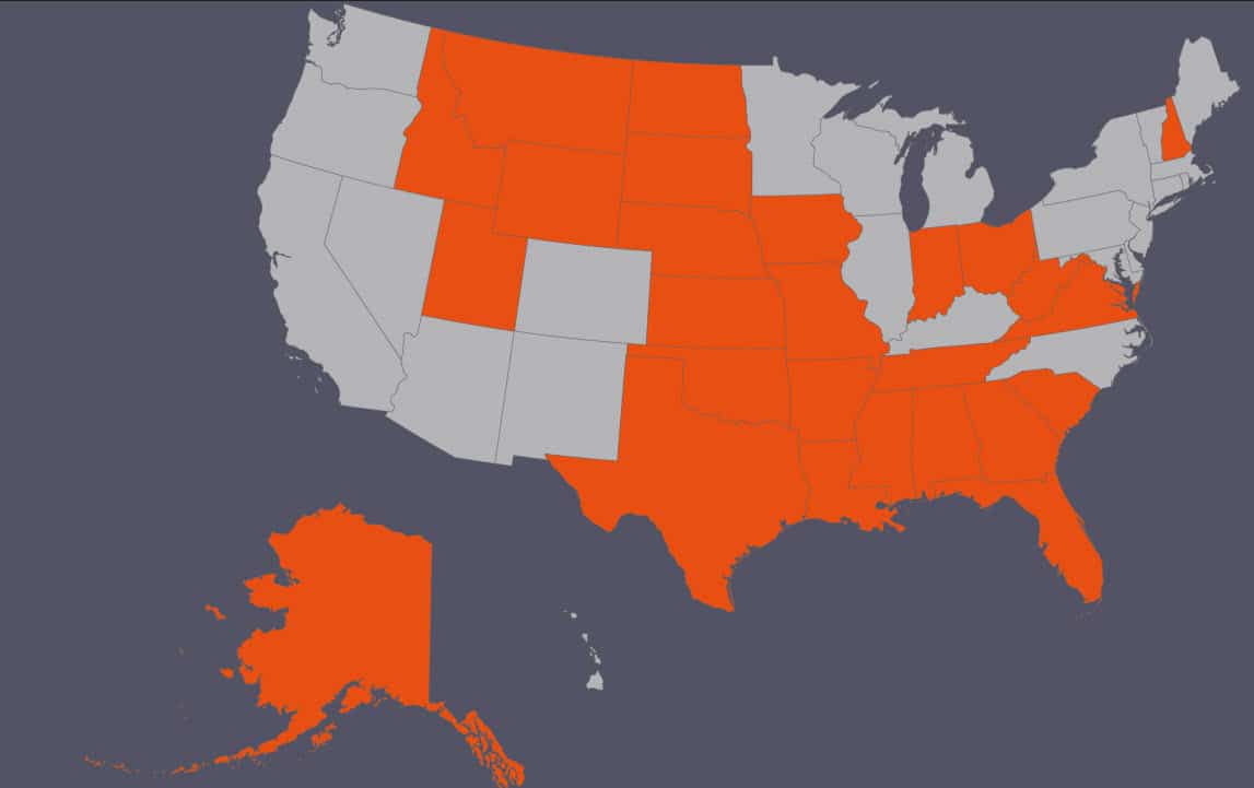
On April 12, 2023, Daniel L. Hovland, a federal judge in North Dakota, temporarily blocked the implementation of the latest “Waters of the United States” (WOTUS) rule. This action affects 24 states and is on the heels of a previous ruling by Jeffrey Vincent Brown, another federal judge for the southern district of Texas, that now excludes Texas and Idaho from the new WOTUS rule. At issue is the codification of the significant nexus test. According to two judges, the new 2023 rule that the balance of harms weighs towards the States. It benefits the public to “ensure that federal agencies do not extend their power beyond the express delegation from Congress.”

Where is WOTUS not in use?

  • West Virginia
  • North Dakota
  • Georgia
  • Iowa
  • Alabama
  • Alaska
  • Arkansas
  • Florida
  • Indiana
  • Kansas
  • Louisiana
  • Mississippi
  • Missouri
  • Montana
  • Nebraska
  • New Hampshire
  • Ohio
  • Oklahoma
  • South Carolina
  • South Dakota
  • Tennessee
  • Utah
  • Virginia
  • Wyoming
  • Texas
  • Idaho

Implications for these states

The impact of the outcome of the Sackett case by the Supreme Court (SCOTUS) is the driver for these two decisions. At issue there is a need to have a new rule before the SCOTUS ruling. A revised rule will clarify whether the Rapanos version of the “significant nexus” test is an appropriate exercise of the EPA’s jurisdiction under the Clean Water Act.

Neither the federal government nor the States know what the controlling test is, and Supreme Court precedent to date has been of scant assistance.  Hopefully, the Supreme Court decision in Sackett will provide some clarity.  The outcome of the Sackett  case may have significant implications for the EPA’s authority to determine jurisdictional waters under the Clean Water Act.  It may also determine the EPA’s ability to enforce the 2023 WOTUS Rule.  Until then, every state will continue to swim in waters of uncertainty, ambiguity, and chaos.

Daniel L. Hovland, District Judge United States District Court

Which definition are they using?

Working in these states is a bit unclear as to which definition should be used. Presumably, the last standing definition was the WOTUS recodification rule of 2019. This rule preceded the infamous 2020 Navigable Waters Rule, which was remanded and vacated in 2021.

It will be difficult to obtain permits and authorizations if federal agencies can’t use the 2023 WOTUS rule in half of the U.S. There is no clarity as to what constitutes a jurisdictional water body, making permitting almost impossible.

We expect a decision on the Sackett case from SCOTUS by the end of the term in June. Even if the Court provides a decision, there is no doubt that the next set of court cases against EPA and the Corps will be to challenge that the 2023 rule is inconsistent with the SCOTUS decision, whatever it may be.

Sources

Fischler, J. (2023). Federal judge temporarily blocks new Biden WOTUS rule in two dozen states. Ohio Capital Journal. Retrieved from: https://ohiocapitaljournal.com/2023/04/18/federal-judge-temporarily-blocks-new-biden-wotus-rule-in-two-dozen-states/

2023 Waters of the United States

This week, the new Waters of the U.S. (WOTUS) rule was enacted. On December 30, 2022, the agencies announced the final “revised definition of ‘waters of the United States” rule. The rule was published in the Federal Register on January 18, 2023, and became effective on March 20, 2023.

The agencies developed this rule with consideration to the relevant provisions of the Clean Water Act and the statute as a whole, relevant Supreme Court case law, and the agencies’ technical expertise after more than 45 years of implementing the longstanding pre-2015 “waters of the United States” framework. This rule also considers the best available science and extensive public comment to establish a definition of “waters of the United States” that supports public health, environmental protection, agricultural activity, and economic growth.

There are numerous lawsuits and challenges to this rule. These come from both sides of the aisle and include several lobbying groups, environmental organizations, states, and tribes. In addition, we are still waiting to hear from the U.S. Supreme Court on the now-infamous Sackett case. This case directly challenges the new WOTUS rule.
The following is the new WOTUS rule. There are several pages associated with the rule, but this is the meat of it.

Part 328 Definition of Waters of the United States- Regulatory Text

  1. The authority citation for part 328 continues to read as follows:
    • Authority: 33 U.S.C. 1251 et seq.

Definitions

  1. Revise § 328.3 to read as follows:
    • For the purpose of this regulation these terms are defined as follows:
      • a) Waters of the United States means:
        • 1) Waters which are:
          • (i) Currently used, or were used in the past, or may be susceptible to use in interstate or foreign commerce, including all waters which are subject to the ebb and flow of the tide;
          • (ii) The territorial seas; or
          • (iii) Interstate waters, including interstate wetlands;
        • (2) Impoundments of waters otherwise defined as waters of the United States under this definition, other than impoundments of waters identified under paragraph (a)(5) of this section;
        • (3) Tributaries of waters identified in paragraph (a)(1) or (2) of this section:
          • (i) That are relatively permanent, standing or continuously flowing bodies of water; or
          • (ii) That either alone or in combination with similarly situated waters in the region, significantly affect the chemical, physical, or biological integrity of waters identified in paragraph (a)(1) of this section;
        • (4) Wetlands adjacent to the following waters:
          • (i) Waters identified in paragraph (a)(1) of this section; or
          • (ii) Relatively permanent, standing or continuously flowing bodies of water identified in paragraph (a)(2) or (a)(3)(i) of this section and with a continuous surface connection to those waters; or
          • (iii) Waters identified in paragraph (a)(2) or (3) of this section when the wetlands either alone or in combination with similarly situated waters in the region, significantly affect the chemical, physical, or biological integrity of waters identified in paragraph (a)(1) of this section;
        • (5) Intrastate lakes and ponds, streams, or wetlands not identified in paragraphs (a)(1) through (4) of this section:
          • (i) That are relatively permanent, standing or continuously flowing bodies of water with a continuous surface connection to the waters identified in paragraph (a)(1) or (a)(3)(i) of this section; or
          • (ii) That either alone or in combination with similarly situated waters in the region, significantly affect the chemical, physical, or biological integrity of waters identified in paragraph (a)(1) of this section.
    • (b) The following are not “waters of the United States” even where they otherwise meet the terms of paragraphs (a)(2) through (5) of this section:
      • (1) Waste treatment systems, including treatment ponds or lagoons, designed to meet the requirements of the Clean Water Act;
      • (2) Prior converted cropland designated by the Secretary of Agriculture. The exclusion would cease upon a change of use, which means that the area is no longer available for the production of agricultural commodities. Notwithstanding the determination of an area’s status as prior converted cropland by any other Federal agency, for the purposes of the Clean Water Act, the final authority regarding Clean Water Act jurisdiction remains with EPA;
      • (3) Ditches (including roadside ditches) excavated wholly in and draining only dry land and that do not carry a relatively permanent flow of water;
      • (4) Artificially irrigated areas that would revert to dry land if the irrigation ceased;
      • (5) Artificial lakes or ponds created by excavating or diking dry land to collect and retain water and which are used exclusively for such purposes as stock watering, irrigation, settling basins, or rice growing;
      • (6) Artificial reflecting or swimming pools or other small ornamental bodies of water created by excavating or diking dry land to retain water for primarily aesthetic reasons;
      • (7) Waterfilled depressions created in dry land incidental to construction activity and pits excavated in dry land for the purpose of obtaining fill, sand, or gravel unless and until the construction or excavation operation is abandoned and the resulting body of water meets the definition of waters of the United States; and
      • (8) Swales and erosional features ( e.g., gullies, small washes) characterized by low volume, infrequent, or short duration flow.
    • (c) In this section, the following definitions apply:
      • (1) Wetlands means those areas that are inundated or saturated by surface or ground water at a frequency and duration sufficient to support, and that under normal circumstances do support, a prevalence of vegetation typically adapted for life in saturated soil conditions. Wetlands generally include swamps, marshes, bogs, and similar areas.
      • (2) Adjacent means bordering, contiguous, or neighboring. Wetlands separated from other waters of the United States by man-made dikes or barriers, natural river berms, beach dunes, and the like are “adjacent wetlands.”
      • (3) High tide line means the line of intersection of the land with the water’s surface at the maximum height reached by a rising tide. The high tide line may be determined, in the absence of actual data, by a line of oil or scum along shore objects, a more or less continuous deposit of fine shell or debris on the foreshore or berm, other physical markings or characteristics, vegetation lines, tidal gages, or other suitable means that delineate the general height reached by a rising tide. The line encompasses spring high tides and other high tides that occur with periodic frequency but does not include storm surges in which there is a departure from the normal or predicted reach of the tide due to the piling up of water against a coast by strong winds such as those accompanying a hurricane or other intense storm.
      • (4) Ordinary high water mark means that line on the shore established by the fluctuations of water and indicated by physical characteristics such as clear, natural line impressed on the bank, shelving, changes in the character of soil, destruction of terrestrial vegetation, the presence of litter and debris, or other appropriate means that consider the characteristics of the surrounding areas.
      • (5) Tidal waters means those waters that rise and fall in a predictable and measurable rhythm or cycle due to the gravitational pulls of the moon and sun. Tidal waters end where the rise and fall of the water surface can no longer be practically measured in a predictable rhythm due to masking by hydrologic, wind, or other effects.
      • (6) Significantly affect means a material influence on the chemical, physical, or biological integrity of waters identified in paragraph (a)(1) of this section. To determine whether waters, either alone or in combination with similarly situated waters in the region, have a material influence on the chemical, physical, or biological integrity of waters identified in paragraph (a)(1) of this section, the functions identified in paragraph (c)(6)(i) of this section will be assessed and the factors identified in paragraph (c)(6)(ii) of this section will be considered:
        • (i) Functions to be assessed:
          • (A) Contribution of flow;
          • (B) Trapping, transformation, filtering, and transport of materials (including nutrients, sediment, and other pollutants);
          • (C) Retention and attenuation of floodwaters and runoff;
          • (D) Modulation of temperature in waters identified in paragraph (a)(1) of this section; or
          • (E) Provision of habitat and food resources for aquatic species located in waters identified in paragraph (a)(1) of this section;
        • (ii) Factors to be considered:
          • (A) The distance from a water identified in paragraph (a)(1) of this section;
          • (B) Hydrologic factors, such as the frequency, duration, magnitude, timing, and rate of hydrologic connections, including shallow subsurface flow;
          • (C) The size, density, or number of waters that have been determined to be similarly situated;
          • (D) Landscape position and geomorphology; and
          • (E) Climatological variables such as temperature, rainfall, and snowpack.

Army Corps Halts Coverage Under Nationwide Permits

Several weeks ago, landowners and permit applicants received an email notification regarding the Clean Water Act (CWA) Section 404 Nationwide Permits (NWPs). Namely, according to the notice, the Army Corps of Engineers (Army Corps) would not clarify any coverage requests under a variety of CWA Section 404 NWPs.

The Clean Water Act Section 404 NWPs are the general permits that authorize activities under the previously mentioned act, which “will cause only minimal adverse environmental effects when performed separately, and will have only minimal cumulative adverse effects on the environment.”

In the email from the Army Corps, it is stated: 

We were informed today that due to the decision of the United States District Court for the Northern District of California on October 21, 2021, to remand USEPA’s 2020 CWA 401 rule with vacatur, the U.S. Army Corps of Engineers is not finalizing any permit decisions that rely on a certification or waiver under the 2020 rule at this time. The Corps is working to provide more refined guidance that provides a way forward that allows us to finalize permit decisions. (Emphasis added) 

All interested parties can find this informal notification on at least one government website in the “Latest News” section.

However, following the current developments, the agency has not issued a formal notice or press release yet, which has halted coverage under its NWP program. The Army Corps finalized the NWPs list in January 2021, and the entire list went through formal notice and comment rulemaking. Before being issued, the NWPs were subject to the CWA Section 401 certification process. Nevertheless, this move affects the following 16 NWPs:

12. Oil or Natural Gas Pipeline Activities
21. Surface Coal Mining Activities
29. Residential Developments
39. Commercial and Institutional Developments
40. Agricultural Activities
42. Recreational Facilities
43. Stormwater Management Facilities
44. Mining Activities
48. Commercial Shellfish Mariculture Activities
50. Underground Coal Mining Activities
51. Land-Based Renewable Energy Generation Facilities
52. Water-Based Renewable Energy Generation Pilot Projects
55. Seaweed Mariculture Activities
56. Finfish Mariculture Activities
57. Electric Utility Line and Telecommunications Activities
58. Utility Line Activities for Water and Other Substances

Information worth mentioning is the fact that the Army Corps’ notification was published weeks after EPA’s announcement that the Northern District of California court decision “requires a temporary return to EPA’s 1986 rule until EPA finalizes a new certification rule.” It is still unclear why the N.D. of California decision would result in a nationwide vacatur of the 401 Rule or why that court decision would affect NWPs. The NWPs were properly promulgated, and the procedure was based on the law that was in effect at the time. To date, there is no official explanation by any agency. In fact, there is no consideration or conclusion by any court that NWPs, or the Section 401 certifications issued for them, are unlawful.

Another circumstance that raises questions is the Senate vote 92-5 to confirm Michael Connor to serve as the assistant secretary of the Army for civil works. The notification was issued on the same date as the confirmation of Mr. Connor, so it is unknown whether he ordered the halt in permitting. Without any doubt, Mr. Connor has the power to make headway on the administration’s infrastructure, resilience, and climate goals, which in fact, will be hindered by the significant uncertainty left on its account. We can summarize that, until further notice, NWP coverage will not be granted for stormwater management projects, land- or water-based renewable energy projects; or electric, telecommunications, or water utility line activities, as well as residential, commercial, industrial, agricultural, and recreational activities.

In the meantime, until the government comes up with a solution and a decision on this matter, landowners and project proponents have an option to apply for an individual CWA Section 404 permit. The NWP process is designed to streamline the process for those activities with minimal environmental impact. As for comparison, the NWP process usually takes 60 days to be finished, while an individual permit can take up to one year or more. Annually, the Army Corps grants CWA Section 404 general permit coverage for more than 50,000 activities, and in the same period, issues on average 2,500 individual CWA 404 permits.     

This Army Corps’ notification raises many questions. First of all, it is unknown how long it will last the process of “providing more refined guidance”? Is there a need for changes and new programmatic Section 401 certifications for the NWPs mentioned above? Will the agency be on the lookout for those certifications before coverage can be granted? If the answer is YES, what changes will follow? There are two possibilities for the development: re-promulgation of NWPs, which would include new certification conditions; and the second option is the agency to strive for adding new conditions without going through the rulemaking process? Until the EPA comes up with a new certification rule, it remains unclear whether the agency will require each of the activities authorized under CWA Section 404 to receive an individual Section 401 certification.  

Property owners and project proponents are directly affected by this situation because of the potentially delayed certification process with individual permit applications. This, however, is quite a different sort of problem than halting coverage under already-issued NWPs. 

There has also been some unofficial information that the Corps has already reinstated the Nationwide permit review. However, as they have not confirmed that the Nationwide permits were put on hold they have not announced any further updates. There is a lot of confusion on this matter and it is highly recommended that you check with your local Corps District to confirm if the Nationwides in question are available for your region. There seems to be a high variability between districts as to the status of the the Nationwide program.

Waters of the State

The Swamp Stomp

Volume 15, Issue 42

On Friday, October 9, 2015 the United States Court of Appeals for the Sixth Circuit issued a stay of the US Environmental Protection Agency’s (EPA) and the US Army Corps of Engineers’ (Corps) new rule defining the scope of federal jurisdiction under the Clean Water Act (The Clean Water Rule). Until we hear otherwise, the Clean Water Rule is no longer in effect across the entire nation. The nationwide stay may be short-lived, and is contingent upon how the Sixth Circuit answers the key question regarding its own jurisdiction. There is a briefing on the jurisdictional issue is scheduled for completion on November 4, and the court indicated that its decision could be issued “in a matter of weeks.”

There are two sets of state lawsuits that have arisen as a result of the August, 28, 2015 Clean Water Rule. The first was alliance of 18 states (Alabama, Florida, Georgia, Indiana, Kansas, Kentucky, Louisiana, Michigan, Mississippi, North Carolina, Ohio, Oklahoma, South Carolina, Tennessee, Texas, Utah, West Virginia, and Wisconsin) that filed motions with the Court seeking (1) a stay of the rule during the pendency of the court’s proceedings and (2) a ruling from the Sixth Circuit that it lacked jurisdiction to hear their appeals (enabling pursuit of their cases before the district courts). On July 28, 2015, the U.S. Judicial Panel on Multidistrict Litigation consolidated all Court of Appeals cases in the Sixth Circuit.

On August 27, 2015, the U.S. District Court for North Dakota granted such a motion filed by a second set of 13 states (Alaska, Arizona, Arkansas, Colorado, Idaho, Missouri, Montana, North Dakota, Nebraska, Nevada, South Dakota, Wyoming, and New Mexico). This was one day before the new Clean Water rules was set to go into effect. On September 4, 2015, the court clarified that the rule was enjoined only in the 13 plaintiff states, not nationwide. The EPA and the Corps promptly informed the public that enforcement of the new rule in all but the aforementioned 13 states would commence effective August 28, 2015. Enforcement would also pertain the 18 states in the other case.

The Sixth Circuit Court in a 2-1 decision issued a stay of the new Clean Water Rule on October 9, 2015. Two judges in the majority found that the petitioners had demonstrated a “substantial possibility of success on the merits of their claims,” specifically mentioning that it was “far from clear” that the new rule’s distance limitations were harmonious with the Supreme Court’s 2006 decision in Rapanos. The court also indicated that the process by which the distance limitations were adopted was “facially suspect” because the proposed rule did not include distance limitations, calling into question whether the final rule was a logical outgrowth of the proposal (as required under the Administrative Procedure Act). Finally, the court found that the government had not “persuasively rebutted” the petitioners’ argument that the rule’s bright-line distance limitations were devoid of specific scientific support.

In an interesting twist, the lone dissenting judge did not reach the merits of the petitioners’ motion, believing it was “not prudent for [the] court to act before it determines that it has subject-matter jurisdiction.” The majority of 2 countered that it had “no doubt” of the court’s authority to make orders preserving the status quo pending consideration of the outstanding jurisdictional question.

2015WoUSbooks

At the heart of this matter is the concept of states’ rights. The issue is that under the Clean Water Act the state makes the water quality decisions in regards to impacts to both waters of the US and waters that the state has legislated as jurisdictional by the state. As a not so minor point of fact, the Clean Water Rule has nothing to do with improving water quality. It simply designates what is and what is not regulated by the federal government. There is not one syllable in the rule that discusses how the implementation and enforcement of the rule will benefit water quality. We the regulated public are left to assume that if the federal government regulates the waterbody, it will by default become cleaner. It does not take much research to document that this is rarely the case. The recent disaster in Colorado comes to mind.

It is for this reason that under section 401 of the Clean Water Act the states are responsible for water quality decisions. The authors of the original Act recognized this for simple reason that water quality is best managed on a local level. It is simply not possible for a federal entity to have the sensitively to the local needs. This is underscored by another aspect of the Clean Water Act’s goal of transferring jurisdictional determination and permitting roles to the state. This is laid out in detail under section 404(g). It was never the intention of the Act’s authors for the federal government to perpetually run the Clean Water Act programs. Rather it was their intent to transfer this role to the states.

The EPA and Corps are on Constitutional shaky ground. At issue is the role of the federal government. In every wetland related Supreme Court case the Court has ruled based upon the Commerce Clause of the Constitution. The federal government can only regulate waters of the US in so far as the impacts to them effect interstate or foreign commerce. Unfortunately, the concept of significant nexus as defined by Justice Kennedy in the Rapanos case has been widely misinterpreted. A significant nexus to downstream waters has to effect interstate or foreign commerce in order to make a water body federally jurisdictional. Making the clean water “dirty” is not the same thing. The Commerce Clause must be satisfied to enable federal jurisdiction.

The states are not limited by the Commerce Clause. If the voting public in a state decides to pass legislation though their state representatives to protect a certain water body type, they are empowered to do this. However, this must take the form of legislation and not rule making. When the Supreme Court ruled in the SWANCC case that isolated wetlands (not commerce connected) are not federally jurisdictional, many state environmental departments tried to enforce rules to protect these types of wetlands. If there was not enabling state legislation, these rules fell apart.

The bottom line is the question as to whether the federal government can mandate regulation over land that would otherwise be regulated by the state without satisfying the Commerce Clause. There is also the small matter of the Administrative Procedures Act (APA) question as to the manner in which the rules have been vetted thought the public review process. It was sort of a bait and switch operation. However, this may delay the implementation of the Clean Water Rules but it most likely will not derail it. That matter is left to the state cases.

EPA and Army Corps of Engineers Withdraw Interpretive Waters of the U.S. Rule

Swamp Stomp

Volume 15, Issue 7

On January 29th, 2015, the EPA and Army Corps of Engineers announced a memorandum of understanding to withdraw the Interpretive Waters of the U.S. Rule. The “U.S. Environmental Protection Agency and U.S. Department of the Army Interpretive Rule Regarding the Applicability of Clean Water Act Section 404(f)(1)(A)” originally outlined which conservation activities provide farmers an exemption from Clean Water Act permitting.

In the “Cromnibus” funding legislation that was passed in December 2014, Congress requested that the EPA and Army Corps of Engineers officially withdraw the IR due to “over burdensome” regulations on farming and ranching. Congress concluded that the rule not only created uncertainty instead of clarity, but also threatened fines of up to $37,500 per day.

Some members of Congress spoke in opposition to the rule before the legislation was passed requesting that the rule be withdrawn. Last October, Republican members of the Senate Ag Committee advised that the IR would move the NRCS into an enforcement role instead of creating a trusted source for conservation assistance.

The senators claimed, “This unique relationship is built on voluntary conservation programs and a mutual commitment to protecting natural resources and keeping land in agriculture. Bringing USDA into the Clean Water Act permitting process would profoundly shift the nature of this successful approach by dismantling a longstanding partnership between the Federal government and agriculture community.”

The rule offered 56 “normal farming and ranching” exemptions under Natural Resources Conservation Service regulations. However, most farm groups opposed the rule. The opponents to the rule argued that using these practices as CWA exemptions would alter farmer-NRCS interaction and dispirit environment best practices.

Robert Bonnie, the Under Secretary for the Natural Resources and Environment at the USDA, however, claimed that any practices implemented by the rule would be voluntary, and are designed to assist farmers avoid the time and cost of permitting.

Bonnie’s claim was refuted by the Senior Director of Regulatory Relations at the American Farm Bureau Federation, Don Parrish. He said, “I heard Mr. Bonnie say that the only way to be in compliance with the Clean Water Act is if you do these 56 practices the way NRCS standards say you have to do them—and they are very prescriptive, they use a lot of ‘shalls’—if a farmer builds a fence that does not comply with NRCS’ standards, the cloud then is that he’s violated the Clean Water Act.”

On February 2, 2015, Jamie Jonker, vice president for sustainability and scientific affairs for the National Milk Producers Federation, stated, “Our concern with the initial proposal from last year is that it could have altered the longstanding and productive relationship between farmers and the USDA’s Natural Resources Conservation Service, in a way that would have made it harder for farmers to implement water conservation measures.”

The official IR withdrawal notice was put into effect on January 29, 2015. The Waters of the U.S. proposal, however, remains in consideration by the EPA and the Army Corps of Engineers. The final comment period on the full “Waters of the U.S.” proposal closed November 14, 2014.

The memorandum withdrawing the Interpretive Rule can be found here: http://www2.epa.gov/uswaters/memorandum-withdrawing-interpretive-rule

Wetland Delineation Backlog

Swamp Stomp

Volume 14, Issue 32

On July 30, 2014 roughly 350 farmers from across eastern South Dakota attended a public forum with Natural Resource Conservation Service (NRCS) officials to discuss issues related to wetland delineations. The forum was spooned by South Dakota Farm Bureau, South Dakota Soybean Association (SDSA), South Dakota Corn Growers, and the South Dakota Farmers Union. As of July 1, 2014 the NRCS has reported that there are over 5,130 wetland determination requests in the Prairie Pothole region of the US waiting to be reviewed. South Dakota leads the backlog with over 2,993 requests.

NRCS estimates that it takes one to two years to process a wetland determination request given this backlog. It is the hope of both NRCS and the farmers to find a way to bring this time frame down to one year or less. Once a farmer does receive the wetland delineation, he or she has only 30 days to take action if an appeal is desired. This was a point of concern given that 30 days is a relatively short length of time. This is especially a problem if the appeal occurs during a farmer’s peak planting or harvest season.

“The number of people attending this forum speaks to the importance of finding a solution to the backlog and confusion over how wetland delineations are handled,” said Wayne Smith, Executive Director of the South Dakota Farm Bureau, which represents 14,000 farm, ranch, and rural families across the state. “These farmers are sincere in their desire to work with the NRCS, but they also want to be able to get information in a timely way and to know that that information is consistent and science-based.”

Much of the backlog is related to the current NRCS policy that all wetland delineations submitted by a consultant on the farmer’s behalf must be field inspected by NRCS. Even if this is a spot check the time to travel to the site and spend just a few minutes on-site really adds up when you look at the number so these inspections that must be done. If you allotted just 4 hours per site, which would include travel to and from the farm it would take over 6 years for one inspector to clear the current t backlog in South Dakota alone. There are three individuals listed as NRCS wetland specialists in South Dakota. So, if these three folks eat and sleep in the wetlands and only do inspections, they could easily knock this out in 2 years. They cannot go back to the office and must visit at least two sites per day.

I have run into some pretty intense work schedules in my nearly 30 years in the wetland delineation business. However this beats all. I do not see how anyone could ever keep up this regime without burning out.

These wetland delineations are being done for compliance with a variety of USDA agricultural programs. The USDA program is not a regulatory compliance program. The wetland delineations are done to help NRCS evaluate eligibility for a number of USDA subsidy programs. It is the current policy of the USDA to avoid wetland impacts to the maximum extent possible. A farmer who impacts a wetland runs the risk of losing farm subsidies and depending upon the date of impact could be forced to return prior subsidy monies.

If a farmer has impacted a wetland there is also the possibility of Clean Water Act (CWA) violations being discovered by the Corps and EPA. This too has severe labor concerns as there are far fewer regulators able to look at potential violation sites.

There have been a couple of suggestions to solve the review problem. One suggestion is to employ remote sensing technologies to confirm the presence of wetlands. Currently NRCS does do this to a limited extent. At issue is that many farmers have reported that when NRCS uses offsite methods more areas are determined to be wetlands then the on-site methods would reveal. The main issue is the presence or abscess of hydric soils. Many of the prairie potholes lack any hydric soil indicators and consequently are not wetlands.

In many cases even if the prairie pothole is a wetland it may be deemed isolated and not subject to wetland regulation under the Clean Water Act. However, USDA policy usually precludes impacts to wetlands whether or not they are waters of the US. Under current CWA rules isolated wetlands are not waters of the US. Under the proposed new CWA rules they would be jurisdictional. The new rules make it quite clear that all prairie potholes are waters of the US regardless of the presence of hydric soils.

The solution to the backlog seems to be found in the new CWA rules. If there is no dispute that prairie potholes are waters of the US, then there should be no reason for a backlog. Categorically these areas would be waters of the US and there would be no need for a wetland delineation. It would be fairly easy to identify the prairie potholes remotely as they do tend to stand out on an air photo. There would be no need for a soils investigation so there is no real reason to ever leave the office.

Perhaps this is a solution. Prairie potholes are a unique landform and offer a variety of ecological benefits. However, there is a significant economic impact to the farmers in this region if they have to develop a total avoidance practice. It may not even be possible for this to be achieved. Unfortunately, the new CWA rules do not address these economic impacts at all. The Whitehouse Office of Management and Budget (OMB) report on these new rules is focused entirely on the cost to manage compliance and never addresses the cost to the public. In my humble opinion there needs to be a balance between environmental stewardship and the economic impacts of that stewardship. In this case perhaps the non-wetland prairie potholes should be exempt from the CWA rules. However, this will bring the backlog back on line.

What do you think?