Navigating New Waters: The U.S. Army Corps of Engineers’ Strategic Response to the Sackett Decision and the Future of Wetland Protections

wetland impacts

In the aftermath of the pivotal Supreme Court ruling in Sackett v. EPA, a seismic shift has occurred in the legal framework governing the protections of the United States’ waters and wetlands under the Clean Water Act (CWA). The U.S. Army Corps of Engineers, tasked with a significant portion of the Act’s implementation through its permitting program, has issued a detailed memorandum dated March 22, 2024, outlining a nuanced and multifaceted strategy to adapt to and mitigate the implications of this landmark decision.

The crux of the Sackett ruling lies in its narrow reinterpretation of the “Waters of the United States” (WOTUS), a critical term under the CWA that delineates the extent of federal jurisdiction over the nation’s aquatic resources. Historically, the scope of WOTUS has been subject to regulatory definitions since the 1970s, with the latest iteration promulgated on September 8, 2023. The Supreme Court’s decision, however, significantly contracted the ambit of federally protected wetlands, specifically those without a continuous surface connection to larger bodies of water, thereby excluding them from the protections afforded by the Act.

This memo from the Army Corps of Engineers charts a forward-looking course, underscoring the imperative to leverage existing legal authorities and resources to safeguard and enhance the resilience of these now more vulnerable aquatic ecosystems. It articulates a comprehensive strategy encompassing Civil Works Actions and Regulatory Program Actions, each with specific initiatives designed to address the challenges posed by the Sackett decision.

Civil Works Actions

The memo delineates several key actions within the Corps’ Civil Works mission to bolster aquatic ecosystem restoration, technical assistance, and the integration of nature-based solutions. These efforts are premised on a nuanced understanding of the ecosystem services rendered by waters and wetlands, emphasizing their critical role in flood mitigation, water quality enhancement, and habitat provision.

  1. Aquatic Ecosystem Restoration: The directive prioritizes projects that restore hydrologic connectivity and improve the physical and biological integrity of ecosystems impacted by the Sackett decision. This includes an emphasis on Section 206 of the Continuing Authorities Program (CAP), highlighting the strategic allocation of resources towards projects that align with the watershed-based needs elucidated by the ruling.
  2. Technical Assistance Programs: Recognizing the pivotal role of state, local, and tribal entities in aquatic resource management, the memo underscores the Corps’ commitment to providing expert guidance and planning assistance. This is particularly relevant for entities navigating the altered regulatory landscape post-Sackett, with a focus on fostering resilience in ecosystems stripped of federal protection under the narrowed WOTUS definition.
  3. Nature-Based Solutions: The memo advocates for the broader adoption of nature-based solutions in Civil Works projects, aligning with ongoing research and development initiatives. This approach is posited as a means to enhance project sustainability and ecological benefits, especially in light of the reduced jurisdictional scope for wetland protections.

Regulatory Program Actions

In addressing the regulatory implications of the Sackett decision, the memo places a strong emphasis on transparency and compensatory mitigation:

  1. Approved Jurisdictional Determinations: It mandates the continuation of transparent processes in issuing jurisdictional determinations, vital for providing stakeholders with clarity on the jurisdictional status of aquatic resources post-Sackett. This transparency is instrumental in enabling informed decision-making and strategic planning by affected parties.
  2. Compensatory Mitigation: Crucially, the memo reiterates that the jurisdictional status of waters and wetlands, as delineated by the WOTUS definition, does not preclude their eligibility for serving as compensatory mitigation under Corps permits. This policy stance is particularly significant, underscoring the Corps’ commitment to a functional and ecological assessment of aquatic resources for mitigation purposes, beyond the binary jurisdictional categorizations constrained by the Sackett ruling.

The memorandum issued by the U.S. Army Corps of Engineers post-Sackett decision is a testament to the agency’s commitment to navigating the complex interplay between environmental protection and legal mandates. Through a meticulous articulation of strategic actions, the Corps aims to fortify the resilience and ecological integrity of the nation’s waters and wetlands, navigating the nuanced legal terrain sculpted by the Supreme Court’s decision. This document not only outlines a path forward in the wake of reduced federal oversight but also reinforces the enduring value of aquatic ecosystems to the nation’s environmental, economic, and social well-being.

Wetlands at the Water’s Edge

Navigating the Confluence of WOTUS, SDAM, and OHWM in Ecosystem Assessment

The integration of the Waters of the United States (WOTUS), the Stream Duration Assessment Model (SDAM), and the Ordinary High Water Mark (OHWM) in wetland assessment provides a holistic approach to identifying and protecting these ecologically significant areas. However, this integration is not without its challenges, which stem from the complexity of wetland ecosystems, the nuances of environmental regulation, and the need for precise scientific data. Expanding on these challenges and opportunities reveals the intricacies involved in effective wetland management.

Data Precision and Availability

One of the foremost challenges in integrating WOTUS, SDAM, and OHWM is the need for high-quality, precise data. Wetland assessment requires detailed information on hydrology, soil types, vegetation, and other ecological indicators. The accuracy of this data directly impacts the determination of WOTUS boundaries, the application of SDAM, and the identification of the OHWM. However, obtaining such data can be resource-intensive, requiring extensive field surveys, remote sensing technology, and hydrological modeling. Moreover, the dynamic nature of wetlands, which may change seasonally or due to climate impacts, adds to the complexity of maintaining up-to-date and relevant data.

Interagency Coordination

Effective integration of these assessment tools also depends on robust interagency coordination. The regulatory landscape of wetland protection in the United States involves multiple federal agencies, including the Environmental Protection Agency (EPA), the U.S. Army Corps of Engineers, the U.S. Fish and Wildlife Service, and state and local entities. Each agency may have different mandates, priorities, and methodologies, which can lead to challenges in achieving a unified approach to wetland assessment and protection. Streamlining communication, data sharing, and regulatory processes among these entities is crucial for the effective implementation of WOTUS, SDAM, and OHWM standards.

Dynamic Nature of Wetland Ecosystems

Wetlands are dynamic systems that respond to a variety of environmental factors, including precipitation patterns, river flow regimes, and human activities. The transient nature of these ecosystems poses a significant challenge to the static frameworks used for their assessment and regulation. For instance, the OHWM might shift due to natural sedimentation processes or human-induced changes in water flow, requiring constant monitoring and adjustment of regulatory boundaries. Similarly, the flow characteristics used in SDAM assessments may vary, affecting the classification of water bodies connected to wetlands. Adapting regulatory approaches to account for these dynamic changes is essential for the long-term protection and management of wetland resources.

Legal and Policy Frameworks

The legal and policy frameworks governing wetland protection, particularly the definition and application of WOTUS, have been subject to significant legal challenges and policy shifts over the years. These changes can lead to uncertainty and inconsistency in wetland assessment and protection efforts. For practitioners and stakeholders, staying informed about current regulations and understanding how they apply to different wetland types and situations is a continual challenge. Ensuring that legal frameworks are both scientifically grounded and flexible enough to adapt to new environmental insights is crucial for effective wetland management.

Conclusion

Integrating WOTUS, SDAM, and OHWM in wetland assessment requires navigating complex environmental, regulatory, and technical landscapes. Addressing the challenges of data precision, interagency coordination, the dynamic nature of wetlands, and evolving legal frameworks is essential for creating a coherent and effective approach to wetland protection. Embracing adaptive management strategies, fostering collaboration among stakeholders, and investing in research and monitoring are key steps toward ensuring that wetlands continue to provide their invaluable ecological services for generations to come.

Scout Motors is Filling In a Lot of Wetlands

COLUMBIA, S.C. — Environmental advocates are closely monitoring the developments at the site of the massive electric vehicle plant slated for Blythewood in Richland County, with growing concerns about its impact on the delicate wetlands in the area.

Construction crews are back to work after receiving a permit from the U.S. Army Corps of Engineers, allowing them to resume work that had initially been halted due to worries about wetlands damage.

This project has garnered significant attention, particularly after a report by WIS 10 news suggested that the Scout site could potentially impact a staggering 70,000 acres of wetlands, nearly 40,000 acres of ponds, and approximately 35,000 linear feet of tributaries. However, it’s important to note that this report is highly inaccurate and continues to be the top result in Google news searches related to the project.

While the correct figures are somewhat lower, they are still concerning. The USACOE’s permit will authorize the filling or disturbance of 74 acres of wetlands, 38 acres of ponds, and 7 miles of creek.

The new Scout Plant is situated off Interstate 77 in the northern part of Richland County, but questions and apprehensions loom large regarding its potential environmental impact, and the community is eagerly awaiting answers.

Blythewood Mayor Sloan Griffin shared his thoughts, saying, “It’s scary. Change is always accompanied by uncertainty. There are two sides to every coin – heads and tails. Some are excited, looking forward to the promise of 4,000 jobs and increased business opportunities in Blythewood, thanks to Scout.”

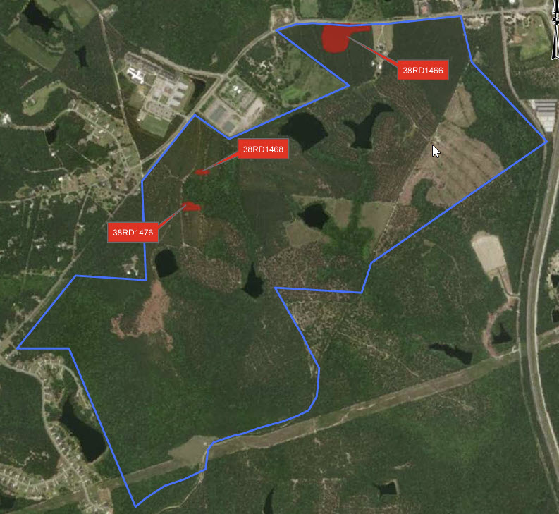
Construction will soon resume on the vast 1,600-acre site in Blythewood, where the Scout Motors manufacturing plant is set to be located.

Last September, Scout had to pause its work following concerns raised by the Environmental Protection Agency (EPA), which had identified evidence of wetlands damage even before the permit was issued.

Additionally, there’s a noteworthy finding indicating that one of the archeological sites, known as 38RD1468, is recommended for inclusion in the National Register of Historic Places (NRHP) under Criterion D. It holds potential for yielding significant insights into the area’s prehistory. However, it’s important to mention that there was not enough data collected during the Phase II investigations to determine its eligibility under other criteria (Criteria A, B, and C).

The Scout Motors project is undeniably intriguing. They are embarking on the production of electric trucks, a technology yet untested in the transportation of goods. This raises questions about the necessity of destroying 75 acres of wetlands for an unproven technology that may or may not compete effectively with traditional trucking methods. While the transition away from fossil fuels is commendable, it’s crucial to ponder whether it should come at the significant cost of our natural environment. Surely, alternative locations with less environmental impact could have been considered for this venture.

Wetland Mitigation Banking

Wetland mitigation banking is an environmental policy tool used to compensate for the loss of wetland functions and values that may occur due to permitted development activities. It represents a market-based approach that allows for the restoration, creation, enhancement, or in some cases, preservation of wetlands to offset impacts from development. Mitigation banks are sites where wetlands and other aquatic resources are restored, created, enhanced, or, in exceptional cases, preserved expressly for the purpose of providing compensatory mitigation in advance of authorized impacts to similar ecosystem types.

History and Regulatory Framework

The concept of wetland mitigation banking emerged in the United States in the 1990s as a response to the loss of wetlands and the requirements of the Clean Water Act (CWA). Section 404 of the CWA establishes a program to regulate the discharge of dredged or fill material into waters of the United States, including wetlands. The U.S. Army Corps of Engineers (USACE) is tasked with permitting such activities, while the Environmental Protection Agency (EPA) provides oversight.

The goal of the CWA is to achieve “no net loss” of wetlands, a policy which has been supported by successive administrations since the late 1980s. Wetland mitigation banking became a practical tool to achieve this goal, providing a way to compensate for wetland losses with the restoration or creation of wetlands elsewhere, ideally leading to equal or greater ecological benefit.

Implementation of Wetland Mitigation Banking

Mitigation banking works on the principle of wetland credits and debits. When wetlands are impacted by development, a debit is incurred, which must then be compensated by purchasing credits from a wetland mitigation bank. These banks are sites where wetlands have been restored or created with the explicit purpose of providing such credits.

The banks themselves are usually operated by private entities, non-profit organizations, or government agencies. They must adhere to strict criteria regarding the ecological restoration and must have a long-term management plan to ensure the persistence of the wetland functions and values over time. Mitigation banks are required to establish financial assurances, such as trusts or letters of credit, to ensure that sufficient funds are available for long-term management.

Benefits of Wetland Mitigation Banking

Mitigation banking offers several advantages over traditional project-by-project mitigation. The scale of mitigation banking often allows for a more comprehensive approach to restoring wetland functions, such as hydrology, water quality, and habitat for wildlife. By consolidating mitigation efforts, banks can potentially restore larger, more ecologically valuable wetlands, rather than piecemeal, often less successful, on-site mitigation efforts.

Moreover, mitigation banking provides a more efficient permitting process for developers. Since the bank sites are pre-approved, developers can purchase credits quickly, allowing for timely project advancement while ensuring that mitigation requirements are met.

Economically, mitigation banking has fostered a new industry, creating jobs and opportunities for environmental restoration and management. It encourages private investment in natural resources and leverages market forces to achieve environmental objectives.

Challenges of Wetland Mitigation Banking

Despite its potential benefits, wetland mitigation banking faces several challenges. The success of a mitigation bank depends on the ecological success of the wetlands restored or created, which can take years or even decades to fully realize. The science of wetland restoration is complex, and outcomes are not guaranteed.

The regulatory framework around wetland mitigation banking can also be complex and variable across different USACE districts, leading to uncertainty for bank developers and customers. There’s also the challenge of ensuring that the mitigation banks provide a level of ecological function equivalent to the wetlands that were lost, known as “functional equivalency.”

Furthermore, there is the issue of “service area,” the geographic limit within which a bank can sell credits. It is essential to ensure that credits are used within an ecologically appropriate distance to maintain landscape-level ecological integrity.

Future Prospects

As recognition of the importance of wetlands to biodiversity, climate regulation, and water quality continues to grow, wetland mitigation banking may become even more prominent in environmental policy and conservation efforts. Innovations in restoration ecology, increased regulatory clarity, and new financing mechanisms could enhance the effectiveness and appeal of wetland mitigation banking.

In the face of climate change, wetlands play a critical role in carbon sequestration and in buffering against extreme weather events, such as storms and floods. Wetland mitigation banks can be strategically located to not only replace lost wetland functions but also to contribute to climate adaptation and resilience.

The use of advanced monitoring technologies, including remote sensing and ecological modeling, can improve the assessment and long-term management of mitigation banks. Additionally, there’s potential for integrating wetland mitigation banking with other market-based conservation tools, like conservation banking for endangered species, which could lead to more comprehensive ecosystem-based management approaches.

Wetland mitigation banking represents an innovative intersection of environmental science, policy, and market economics. It offers a pragmatic solution to the complex problem of wetland loss, aligning economic development with conservation objectives. While it presents challenges, its evolution and refinement could be instrumental in advancing the goal of no net loss of wetlands.

As society moves forward in developing sustainable strategies for land use, mitigation banking will likely continue to play a vital role in reconciling development pressures with the imperative to preserve vital wetland ecosystems. Its success will depend not only on sound science and effective regulation but also on the continued collaboration between developers, conservationists, regulators, and the public. With ongoing attention to these factors, wetland mitigation banking has the potential to serve as a model for balancing human needs with the ecological imperatives of our time.

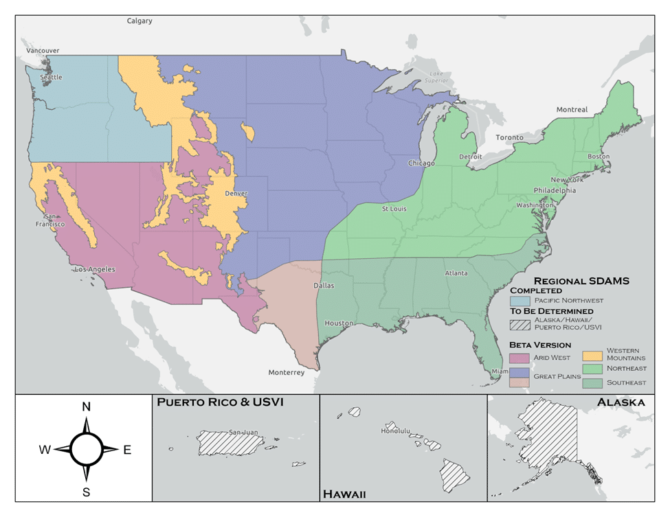
Streamflow Duration Assessment Methods (SDAMs)

The U.S. Army Corps of Engineers (USACE) has developed the Streamflow Duration Assessment Methods (SDAMs), currently in their interim phase, to enhance the management and protection of water resources. This interim phase, reflecting a period of testing and refinement, is crucial for ensuring the accuracy and effectiveness of these methods.

Understanding the Interim Phase of SDAMs

The interim phase of the SDAMs, is a dynamic period where the methods are being field-tested, evaluated, and improved. This phase allows for the incorporation of feedback from various stakeholders, including environmental scientists, water resource managers, and policy makers.

The Role and Importance of SDAMs

Streamflow Duration Assessment Methods are essential for classifying streams based on the duration and frequency of their flow. This classification is vital for:

  1. Environmental Conservation: Assessing the impact of streamflow on aquatic ecosystems.
  2. Water Resource Management: Informing decisions related to water rights, usage, and allocation.
  3. Land Development: Guiding development projects to minimize adverse effects on water resources.
  4. Regulatory Compliance: Aiding in adherence to environmental regulations, such as the Clean Water Act in the U.S.

Implementation Strategies During the Interim Phase

During this interim phase, USACE employs various strategies:

  • Pilot Studies: Conducting field tests in diverse geographical locations to understand the method’s applicability.
  • Stakeholder Feedback: Actively seeking input from users to refine the methods.
  • Data Collection and Analysis: Gathering and analyzing extensive data to validate and improve the methods.
  • Technological Integration: Incorporating advanced technologies such as remote sensing and hydrological modeling.

Challenges and Future Outlook

The interim phase faces challenges like dealing with the impacts of climate change and the need for robust data. Looking ahead, the focus will likely be on:

  • Refining Models: Enhancing the precision and reliability of the methods.
  • Climate Adaptation: Incorporating climate change projections more comprehensively.
  • Expanding Collaboration: Increasing engagement with a broader range of stakeholders.

The U.S. Army Corps of Engineers’ (USACE) Streamflow Duration Assessment Methods (SDAMs) play a significant role in determinations related to the Waters of the United States (WOTUS). WOTUS is a term used in U.S. federal environmental regulations that defines the bodies of water that fall under the jurisdiction of the Clean Water Act (CWA). Understanding this relationship is crucial for environmental protection, water resource management, and compliance with federal laws.

The Role of SDAMs in WOTUS Determinations

  1. Defining Jurisdictional Waters: SDAMs are instrumental in determining whether a particular stream or water body falls under the category of WOTUS. By assessing the duration and frequency of streamflow, these methods help to classify streams as perennial, intermittent, or ephemeral, which is a key factor in WOTUS determinations.
  2. Environmental Regulation Compliance: The classification of water bodies as WOTUS has significant implications for environmental regulation, particularly in terms of permitting, pollution control, and habitat protection under the CWA.
  3. Impact on Land Use and Development: SDAMs influence decisions on land use and development. Projects near water bodies classified as WOTUS might require additional permits and environmental assessments to ensure compliance with the CWA.
  4. Protection of Aquatic Ecosystems: By aiding in the identification of WOTUS, SDAMs contribute to the protection of aquatic ecosystems, especially those dependent on certain streamflow conditions.

Challenges and Complexities in WOTUS Determinations

  1. Changing Definitions and Regulations: The definition of WOTUS has been subject to changes and legal challenges over the years, affecting how SDAMs are applied in regulatory contexts.
  2. Interagency Collaboration: WOTUS determinations often require collaboration between the USACE, the Environmental Protection Agency (EPA), and other federal and state agencies, necessitating a harmonized approach to streamflow assessment.
  3. Site-Specific Assessments: SDAMs need to be adaptable to various geographical and climatic conditions, as streamflow characteristics can vary significantly across different regions.
  4. Incorporating Climate Change Impacts: With changing climate patterns, the assessment of streamflow duration may become more complex, affecting WOTUS determinations over time.

Conclusion

The USACE’s Streamflow Duration Assessment Methods, in their critical interim phase, represent a significant step forward in sustainable water resource management. As these methods evolve, they will play an increasingly important role in protecting and managing water resources effectively for future generations. The ongoing development and refinement during this interim phase, while challenging, are essential for the creation of reliable and universally applicable streamflow assessment tools.

The Streamflow Duration Assessment Methods are deeply intertwined with the determinations of Waters of the United States. They provide a scientific and systematic approach to classifying water bodies, which is fundamental for regulatory compliance, environmental protection, and informed decision-making in land development. As environmental policies and climate conditions continue to evolve, the role of SDAMs in WOTUS determinations remains a key aspect of sustainable water resource management.

August 2023 Definition of Waters of the United States

On August 29, 2023 the US EPA and the US Army Corps of Engineers released a pre-publication version of the conforming amendment to the 2023 definition a Waters of the US. I cannot recall ever having seen a “conforming amendment” in all my years working with this issue. In fact, I am not sure it has ever been done before in any circumstance. I expect the next round of challenges to this rule will focus on this.

The final version of this rule is the weakest version of the Waters of the US we have ever had. The amount of wetlands no longer covered by Clean Water Act protections is the lowest it has ever been including the Navigable Waters Protection Rule era. It is also important to note that the Supreme Court Decision that prompted this new rule was a unanimous (9-0) one. All nine justices were in agreement despite popular media decrying it was the right side of the bench that dominated the Decision.

This is a final rule and becomes effective on the date it is published in the Federal Register. There is no public comment period. I am still unclear as to why the agencies are in such a hurry to not regulate wetlands.

Much of the new rule discusses why it is proper to issue a conforming amendment without a public comment period. The rule itself is fairly brief, in that it provides the edits to the existing Biden rule. The rule itself does not merge the two rules together into a single document. They leave that up to you. However, we have done this for you and the total new conforming rule follows. We will also be hosting a webinar on this new rule on September 28, 2023. Hope to see you there!

Title 33 —Navigation and Navigable Waters

Chapter II —Corps of Engineers, Department of the Army, Department of Defense

Part 328 —Definition of Waters of the United States

Authority: 33 U.S.C. 1251 et seq.

Source: 51 FR 41250, Nov. 13, 1986, unless otherwise noted.

§ 328.3 Definitions.

For the purpose of this regulation these terms are defined as follows:

(a) Waters of the United States means:

(1) Waters which are:

(i)  Currently used, or were used in the past, or may be susceptible to use in interstate or foreign commerce, including all waters which are subject to the ebb and flow of the tide;

(ii) The territorial seas; or

(iii) Interstate waters,

(2)  Impoundments of waters otherwise defined as waters of the United States under this definition, other than impoundments of waters identified under paragraph (a)(5) of this section;

(3) Tributaries of waters identified in paragraph (a)(1) or (2) of this section that are relatively permanent, standing or continuously flowing bodies of water;

(4) Wetlands adjacent to the following waters:

(i) Waters identified in paragraph (a)(1) of this section; or

(ii) Relatively permanent, standing or continuously flowing bodies of water identified in paragraph (a)(2) or (a)(3) of this section and with a continuous surface connection to those waters.

(5) Intrastate lakes and ponds not identified in paragraphs (a)(1) through (4) of this section that are relatively permanent, standing or continuously flowing bodies of water with a continuous surface connection to the waters identified in paragraph (a)(1) or (a)(3) of this section.

(b)  The following are not “waters of the United States” even where they otherwise meet the terms of paragraphs (a)(2) through (5) of this section:

(1)  Waste treatment systems, including treatment ponds or lagoons, designed to meet the requirements of the Clean Water Act;

(2)  Prior converted cropland designated by the Secretary of Agriculture. The exclusion would cease upon a change of use, which means that the area is no longer available for the production of agricultural commodities. Notwithstanding the determination of an area’s status as prior converted cropland by any other Federal agency, for the purposes of the Clean Water Act, the final authority regarding Clean Water Act jurisdiction remains with EPA;

(3)  Ditches (including roadside ditches) excavated wholly in and draining only dry land and that do not carry a relatively permanent flow of water;

(4) Artificially irrigated areas that would revert to dry land if the irrigation ceased;

(5)  Artificial lakes or ponds created by excavating or diking dry land to collect and retain water and which are used exclusively for such purposes as stock watering, irrigation, settling basins, or rice growing;

(6)  Artificial reflecting or swimming pools or other small ornamental bodies of water created by excavating or diking dry land to retain water for primarily aesthetic reasons;

(7)  Waterfilled depressions created in dry land incidental to construction activity and pits excavated in dry land for the purpose of obtaining fill, sand, or gravel unless and until the construction or excavation operation is abandoned and the resulting body of water meets the definition of waters of the United States; and

(8)  Swales and erosional features (e.g., gullies, small washes) characterized by low volume, infrequent, or short duration flow.

(c) In this section, the following definitions apply:

(1)  Wetlands means those areas that are inundated or saturated by surface or ground water at a frequency and duration sufficient to support, and that under normal circumstances do support, a prevalence of vegetation typically adapted for life in saturated soil conditions. Wetlands generally include swamps, marshes, bogs, and similar areas.

(2)  Adjacent means having a continuous surface connection.

(3)  High tide line means the line of intersection of the land with the water’s surface at the maximum height reached by a rising tide. The high tide line may be determined, in the absence of actual data, by a line of oil or scum along shore objects, a more or less continuous deposit of fine shell or debris on the foreshore or berm, other physical markings or characteristics, vegetation lines, tidal gages, or other suitable means that delineate the general height reached by a rising tide. The line encompasses spring high tides and other high tides that occur with periodic frequency but does not include storm surges in which there is a departure from the normal or predicted reach of the tide due to the piling up of water against a coast by strong winds such as those accompanying a hurricane or other intense storm.

(4)  Ordinary high water mark means that line on the shore established by the fluctuations of water and indicated by physical characteristics such as clear, natural line impressed on the bank, shelving, changes in the character of soil, destruction of terrestrial vegetation, the presence of litter and debris, or other appropriate means that consider the characteristics of the surrounding areas.

(5)  Tidal waters means those waters that rise and fall in a predictable and measurable rhythm or cycle due to the gravitational pulls of the moon and sun. Tidal waters end where the rise and fall of the water surface can no longer be practically measured in a predictable rhythm due to masking by hydrologic, wind, or other effects.

EPA Wants Water Professionals to Support New Wetland Rules

The Swamp Stomp

Volume 14, Issue 42

Speaking at the Water Environment Federation Technical Exhibition and Conference at the Ernest N. Morial Convention Center in New Orleans, Gina McCarthy, Environmental Protection Agency (EPA) Administrator, requested that wastewater professionals begin to back the agencies proposed Waters of the U.S. rule. The controversial rule attempts to redefine which bodies of water fall under the Clean Water Act, and, subsequently, the EPA’s jurisdiction.  If the rule is passed then wetlands, streams, and various watersheds would become subject to federal regulations.

McCarthy, however, holds the opinion that in order to maintain safe water supplies in the U.S., then new regulations of wetlands and runoff entering streams and rivers are necessary. Therefore, in an attempt to establish supporting evidence, she requested that water professionals back the rule. She said, “As water managers, as regulators, as technicians, help us explain what this rule is and isn’t.”

McCarthy then cited the August shutdown of the water supply in Toledo, Ohio, as proof for why new regulations ought to be implemented. The shutdown occurred due to a toxic algae bloom—created by added nutrients running into the city’s water supply—infecting Lake Erie. Subsequently, the water was forced to be shut down for two days.

Such an event, McCarthy said, “is what one would call a wake-up call.” She continued, “It’s 2014, folks, 2014, in the most prosperous nation on earth. Yet for two full days, thousands of families couldn’t access life’s most basic necessity.”

Furthermore, McCarthy approached the issue from an economic standpoint. Since the implementation of the Clean Water Act in 1972, the nation’s economy tripled, which, she claims, “goes to show that having environmental protection does not stifle economic growth.” Correlation, however, does not prove causation, so the implication that EPA regulations provide a positive effect of the nation’s economy remains unsubstantiated.

If the Waters of the U.S. rule is passed, then 60 percent of the nation’s streams and wetlands will be subject to the Clean Water Act. McCarthy believes that this will make it easier to maintain healthy water supplies for drinking water. She said, “These streams and wetlands filter pollution, they reduce runoff, they recharge our groundwater supplies. How critical is that in areas of continued or historic droughts?”

“And we know our iconic water bodies like Boston Harbor, like the Chesapeake Bay, like the Great Lakes as a whole, like the Mississippi, like the Missouri, they rely on clean streams and they rely on wetlands to feed into those water supplies, in order to maintain them as viable opportunities for clean drinking water,” she continued.

Climate change, according to McCarthy, also plays a significant role in water quality. She said that the warmer temperatures on Lake Erie this year—possibly resulting from global warming—exacerbated the toxic algae bloom.

Due to the sea levels possibly rising because of global warming, she said, “If we don’t act by 2050, more than $100 billion worth of coastal property could be submerged.” She continued, “But we don’t need to wait until 2050, folks, we know it’s happening today. We’ve already heard about the drought in California that’s historic, that is challenging that great state to find a way to protect their economic growth opportunities, and frankly, to find a way to continue to have their faucets continue to have clean water when they turn them on.”

As the debate over the Waters of the U.S. rule continues, the EPA is reaching for more controversial topics—such as global warming—to justify their claims, depending on economic correlation rather than economic causation to demonstrate economic benefits, and is pleading that wastewater professionals begin to back their proposal.

Congress Pushes Back on New EPA WoUS Rules

Swamp Stomp

Volume 14, Issue 18

On May 1, 2014, 231 lawmakers led by U.S. Representatives Chris Collins (R-NY) and Kurt Schrader (D-Ore.), in the U.S. House of Representatives sent a letter to the EPA and U.S. Army Corp of Engineers to retract its proposed rule to expand federal control under the Clean Water Act. They have citied technical, legal and economic concerns regarding the new rules that have been published in the Federal Register.

Congress is most concerned with the legal position that the EPA and the Corps have taken by more or less basing the entire rule revision on Justice Kennedy’s lone opinion in the Rapanos case. The letter states, “Contrary to your agencies’ claims, this would directly contract prior U.S. Supreme Court decisions, which imposed limits on the extent of federal CWA authority,” the lawmakers stated in the letter. It went on to say that “Based on a legally and scientifically unsound view of the “significant nexus” concept espoused by Justice Kennedy, the rule would places features such as ditches, ephemeral drainages, ponds (natural or manmade), prairie potholes, seeps, flood plains, and other occasionally or seasonally wet areas under federal control.”

The letter also raised concerns with the economic analysis on which the proposed rule is based. In the agency’s analysis, it was determined that the proposed rule would result in a 2.7 percent increase in jurisdictional determinations and would impact an additional 1,332 acres nationwide under Section 404. They applied that 2.7 percent increase across other EPA permitting programs. The agencies determined that the draft proposed rule would result in costs between $133 million and $231 million annually. Based on this, the agencies have said the rule would not have a significant economic impact. The lawmakers disagree, saying errors in the analysis “call into question the veracity of any of the conclusions in the economic analysis.”

House Natural Resources Chairman Doc Hastings (R-Wash.) says the proposal is a massive power grab that must be stopped. “Under this plan, there’d be no body of water in America – including mud puddles and canals – that wouldn’t be at risk from job-destroying federal regulation,” he says.”

Read the full letter here.

To date the EPA has received more than 61,000 comments on the new rules. Your comments and suggestions are needed. So far a total of 789 comments have been published. Many support the new rules and a few do not. If you have any opinion on these new rules, please provide you comments by going to regulations.gov and searching for EPA-HQ-OW-2011-0880. From there you can see the entire docket and submit your comments.

Comments are due by July 21, 2014. If EPA and the Corps finalize these rules it is expected that they will be in force by the fall of this year.